Monthly Archives: August 2019

11pm 8/31 Discussion

Hurricane Dorian Discussion Number 31
NWS National Hurricane Center Miami FL AL052019
1100 PM EDT Sat Aug 31 2019

Data from both Air Force and NOAA Hurricane Hunter aircraft indicate
that Dorian remains a very powerful hurricane, and the satellite
presentation is still quite impressive with a very stable,
well-defined eye. There has been no evidence of concentric eyewalls
in aircraft or microwave data, which is somewhat surprising given
that the intensity has been at category 4 strength for 24 hours.
Both aircraft measured peak flight-level winds that support an
initial intensity of 130 kt. There have been some higher surface
wind estimates from the SFMR, but these data are questionable based
on our experience of very high SFMR-measured wind speeds in recent
strong hurricanes that didn’t match standard flight-level wind
reductions.

Dorian is forecast to continue moving over very warm waters and
into a low-shear environment during the next 12-24 hours, so some
additional strengthening is possible. Difficult-to-predict
eyewall cycles, however, are likely to begin at some point within
the next day or so and could cause fluctuations in intensity. After
72 hours, increasing southerly shear is likely to produce gradual
weakening, but Dorian is foreast to remain a dangerous hurricane
through the forecast period.

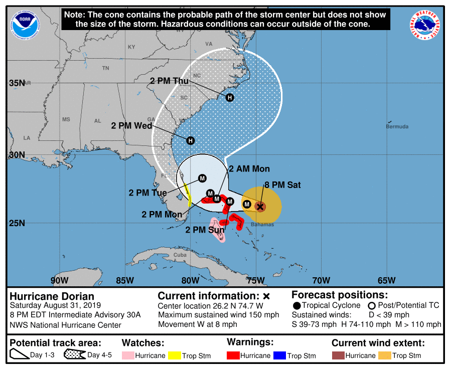
The hurricane is moving westward or 280/7 kt. A high pressure ridge
to the north of Dorian is predicted to remain intact into early
Sunday, and the hurricane should continue westward. By late Sunday,
the dynamical models erode the western portion of the ridge, which
should cause the hurricane to slow down and become nearly stationary
over the northwestern Bahamas in 36 to 48 hours. After that time,
the weakness in the ridge becomes more pronounced, and Dorian is
expected to turn northwestward, and eventually northeastward near
the southeastern United States coast. Although there is general
agreement on this overall scenario, there is still considerable
spread on how close the storm will track to the east coast of
Florida and the southeastern coast of the United States. The latest
HWRF run has shifted westward and takes Dorian across the coast of
central Florida. The 18Z GFS also shifted a little left closer to
the Florida coast. The latest multi-model consensus aids shifted
west closer to the previous NHC track, so very little change to
that forecast was made. Although the exact NHC track forecast lies
east of the Florida peninsula, a track closer to the coast or even
a landfall remain a possibility. Since the updated track was
slightly slower than the previous advisory, no additional watches
are needed for Florida at this time.
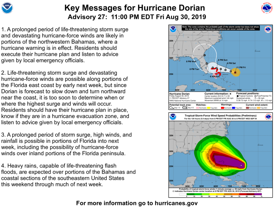
Key Messages:

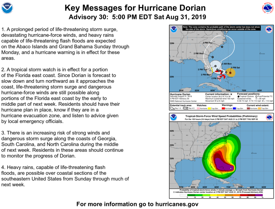
1. A prolonged period of life-threatening storm surge, devastating
hurricane-force winds, and heavy rains capable of life-threatening
flash floods are expected on the Abaco Islands and Grand Bahama
Sunday through Monday, and a hurricane warning is in effect for
these areas.

2. A tropical storm watch is in effect for a portion of the Florida
east coast. Since Dorian is forecast to slow down and turn northward
as it approaches the coast, life-threatening storm surge and
dangerous hurricane-force winds are still possible along portions of
the Florida east coast by the early to middle part of next week.
Residents should have their hurricane plan in place, know if they
are in a hurricane evacuation zone, and listen to advice given by
local emergency officials.

3. There is an increasing risk of strong winds and dangerous storm
surge along the coasts of Georgia, South Carolina, and North
Carolina during the middle of next week. Residents in these areas
should continue to monitor the progress of Dorian.

4. Heavy rains, capable of life-threatening flash floods, are
possible over coastal sections of the southeastern United States
from Monday through Thursday.

8pm Discussion

At 800 PM EDT (0000 UTC), the distinct eye of Hurricane Dorian was located near latitude 26.2 North, longitude 74.7 West. Dorian is moving toward the west near 8 mph (13 km/h), and a slower westward motion should continue for the next day or two, followed by a gradual turn toward the northwest. On this track, the core of Dorian should be near or over portions of the northwestern Bahamas on Sunday, and move closer to the Florida east coast late Monday through Tuesday.

Data from NOAA and Air Force Hurricane Hunter aircraft indicate that the maximum sustained winds remain near 150 mph (240 km/h) with higher gusts. Dorian remains a category 4 hurricane on the Saffir-Simpson Hurricane Wind Scale. Some fluctuations in intensity are likely, but Dorian is expected to remain a powerful hurricane during the next few days.

Hurricane-force winds extend outward up to 30 miles (45 km) from the center and tropical-storm-force winds extend outward up to 105 miles (165 km).

The latest minimum central pressure reported by reconnaissance aircraft is 941 mb (27.79 inches).

2pm Update

DISCUSSION AND OUTLOOK
———————-
At 200 PM EDT (1800 UTC), the distinct eye of Hurricane Dorian was
located near latitude 26.1 North, longitude 73.9 West. Dorian is
moving toward the west near 8 mph (13 km/h), and a slower westward
motion should continue into early next week. On this track, the
core of Dorian should move over the Atlantic well north of the
southeastern and central Bahamas today, be near or over the
northwestern Bahamas on Sunday, and move near the Florida east coast
late Monday through Tuesday.

Data from an Air Force reconnaissance plane indicate that the
maximum sustained winds are near 150 mph (240 km/h) with higher
gusts. Dorian is a category 4 hurricane on the Saffir-Simpson
Hurricane Wind Scale. Some fluctuations in intensity are likely, but
Dorian is expected to remain a powerful hurricane during the next
few days.

Hurricane-force winds extend outward up to 30 miles (45 km) from
the center and tropical-storm-force winds extend outward up to 115
miles (185 km).

The minimum central pressure reported by a reconnaissance plane was
945 mb (27.91 inches).

11pm Advisory – more intensification

BULLETIN
Hurricane Dorian Advisory Number 27
NWS National Hurricane Center Miami FL AL052019
1100 PM EDT Fri Aug 30 2019
…DORIAN EVEN STRONGER…
…NOW PACKING 140 MPH WINDS…
SUMMARY OF 1100 PM EDT…0300 UTC…INFORMATION
———————————————–
LOCATION…25.5N 71.4W
ABOUT 545 MI…880 KM E OF WEST PALM BEACH FLORIDA
ABOUT 375 MI…605 KM E OF THE NORTHWESTERN BAHAMAS
MAXIMUM SUSTAINED WINDS…140 MPH…220 KM/H
PRESENT MOVEMENT…WNW OR 300 DEGREES AT 10 MPH…17 KM/H
MINIMUM CENTRAL PRESSURE…948 MB…28.00 INCHES
DISCUSSION AND OUTLOOK
———————-
At 1100 PM EDT (0300 UTC), the center of Hurricane Dorian was
located near latitude 25.5 North, longitude 71.4 West. Dorian is
moving toward the west-northwest near 10 mph (17 km/h). A slower
west-northwestward to westward motion should begin tonight and
continue into early next week. On this track, the core of Dorian
should move over the Atlantic well north of the southeastern and
central Bahamas tonight and tomorrow, be near or over the
northwestern Bahamas on Sunday, and be near the Florida east
coast late Monday.
Data from a NOAA Hurricane Hunter aircraft indicate that the
maximum sustained winds have increased to near 140 mph (220 km/h)
with higher gusts. Dorian is a category 4 hurricane on the
Saffir-Simpson Hurricane Wind Scale. Some additional strengthening
is possible tonight and Saturday. Although fluctuations in
intensity are possible early next week, Dorian is expected to
remain a powerful hurricane during the next few days.
Hurricane-force winds extend outward up to 30 miles (45 km) from the
center and tropical-storm-force winds extend outward up to 105 miles
(165 km).
The latest minimum central pressure based on data from a NOAA
reconnaissance aircraft is 948 mb (28.00 inches).

Dorian Intensifies


Hurricane Dorian Tropical Cyclone Update
NWS National Hurricane Center Miami FL       AL052019
830 PM EDT Fri Aug 30 2019

...DORIAN STRENGTHENS TO A CATEGORY 4 HURRICANE...

Data from the NOAA Hurricane Hunters indicate that Dorian has
strengthened to an extremely dangerous category 4 hurricane with
maximum sustained winds near 130 mph (215 km/h). This increase in
intensity will be reflected in the forecast issued at 1100 pm EDT
(0300 UTC).

SUMMARY OF 830 PM AST...0030 UTC...INFORMATION
----------------------------------------------
LOCATION...25.3N 71.0W
ABOUT 400 MI...645 KM E OF THE NORTHWESTERN BAHAMAS
ABOUT 575 MI...925 KM E OF WEST PALM BEACH FLORIDA
MAXIMUM SUSTAINED WINDS...130 MPH...215 KM/H
PRESENT MOVEMENT...WNW OR 300 DEGREES AT 10 MPH...17 KM/H
MINIMUM CENTRAL PRESSURE...950 MB...28.05 INCHES