Monthly Archives: August 2019

8pm Update 8/30 – Strong Cat 3.

At 800 PM EDT (0000 UTC), the well-defined eye of Hurricane Dorian was located near latitude 25.3 North, longitude 71.0 West. Dorian is moving toward the west-northwest near 10 mph (17 km/h). A slower west-northwestward to westward motion should begin tonight and continue into early next week. On this track, the core of Dorian should move over the Atlantic well north of the southeastern and central Bahamas tonight and tomorrow, be near or over the northwestern Bahamas on Sunday, and be near the Florida east coast late Monday.

Data from a NOAA Hurricane Hunter aircraft indicate that the maximum sustained winds have increased to near 125 mph (205 km/h) with higher gusts. Dorian is a category 3 hurricane on the Saffir-Simpson Hurricane Wind Scale. Additional strengthening is forecast, and Dorian is anticipated to remain an extremely dangerous hurricane while it moves near the northwestern Bahamas and approaches the Florida peninsula into early next week.

Hurricane-force winds extend outward up to 30 miles (45 km) from the center and tropical-storm-force winds extend outward up to 115 miles (185 km).

The latest minimum central pressure based on data from a NOAA reconnaissance aircraft is 950 mb (28.05 inches).

UF Closed Tuesday

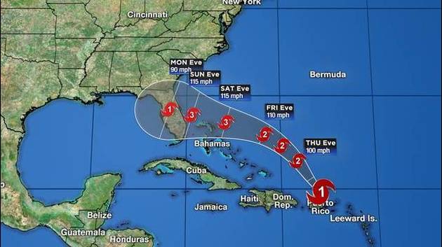
Due to Hurricane Dorian, the University of Florida’s campus in Gainesville will be closed and classes are canceled for Tuesday, Sept. 3. An announcement regarding whether campus will be closed and classes canceled on Wednesday, Sept. 4, will be forthcoming when a decision is made.

Depending on the hurricane’s projected impact, campus shelters may be opened for students, faculty and staff, and their family members. We will provide announcements regarding shelters and other campus-related operations on a regular basis. Please monitor official university channels.

Campus will remain open on a normal holiday schedule for Monday, Sept. 2, including facilities such as the Reitz Student Union, RecSports, libraries, etc.

Only essential university personnel should report for work on Tuesday, Sept.3, and other personnel should not come to campus. For guidance about whether you are essential personnel, please visit https://hr.ufl.edu/forms-policies/policies-managers/essential-personnel/

UF Health clinical and core service personnel should check with their supervisors as to whether they should report to work and provide support to the academic health center for emergency operations.

Faculty, staff and students who are not working at UF Health during the severe weather should not use UF Health parking facilities to safeguard their vehicles. This includes UF garages I, II, III, VI, IX, X, as well as the UF Health Shands garages south of Archer Road.

UF/IFAS and other UF personnel outside of Alachua County should adhere to their county government guidelines and consult their supervisors.

P.K. Yonge Developmental Research School is also closed Tuesday, Sept. 3, and operating on the same schedule as the University of Florida. Should Hurricane Dorian further impact the school schedule next week, communications will be sent to families via phone, email and text. Announcements will be posted on the website (http://pkyonge.ufl.edu) and shared via Facebook.

Supervisors, please ensure that all employees are informed of this closure.

Notices of any scheduling changes can be found through a link on the UF home page or on the information line at 866-UF-FACTS or 866-833-2287. Time reporting information will be provided by UF Human Resources next week.

As always, students and employees in need of immediate assistance should dial 911. Students may also contact U Matter We Care at umatter@ufl.edu or by calling 352- 294-CARE (2273). Employees may call the Employee Assistance Program at 833-306-0103 or go to https://eap.ufl.edu/
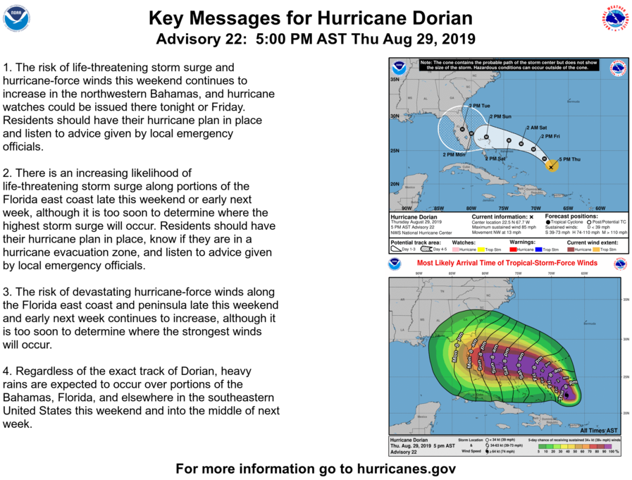
5pm Advisory – 8/29/19

Advisory #22

BULLETIN
Hurricane Dorian Advisory Number  22
NWS National Hurricane Center Miami FL       AL052019
500 PM AST Thu Aug 29 2019

...DORIAN FORECAST TO INTENSIFY DURING THE NEXT COUPLE OF DAYS...


SUMMARY OF 500 PM AST...2100 UTC...INFORMATION
----------------------------------------------
LOCATION...22.5N 67.7W
ABOUT 330 MI...535 KM E OF THE SOUTHEASTERN BAHAMAS
MAXIMUM SUSTAINED WINDS...85 MPH...140 KM/H
PRESENT MOVEMENT...NW OR 325 DEGREES AT 13 MPH...20 KM/H
MINIMUM CENTRAL PRESSURE...986 MB...29.12 INCHES


WATCHES AND WARNINGS
--------------------
There are no coastal watches or warnings in effect.

Interests in the northwestern and central Bahamas should monitor the
progress of Dorian.  Watches may be required for portions of this
area on Friday.


DISCUSSION AND OUTLOOK
----------------------
At 500 PM AST (2100 UTC), the center of Hurricane Dorian was located
near latitude 22.5 North, longitude 67.7 West. Dorian is moving
toward the northwest near 13 mph (20 km/h), and this general
motion is expected to continue through Friday.  A west-northwestward
to westward motion is forecast to begin by Friday night and continue
into the weekend.  On this track, Dorian should move over the
Atlantic well east of the southeastern and central Bahamas tonight
and on Friday, approach the northwestern Bahamas Saturday, and move
near or over portions of the northwest Bahamas on Sunday.

Maximum sustained winds are near 85 mph (140 km/h) with higher
gusts.  Strengthening is forecast during the next few days, and
Dorian is expected to become a major hurricane on Friday, and
remain an extremely dangerous hurricane through the weekend.

Hurricane-force winds extend outward up to 15 miles (30 km) from the
center and tropical-storm-force winds extend outward up to 90 miles
(150 km).

The estimated minimum central pressure is 986 mb (29.12 inches).


HAZARDS AFFECTING LAND
----------------------
RAINFALL:  Dorian is expected to produce the following rainfall
accumulations this weekend into early next week:

The central Bahamas...1 to 2 inches, isolated 4 inches.
The northwestern Bahamas...3 to 5 inches, isolated 7 inches.
Coastal sections of the Southeast United States...5 to 10 inches,
isolated 15 inches.

This rainfall may cause life-threatening flash floods.

SURF:  Swells around the U.S. and British Virgin Islands and
Puerto Rico should gradually diminish today.  Swells are likely to
begin affecting the east-facing shores of the Bahamas and the
southeastern United States coast during the next few days.  These
swells are likely to cause life-threatening surf and rip current
conditions.  Please consult products from your local weather office.

The time to Act is NOW


ORLANDO, Fla. Hurricane Dorian remains on a projected path toward Central Florida, where it could slam the coast with sustained winds of 130 mph as a Category 4 storm.

As of early Thursday, Dorian was a Category 1 hurricane packing 85 mph winds and was located about 150 miles north-northwest of San Juan, Puerto Rico. Dorian is moving northwest at 13 mph.

Strengthening is forecast during the next few days, and Dorian is expected to become a major Category 3 hurricane Saturday then reach Category 4 status on Sunday before it potentially reaches Florida’s east coast Monday morning.

WKMG_hurricanes_Hurricane_Dorian_Advisory_Number_21_1567091034755.jpg

The latest track shows Dorian’s eye approaching Florida early Monday morning.

“It will likely still be a hurricane with Category 2 status as it moves inland to the Orlando metro, if the current path holds true,” News 6 meteorologist Troy Bridges said. “Many of the computer models agree, bringing Dorian into Central Florida.”

On Thursday, Gov. Ron DeSantis assured Floridians that the state is taking every precaution and putting resources in place so officials are ready to respond as soon as possible after the storm. With a weather event this significant, it’s important to note that many residents will lose power.

He urged people across the state to prepare now before it’s too late.

“The time to act is now,” he said.

He stressed the importance of having enough food, water, medications and other essential supplies to last at least seven days.


Hurricane Hunters find Dorian Strengthening

At 1100 p.m. AST (0300 UTC), the center of Hurricane Dorian was located near latitude 19.7 north, longitude 66.0 west. Dorian is moving toward the northwest near 13 mph (20 km/h), and this general motion is expected to continue through Friday. On this track, Dorian should move over the Atlantic well east of the southeastern and central Bahamas on Thursday and Friday.
Maximum sustained winds have increased to near 85 mph (140 km/h) with higher gusts. Dorian is forecast to strengthen into a powerful hurricane during the next couple of days.
Hurricane-force winds extend outward up to 15 miles (30 km) from the center, and tropical-storm-force winds extend outward up to 70 miles (110 km).
The minimum central pressure estimated from hurricane hunter observations is 986 mb (29.12 inches).