BULLETIN
Tropical Depression Twelve Advisory Number   1
NWS National Hurricane Center Miami FL       AL122021
800 PM CVT Tue Aug 31 2021

...NEW TROPICAL DEPRESSION FORMS IN THE EASTERN TROPICAL ATLANTIC...
...FORECAST TO INTENSIFY OVER THE NEXT COUPLE OF DAYS...


SUMMARY OF 800 PM CVT...2100 UTC...INFORMATION
----------------------------------------------
LOCATION...11.2N 21.1W
ABOUT 335 MI...535 KM SE OF THE SOUTHERNMOST CABO VERDE ISLANDS
MAXIMUM SUSTAINED WINDS...35 MPH...55 KM/H
PRESENT MOVEMENT...WNW OR 285 DEGREES AT 16 MPH...26 KM/H
MINIMUM CENTRAL PRESSURE...1006 MB...29.71 INCHES


WATCHES AND WARNINGS
--------------------
There are no coastal watches or warnings in effect.


DISCUSSION AND OUTLOOK
----------------------
At 800 PM CVT (2100 UTC), the center of Tropical Depression Twelve
was located near latitude 11.2 North, longitude 21.1 West. The
depression is moving toward the west-northwest near 16 mph
(26 km/h).  A turn toward the west is expected tonight, and a
westward motion at a faster forward speed is expected during the
next couple of days.

Maximum sustained winds are near 35 mph (55 km/h) with higher gusts.
Strengthening is expected during the next couple of days and the
depression is expected to become a tropical storm tonight or on
Wednesday.

The estimated minimum central pressure is 1006 mb (29.71 inches).


HAZARDS AFFECTING LAND
----------------------
None.
Monthly Archives: August 2021
Ida Advisory # 17A
BULLETIN
Tropical Storm Ida Intermediate Advisory Number 17A
NWS National Hurricane Center Miami FL       AL092021
700 AM CDT Mon Aug 30 2021

...IDA MOVING NORTHWARD OVER SOUTHWESTERN MISSISSIPPI...
...DANGEROUS STORM SURGE AND FLASH FLOODING CONTINUES OVER PORTIONS
OF SOUTHEASTERN LOUISIANA, SOUTHERN MISSISSIPPI, AND SOUTHERN
ALABAMA...


SUMMARY OF 700 AM CDT...1200 UTC...INFORMATION
----------------------------------------------
LOCATION...31.5N 90.8W
ABOUT 65 MI...105 KM SSW OF JACKSON MISSISSIPPI
MAXIMUM SUSTAINED WINDS...45 MPH...75 KM/H
PRESENT MOVEMENT...N OR 360 DEGREES AT 8 MPH...13 KM/H
MINIMUM CENTRAL PRESSURE...993 MB...29.32 INCHES


WATCHES AND WARNINGS
--------------------
CHANGES WITH THIS ADVISORY:

None

SUMMARY OF WATCHES AND WARNINGS IN EFFECT:

A Storm Surge Warning is in effect for...
*Grand Isle, Louisiana, to the Alabama/Florida border

A Tropical Storm Warning is in effect for...
* Grand Isle, Louisiana, to the Alabama/Florida border, including
Lake Pontchartrain, Lake Maurepas, and Metropolitan New Orleans

A Storm Surge Warning means there is a danger of life-threatening
inundation from rising water moving inland from the coastline in
the indicated locations. For a depiction of areas at risk, please
see the National Weather Service Storm Surge Watch/Warning Graphic,
available at hurricanes.gov.  This is a life-threatening situation.
Persons located within these areas should take all necessary
actions to protect life and property from rising water and the
potential for other dangerous conditions. Promptly follow
evacuation and other instructions from local officials.

A Tropical Storm Warning means that tropical storm conditions are
expected somewhere within the warning area.

For storm information specific to your area, including possible
inland watches and warnings, please monitor products issued by your
local National Weather Service forecast office.


DISCUSSION AND OUTLOOK
----------------------
At 700 AM CDT (1200 UTC), the center of Tropical Storm Ida was
located by NOAA Doppler weather radars, satellite data, and surface
observations near latitude 31.5 North, longitude 90.8 West. Ida is
moving toward the north near 8 mph (13 km/h), and this general
motion is forecast to continue today.  A faster northeastward motion
is expected to begin by tonight and continue on Tuesday.  On the
forecast track, the center of Ida will move farther inland over
southwestern Mississippi this morning. Ida is then forecast to move
over central and northeastern Mississippi this afternoon and
tonight, and move across the Tennessee Valley on Tuesday.

Maximum sustained winds have decreased to near 45 mph (75 km/h) with
higher gusts. Additional rapid weakening is forecast during the next
day or so, and Ida is expected to become a tropical depression this
afternoon.

Tropical-storm-force winds extend outward up to 150 miles (240 km),
mainly southeast of the center over water. A coastal marine
observing site at Dauphin Island, Alabama, recently reported
sustained winds of 38 mph (61 km/h) and a gust to 46 mph (74 km/h).
A wind gust to 45 mph (72 km/h) was recently measured at Biloxi,
Mississippi.

The estimated minimum central pressure is 993 mb (29.32 inches).


HAZARDS AFFECTING LAND
----------------------
Key messages for Ida can be found in the Tropical Cyclone
Discussion under AWIPS header MIATCDAT4, WMO header WTNT44 KNHC,
and on the web at hurricanes.gov/graphics_at4.shtml?key_messages.

STORM SURGE:  The combination of a dangerous storm surge and the
tide will cause normally dry areas near the coast to be flooded by
rising waters moving inland from the shoreline.  The water could
reach the following heights above ground somewhere in the indicated
areas if the peak surge occurs at the time of high tide...

Pointe a la Hache, LA to Bay St. Louis, MS including Lake
Borgne...4-6 ft
Lake Maurepas and Lake Pontchartrain...4-6 ft
Bay St. Louis, LA to AL/FL border including Mobile Bay...3-5 ft
Grand Isle, LA to Pointe a la Hache, LA...2-4 ft
Morgan City, LA to Grand Isle, LA...1-3 ft
AL/FL border to Okaloosa/Walton County Line including Pensacola
Bay...1-3 ft

Overtopping of local levees outside of the Hurricane and Storm
Damage Risk Reduction System is possible where local inundation
values may be higher than those shown above.

The deepest water will occur along the immediate coast near and to
the east of the landfall location, where the surge will be
accompanied by large and dangerous waves.  Surge-related flooding
depends on the relative timing of the surge and the tidal cycle, and
can vary greatly over short distances.  For information specific to
your area, please see products issued by your local National Weather
Service forecast office.

WIND: Tropical storm conditions will continue over portions of
Louisiana, southern Mississippi, and southern Alabama through this
morning or early afternoon.

RAINFALL:  Through Tuesday morning, Ida will produce additional
rainfall totals of 4 to 8 with localized higher amounts possible
across portions of southeast Louisiana into far southern
Mississippi. Storm total rainfall accumulations of 10 to 18 inches
with isolated maximum amounts of 24 inches is expected. Heavy rain
combined with storm surge has resulted in catastrophic impacts along
the southeast coast of Louisiana with life threatening flash
flooding and significant riverine flooding continuing farther
inland.

Ida is expected to turn northeast this morning and is forecast to
track across the Middle Tennessee Valley, Ohio Valley and
Mid-Atlantic through Wednesday, producing the following rainfall
totals:

Coastal Alabama to the far western Florida panhandle: An additional
4 to 8 inches resulting in storm total accumulations of 6 to 12
inches with isolated maximum amounts of 15 inches, today through
Tuesday morning.

Central Mississippi into far western Alabama: 4 to 8 inches with
isolated maximum amounts of 12 inches, today through tonight.

Middle Tennessee Valley, Ohio Valley, Central/Southern Appalachians
into the Mid-Atlantic: 3 to 6 inches with isolated higher amounts,
Tuesday into Wednesday.

Considerable flash flooding is possible from the Lower Mississippi
Valley through the Middle Tennessee Valley, Ohio Valley,
Central/Southern Appalachians, and into the Mid-Atlantic. Widespread
minor to isolated major riverine flooding is possible from the Lower
Mississippi Valley into far western Alabama through Wednesday.

TORNADOES:  A few tornadoes are possible today into tonight, mainly
across southeast Mississippi, southwest Alabama, and the western
Florida Panhandle.

SURF:  Swells will continue to affect portions of the northern Gulf
coast through today.  These swells are likely to cause
life-threatening surf and rip current conditions. Please consult
products from your local weather office.
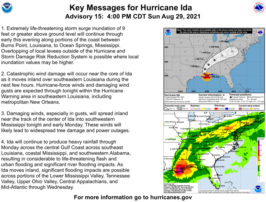
Ida Advisory # 15A
BULLETIN
Hurricane Ida Intermediate Advisory Number 15A
NWS National Hurricane Center Miami FL       AL092021
700 PM CDT Sun Aug 29 2021

...IDA MOVING FURTHER INLAND OVER SOUTHEASTERN LOUISIANA...
...CATASTROPHIC STORM SURGE, EXTREME WINDS, AND FLASH FLOODING
CONTINUE IN PORTIONS OF SOUTHEASTERN LOUISIANA...


SUMMARY OF 700 PM CDT...0000 UTC...INFORMATION
----------------------------------------------
LOCATION...29.9N 90.5W
ABOUT 25 MI...40 KM WSW OF NEW ORLEANS LOUISIANA
ABOUT 55 MI...85 KM SE OF BATON ROUGE LOUISIANA
MAXIMUM SUSTAINED WINDS...120 MPH...195 KM/H
PRESENT MOVEMENT...NW OR 325 DEGREES AT 10 MPH...17 KM/H
MINIMUM CENTRAL PRESSURE...944 MB...27.88 INCHES


WATCHES AND WARNINGS
--------------------
CHANGES WITH THIS ADVISORY:

None.

SUMMARY OF WATCHES AND WARNINGS IN EFFECT:

A Storm Surge Warning is in effect for...
* Morgan City Louisiana to the Alabama/Florida border
* Lake Borgne, Lake Pontchartrain, Lake Maurepas, and Mobile Bay

A Hurricane Warning is in effect for...
* Morgan City Louisiana to the Mouth of the Pearl River
* Lake Pontchartrain, Lake Maurepas, and Metropolitan New Orleans

A Tropical Storm Warning is in effect for...
* Intracoastal City Louisiana to west of Morgan City Louisiana
* Mouth of the Pearl River to the Alabama/Florida border

A Storm Surge Warning means there is a danger of life-threatening
inundation from rising water moving inland from the coastline in
the indicated locations. For a depiction of areas at risk, please
see the National Weather Service Storm Surge Watch/Warning Graphic,
available at hurricanes.gov.  This is a life-threatening situation.
Persons located within these areas should take all necessary
actions to protect life and property from rising water and the
potential for other dangerous conditions. Promptly follow
evacuation and other instructions from local officials.

A Hurricane Warning means that hurricane conditions are expected
somewhere within the warning area.

A Tropical Storm Warning means that tropical storm conditions are
expected somewhere within the warning area.

For storm information specific to your area, including possible
inland watches and warnings, please monitor products issued by your
local National Weather Service forecast office.


DISCUSSION AND OUTLOOK
----------------------
At 700 PM CDT (0000 UTC), the eye of Hurricane Ida was located near
latitude 29.9 North, longitude 90.5 West. Ida is moving toward the
northwest near 10 mph (17 km/h).  A turn toward the north is
expected overnight, followed by a slightly faster northeastward
motion by Monday night and Tuesday.  On the forecast track, the
center of Ida will move farther inland over southeastern Louisiana
tonight.  Ida is then forecast to move well inland over portions of
western Mississippi Monday and Monday night, and move across the
Tennessee Valley on Tuesday.

Doppler radar data indicate that the maximum sustained winds are
near 120 mph (195 km/h) with higher gusts.  Ida is a dangerous
category 3 hurricane on the Saffir-Simpson Hurricane Wind
Scale.  Rapid weakening is expected during the next day or so,
however, Ida is forecast to remain a hurricane through late tonight
and remain a tropical storm until Monday afternoon.

Hurricane-force winds extend outward up to 45 miles (75 km) from the
center and tropical-storm-force winds extend outward up to 150 miles
(240 km). A sustained wind of 62 mph (100 km/h) with a gust of 83
mph (133 km/h) was recently observed at New Orleans International
Airport.  A sustained wind of 62 mph (100 km/h) and a gust of 85 mph
(137 km/h) was recently reported at Frenier Landing, Louisiana.

The estimated minimum central pressure is 944 mb (27.88 inches).
A Florida Coastal Monitoring Program observing station
located northeast of Raceland, Louisiana, recently reported a
minimum pressure of 945 mb (27.91).


HAZARDS AFFECTING LAND
----------------------
Key messages for Ida can be found in the Tropical Cyclone
Discussion under AWIPS header MIATCDAT4, WMO header WTNT44 KNHC,
and on the web at hurricanes.gov/graphics_at4.shtml?key_messages.

STORM SURGE:  The combination of a dangerous storm surge and the
tide will cause normally dry areas near the coast to be flooded by
rising waters moving inland from the shoreline.  The water could
reach the following heights above ground somewhere in the indicated
areas if the peak surge occurs at the time of high tide...

Morgan City, LA to Bay St. Louis, MS including Lake
Borgne...7-11 ft
Lake Pontchartrain...5-8 ft
Bay St. Louis, MS to Ocean Springs, MS...4-7 ft
Lake Maurepas...4-6 ft
Ocean Springs to AL/FL border including Mobile Bay...3-5 ft
Intracoastal City, LA to Morgan City, LA including Vermilion
Bay...1-3 ft
AL/FL border to Okaloosa/Walton County Line including Pensacola
Bay...1-3 ft

Overtopping of local levees outside of the Hurricane and Storm
Damage Risk Reduction System is possible where local inundation
values may be higher than those shown above.

The deepest water will occur along the immediate coast near and to
the east of the landfall location, where the surge will be
accompanied by large and dangerous waves.  Surge-related flooding
depends on the relative timing of the surge and the tidal cycle, and
can vary greatly over short distances.  For information specific to
your area, please see products issued by your local National Weather
Service forecast office.

WIND:  Catastrophic wind damage is likely near the core of Ida as
it moves farther inland over southeastern Louisiana through this
evening.

Hurricane conditions will spread farther inland within the Hurricane
Warning area over southeastern Louisiana tonight. Tropical storm
conditions will also spread inland over portions of Louisiana
and Mississippi tonight and Monday.

RAINFALL:  Heavy rainfall from Ida will continue to impact the
southeast Louisiana coast, spreading northeast into the Lower
Mississippi Valley this evening into Monday.  Total rainfall
accumulations of 10 to 18 inches with isolated maximum amounts of 24
inches are possible across southeast Louisiana into far southern
Mississippi through Monday. This is likely to result in life-
threatening flash and urban flooding and significant river
flooding impacts.

Ida is forecast to turn to the northeast on Monday and track across
the Middle Tennessee Valley and Upper Ohio Valley through Wednesday,
producing the following rainfall totals:

Coastal Alabama to the far western Florida panhandle: 5 to 10 inches
with isolated maximum amounts of 15 inches, today through Tuesday
morning.

Central Mississippi: 4 to 8 inches with isolated maximum amounts of
12 inches, tonight through Monday night.

Middle Tennessee Valley, Upper Ohio Valley, Central Appalachians
into the Mid-Atlantic: 3 to 6 inches with isolated higher amounts,
Tuesday into Wednesday.

These rainfall totals will result in considerable flash flooding
along with widespread minor to isolated major riverine flooding from
the Lower Mississippi Valley into far western Alabama.

TORNADOES:  Tornadoes will be most likely through Monday over
southeast Louisiana, southern Mississippi, southwest Alabama, and
the western Florida Panhandle.  A few tornadoes are also possible
farther north across much of Mississippi and Alabama on Monday.

SURF:  Swells will continue to affect the northern Gulf coast
through early Monday.  These swells are likely to cause
life-threatening surf and rip current conditions. Please consult
products from your local weather office.
🐊 Preseason show schedule 🐊
GAINESVILLE, Fla. – The 2021 Gators Football Preseason Special, presented by your local Toyota dealers, debuts Monday, Aug. 30 at 7 p.m. ET on Bally Sports Florida and will air several times leading up to the Gators’ season opener against FAU on Sept. 4.
Hosted by the Voice of the Gators, Mick Hubert, the preseason special takes look at the upcoming season and features exclusive interviews with Head Coach Dan Mullen, Defensive Coordinator Todd Grantham and new assistant coaches Garrick McGee, Wesley McGriff and Jules Montinar.
A full viewing schedule can be found below. Airing schedule is subject to change.
- Bally Sports Florida Airing Schedule
- Monday, Aug 30 at 7 p.m.
- Tuesday, Aug 31 at 10:30 p.m.
- Wednesday, Sep 1 at 9:30 a.m.
- Wednesday, Sep 1 at 4 p.m.
- Thursday, Sep 2 at 5 p.m.
- Friday, Sep 3 at 5:30 p.m.
- Friday, Sep 3 at 11 p.m.
- Saturday, Sep 4 at 10:30 a.m.
- Bally Sports Sun Airing Schedule
- Monday, Aug. 30 at 11 p.m.
- Tuesday, Aug. 31 at 7:30 a.m.
- Tuesday, Aug. at 5:30 p.m.
- Wednesday, Sep. 1 at 5:30 p.m.
- Thursday, Sep 2 at 3 p.m.
Gators Football 2021 Ticket Information:
Tickets for the 2021 season are now available, and fans have different options to purchase them:
- Visit FloridaGators.com/tickets
- Call the Gators Ticket Office at (352) 375-4683 Monday-Friday, 8:30 a.m. to 5:00 p.m.
- Complete the ticket information form here to be contacted by a Gators Ticket Office representative.
Follow the Gators Ticket Office on twitter at @GatorsTix for all the latest information on Gator tickets.
Ida Advisory # 15
BULLETIN
Hurricane Ida Advisory Number  15
NWS National Hurricane Center Miami FL       AL092021
400 PM CDT Sun Aug 29 2021

...IDA MOVING NORTHWESTWARD OVER SOUTHEASTERN LOUISIANA...
...CATASTROPHIC STORM SURGE, EXTREME WINDS, AND FLASH FLOODING
CONTINUES IN PORTIONS OF SOUTHEASTERN LOUISIANA...


SUMMARY OF 400 PM CDT...2100 UTC...INFORMATION
----------------------------------------------
LOCATION...29.5N 90.6W
ABOUT 45 MI...75 KM SW OF NEW ORLEANS LOUISIANA
ABOUT 70 MI...115 KM SSE OF BATON ROUGE LOUISIANA
MAXIMUM SUSTAINED WINDS...130 MPH...215 KM/H
PRESENT MOVEMENT...NW OR 325 DEGREES AT 10 MPH...17 KM/H
MINIMUM CENTRAL PRESSURE...938 MB...27.70 INCHES


WATCHES AND WARNINGS
--------------------
CHANGES WITH THIS ADVISORY:

The Hurricane Warning along the coast of Louisiana from Morgan
City to Intracoastal City has been changed to a Tropical Storm
Warning.

The Tropical Storm Warning from Cameron to Intracoastal City
Louisiana has been discontinued.

The Storm Surge Warning west of Morgan City has been discontinued.

SUMMARY OF WATCHES AND WARNINGS IN EFFECT:

A Storm Surge Warning is in effect for...
* Morgan City Louisiana to the Alabama/Florida border
* Lake Borgne, Lake Pontchartrain, Lake Maurepas, and Mobile Bay

A Hurricane Warning is in effect for...
* Morgan City Louisiana to the Mouth of the Pearl River
* Lake Pontchartrain, Lake Maurepas, and Metropolitan New Orleans

A Tropical Storm Warning is in effect for...
* Intracoastal City Louisiana to west of Morgan City Louisiana
* Mouth of the Pearl River to the Alabama/Florida border

A Storm Surge Warning means there is a danger of life-threatening
inundation from rising water moving inland from the coastline in
the indicated locations. For a depiction of areas at risk, please
see the National Weather Service Storm Surge Watch/Warning Graphic,
available at hurricanes.gov.  This is a life-threatening situation.
Persons located within these areas should take all necessary
actions to protect life and property from rising water and the
potential for other dangerous conditions. Promptly follow
evacuation and other instructions from local officials.

A Hurricane Warning means that hurricane conditions are expected
somewhere within the warning area.

A Tropical Storm Warning means that tropical storm conditions are
expected somewhere within the warning area.

For storm information specific to your area, including possible
inland watches and warnings, please monitor products issued by your
local National Weather Service forecast office.


DISCUSSION AND OUTLOOK
----------------------
At 400 PM CDT (2100 UTC), the eye of Hurricane Ida was located
near latitude 29.5 North, longitude 90.6 West. Ida is moving toward
the northwest near 10 mph (17 km/h).  A turn toward the north
is expected overnight, followed by a slightly faster northeastward
motion by Monday night and Tuesday.  On the forecast track, the
center of Ida will move farther inland over southeastern Louisiana
tonight.  Ida is then forecast to move well inland over portions of
western Mississippi Monday and Monday night, and move across the
Tennessee Valley on Tuesday.

Doppler radar data indicate that the maximum sustained winds are
near 130 mph (215 km/h) with higher gusts.  Ida is an extremely
dangerous category 4 hurricane on the Saffir-Simpson Hurricane Wind
Scale.  Rapid weakening is expected during the next day or so,
however Ida is forecast to remain a hurricane through late tonight
and remain a tropical storm until Monday afternoon.

Hurricane-force winds extend outward up to 45 miles (75 km) from the
center and tropical-storm-force winds extend outward up to 150 miles
(240 km). A Weatherflow station near Dulac just reported sustained
winds of 93 mph (150 km/h) and a gust to 135 mph (217 km/h).  A
Florida Coastal Monitoring Program observing station at the South
Lafourche airport recently reported a sustained wind of 91 mph (146
km/h) and wind gust of 122 mph (196 km/h). A sustained wind of 51
mph (81 km/h) and a gust to 82 mph (131 km/h) was recently reported
at Lakefront Airport in New Orleans.

The estimated minimum central pressure is 938 mb (27.70 inches).


HAZARDS AFFECTING LAND
----------------------
Key messages for Ida can be found in the Tropical Cyclone
Discussion under AWIPS header MIATCDAT4, WMO header WTNT44 KNHC,
and on the web at hurricanes.gov/graphics_at4.shtml?key_messages.

STORM SURGE:  The combination of a dangerous storm surge and the
tide will cause normally dry areas near the coast to be flooded by
rising waters moving inland from the shoreline.  The water could
reach the following heights above ground somewhere in the indicated
areas if the peak surge occurs at the time of high tide...

Port Fourchon, LA to Mouth of the Mississippi River...12-16 ft
Morgan City, LA to Port Fourchon, LA...8-12 ft
Mouth of the Mississippi River to Bay St. Louis, MS including Lake
Borgne...8-12 ft
Bay St. Louis, MS to Ocean Springs, MS...5-8 ft
Lake Pontchartrain...5-8 ft
Ocean Springs, MS to MS/AL border...4-7 ft
Lake Maurepas...4-6 ft
MS/AL border to AL/FL border including Mobile Bay...3-5 ft
Intracoastal City, LA to Morgan City, LA including Vermilion
Bay...1-3 ft
AL/FL border to Okaloosa/Walton County Line including Pensacola
Bay...1-3 ft

Overtopping of local levees outside of the Hurricane and Storm
Damage Risk Reduction System is possible where local inundation
values may be higher than those shown above.

The deepest water will occur along the immediate coast near and to
the east of the landfall location, where the surge will be
accompanied by large and dangerous waves.  Surge-related flooding
depends on the relative timing of the surge and the tidal cycle, and
can vary greatly over short distances.  For information specific to
your area, please see products issued by your local National Weather
Service forecast office.

WIND:  Catastrophic wind damage is likely near the core of Ida as
it moves inland over southeastern Louisiana through this evening.

Hurricane conditions will spread farther inland within the Hurricane
Warning area over southeastern Louisiana tonight. Tropical storm
conditions will also spread inland over portions of Louisiana
and Mississippi tonight and Monday.

RAINFALL:  Heavy rainfall from Ida will continue to impact the
southeast Louisiana coast, spreading northeast into the Lower
Mississippi Valley this evening into Monday.  Total rainfall
accumulations of 10 to 18 inches with isolated maximum amounts of 24
inches are possible across southeast Louisiana into far southern
Mississippi through Monday. This is likely to result in life-
threatening flash and urban flooding and significant river
flooding impacts.

Ida is forecast to turn to the northeast on Monday and track across
the Middle Tennessee Valley and Upper Ohio Valley through Wednesday,
producing the following rainfall totals:

Coastal Alabama to the far western Florida panhandle: 5 to 10 inches
with isolated maximum amounts of 15 inches, today through Tuesday
morning.

Central Mississippi: 4 to 8 inches with isolated maximum amounts of
12 inches, tonight through Monday night.

Middle Tennessee Valley, Upper Ohio Valley, Central Appalachians
into the Mid-Atlantic: 3 to 6 inches with isolated higher amounts,
Tuesday into Wednesday.

These rainfall totals will result in considerable flash flooding
along with widespread minor to isolated major riverine flooding from
the Lower Mississippi Valley into far western Alabama.

TORNADOES:  Tornadoes will be most likely through Monday over
southeast Louisiana, southern Mississippi, southwest Alabama, and
the western Florida Panhandle.  A few tornadoes are also possible
farther north across much of Mississippi and Alabama on Monday.

SURF:  Swells will continue to affect the northern Gulf coast
through early Monday.  These swells are likely to cause
life-threatening surf and rip current conditions. Please consult
products from your local weather office.
Ida Advisory # 14 A
BULLETIN
Hurricane Ida Intermediate Advisory Number 14A
NWS National Hurricane Center Miami FL       AL092021
100 PM CDT Sun Aug 29 2021

...EYE OF EXTREMELY DANGEROUS CATEGORY 4 HURRICANE IDA MOVING OVER
SOUTHEASTERN LOUISIANA...
...CATASTROPHIC STORM SURGE, EXTREME WINDS, AND FLASH FLOODING IN
PORTIONS OF LOUISIANA...


SUMMARY OF 100 PM CDT...1800 UTC...INFORMATION
----------------------------------------------
LOCATION...29.2N 90.3W
ABOUT 20 MI...30 KM W OF GRAND ISLE LOUISIANA
ABOUT 55 MI...90 KM SSW OF NEW ORLEANS LOUISIANA
MAXIMUM SUSTAINED WINDS...150 MPH...240 KM/H
PRESENT MOVEMENT...NW OR 320 DEGREES AT 13 MPH...20 KM/H
MINIMUM CENTRAL PRESSURE...930 MB...27.46 INCHES


WATCHES AND WARNINGS
--------------------
CHANGES WITH THIS ADVISORY:

None

SUMMARY OF WATCHES AND WARNINGS IN EFFECT:

A Storm Surge Warning is in effect for...
* Intracoastal City Louisiana to the Alabama/Florida border
* Vermilion Bay, Lake Borgne, Lake Pontchartrain, Lake Maurepas,
and Mobile Bay

A Hurricane Warning is in effect for...
* Intracoastal City Louisiana to the Mouth of the Pearl River
* Lake Pontchartrain, Lake Maurepas, and Metropolitan New Orleans

A Tropical Storm Warning is in effect for...
* Cameron Louisiana to west of Intracoastal City Louisiana
* Mouth of the Pearl River to the Alabama/Florida border

A Storm Surge Warning means there is a danger of life-threatening
inundation from rising water moving inland from the coastline in
the indicated locations. For a depiction of areas at risk, please
see the National Weather Service Storm Surge Watch/Warning Graphic,
available at hurricanes.gov.  This is a life-threatening situation.
Persons located within these areas should take all necessary
actions to protect life and property from rising water and the
potential for other dangerous conditions. Promptly follow
evacuation and other instructions from local officials.

A Hurricane Warning means that hurricane conditions are expected
somewhere within the warning area.

A Tropical Storm Warning means that tropical storm conditions are
expected somewhere within the warning area.

For storm information specific to your area, including possible
inland watches and warnings, please monitor products issued by your
local National Weather Service forecast office.


DISCUSSION AND OUTLOOK
----------------------
At 100 PM CDT (1800 UTC), the eye of Hurricane Ida was located by
NWS Doppler radar near latitude 29.2 North, longitude 90.3 West.
Ida is moving toward the northwest near 13 mph (20 km/h), and a
slightly slower northwestward motion should continue through this
evening.  A turn toward the north should occur by Monday morning,
followed by a slightly faster northeastward motion by Monday night
and Tuesday.  On the forecast track, the center of Ida will move
farther inland over southeastern Louisiana this afternoon and
tonight.  Ida is then forecast to move well inland over portions of
Louisiana and western Mississippi Monday and Monday night, and move
across the Tennessee Valley on Tuesday.

Maximum sustained winds are near 150 mph (240 km/h) with higher
gusts.  Ida is an extremely dangerous category 4 hurricane on the
Saffir-Simpson Hurricane Wind Scale.  Rapid weakening is expected
during the next day or so, however Ida is forecast to remain a
hurricane through late tonight.

Hurricane-force winds extend outward up to 50 miles (85 km) from
the center and tropical-storm-force winds extend outward up to 150
miles (240 km).  A Florida Coastal Monitoring Observation Tower at
South Lafourche Airport recently reported a sustained wind of
70 mph (113 km/h) and a wind gust of 102 mph (164 km/h).  A
sustained wind of 47 mph (60 km/h) and a gust of 63 mph (102 km/h)
were recently reported at Lakefront Airport in New Orleans.

A NOAA National Ocean Service tide gauge in Shell Beach, Louisiana,
recently reported a water level of 6.8 feet above mean higher high
water, which is an approximation of inundation in that area.

The estimated minimum central pressure is 930 mb (27.46 inches).


HAZARDS AFFECTING LAND
----------------------
Key messages for Ida can be found in the Tropical Cyclone
Discussion under AWIPS header MIATCDAT4, WMO header WTNT44 KNHC,
and on the web at hurricanes.gov/graphics_at4.shtml?key_messages.

STORM SURGE:  The combination of a dangerous storm surge and the
tide will cause normally dry areas near the coast to be flooded by
rising waters moving inland from the shoreline.  The water could
reach the following heights above ground somewhere in the indicated
areas if the peak surge occurs at the time of high tide...

Port Fourchon, LA to Mouth of the Mississippi River...12-16 ft
Morgan City, LA to Port Fourchon, LA...8-12 ft
Mouth of the Mississippi River to Bay St. Louis, MS including Lake
Borgne...8-12 ft
Bay St. Louis, MS to Ocean Springs, MS...5-8 ft
Burns Point, LA to Morgan City, LA...5-8 ft
Lake Pontchartrain...5-8 ft
Ocean Springs, MS to MS/AL border...4-7 ft
Lake Maurepas...4-6 ft
East of Intracoastal City, LA to Burns Point, LA including Vermilion
Bay...3-5 ft
MS/AL border to AL/FL border including Mobile Bay...3-5 ft
Rockefeller Wildlife Refuge, LA to Intracoastal City, LA...1-3 ft
AL/FL border to Okaloosa/Walton County Line including Pensacola
Bay...1-3 ft

Overtopping of local levees outside of the Hurricane and Storm
Damage Risk Reduction System is possible where local inundation
values may be higher than those shown above.

The deepest water will occur along the immediate coast near and to
the east of the landfall location, where the surge will be
accompanied by large and dangerous waves.  Surge-related flooding
depends on the relative timing of the surge and the tidal cycle, and
can vary greatly over short distances.  For information specific to
your area, please see products issued by your local National Weather
Service forecast office.

WIND:  Catastrophic wind damage is likely near the core of Ida
as it moves inland over southeastern Louisiana through this
afternoon.

Hurricane conditions will spread farther inland within the Hurricane
Warning area over southeastern Louisiana through tonight. Tropical
storm conditions will also spread inland over portions of Louisiana
and Mississippi tonight and Monday.

RAINFALL:  Heavy rainfall from Ida will continue to impact the
southeast Louisiana coast this morning, spreading northeast into the
Lower Mississippi Valley later today into Monday.  Total rainfall
accumulations of 10 to 18 inches with isolated maximum amounts of
24 inches are possible across southeast Louisiana into far southern
Mississippi through Monday. This is likely to result in
life-threatening flash and urban flooding and significant riverine
flooding impacts.

Ida is forecast to turn to the northeast early Monday and track
across the Middle Tennessee Valley and Upper Ohio Valley through
Wednesday, producing the following rainfall totals:

Coastal Alabama to the far western Florida panhandle: 5 to 10 inches
with isolated maximum amounts of 15 inches, today through Tuesday
morning.

Central Mississippi: 4 to 8 inches with isolated maximum amounts of
12 inches, tonight through Monday night.

Middle Tennessee Valley, Upper Ohio Valley, Central Appalachians
into the Mid-Atlantic: 3 to 6 inches with isolated higher amounts,
Tuesday into Wednesday.

These rainfall totals will result in considerable flash and riverine
flooding.

TORNADOES:  Tornadoes will be most likely through Monday over
southeast Louisiana, southern Mississippi, southwest Alabama, and
the western Florida Panhandle. A few tornadoes are also possible
farther north across much of Mississippi and Alabama on Monday.

SURF:  Swells will affect the northern Gulf coast through early
Monday.  These swells are likely to cause life-threatening surf and
rip current conditions. Please consult products from your local
weather office.
Congrats Coach Mary Wise. Win # 900
SACRAMENTO, Calif. – The sixth-ranked Florida volleyball team grabbed its second sweep in as many matches after topping UC Davis in straight-sets on Saturday afternoon.
Florida won a tight battle in the first set, taking the frame 25-21, then followed with a statement 25-11 victory in the second. The Gators closed out the match with a 25-18 win in the final set.
With the win, Mary Wise claimed her 900th victory at the University of Florida. She is just the second female coach in Division I history to reach 900 wins at a single school and she currently sits at 981 wins in her career overall.
Thayer Hall led the offensive attack for the Gators, posting 11 kills on the morning. Merritt Beason followed with nine kills of her own, while T’ara Ceasar and Marlie Monserez posted seven apiece in the match.
Middle blockers Lauren Forte and Lauren Dooley each added five kills of their own in the three-setter.
Marlie Monserez led the Gators to a .352 clip in the match, dishing out 29 assists.
Florida was dominate at the net, posting 10.0 blocks. Forte registered a team-high eight blocks in the match, a Florida career-best for the redshirt senior. Ceasar added three blocks, while Beason posted two from the right side.
Elli McKissock recorded nine digs to lead the backcourt defense, followed by eight apiece from Monserez and Hall.
The Gators close out the Hornet Invitational against Sacramento State at 10 p.m. ET. The match is slated to air on ESPN+.
Update Statement
Hurricane Ida Tropical Cyclone Update
NWS National Hurricane Center Miami FL       AL092021
800 AM CDT Sun Aug 29 2021

...800 AM CDT POSITION UPDATE...
...HURRICANE-FORCE WINDS OCCURING IN PORTIONS OF SOUTHEASTERN
LOUISIANA...

An elevated NOAA C-MAN station at Southwest Pass, Louisiana,
recently reported a sustained wind of 105 mph (169 km/h) and a wind
gust of 121 mph (194 km/h).

The latest minimum central pressure based on data from an Air Force
Reserve Hurricane Hunter aircraft is 930 mb (27.46 in).


SUMMARY OF 800 AM CDT...1300 UTC...INFORMATION
----------------------------------------------
LOCATION...28.6N 89.7W
ABOUT 50 MI...80 KM SSE OF GRAND ISLE LOUISIANA
ABOUT 100 MI...160 KM SSE OF NEW ORLEANS LOUISIANA
MAXIMUM SUSTAINED WINDS...150 MPH...240 KM/H
PRESENT MOVEMENT...NW OR 320 DEGREES AT 15 MPH...24 KM/H
MINIMUM CENTRAL PRESSURE...930 MB...27.46 INCHES
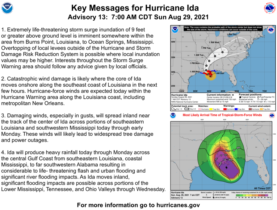
Cat. 4 Ida Advisory 13
BULLETIN
Hurricane Ida Special Advisory Number  13
NWS National Hurricane Center Miami FL       AL092021
700 AM CDT Sun Aug 29 2021

...LIFE-THREATENING STORM SURGE AND HURRICANE-FORCE WINDS REACHING
THE COAST OF SOUTHEASTERN LOUISIANA...
...EXTREMELY DANGEROUS CATEGORY 4 HURRICANE IDA EXPECTED TO MAKE
LANDFALL IN SOUTHEASTERN LOUISIANA IN THE NEXT FEW HOURS...


SUMMARY OF 700 AM CDT...1200 UTC...INFORMATION
----------------------------------------------
LOCATION...28.5N 89.6W
ABOUT 50 MI...85 KM SW OF THE MOUTH OF THE MISSISSIPPI RIVER
ABOUT 100 MI...160 KM SE OF HOUMA LOUISIANA
MAXIMUM SUSTAINED WINDS...150 MPH...240 KM/H
PRESENT MOVEMENT...NW OR 320 DEGREES AT 15 MPH...24 KM/H
MINIMUM CENTRAL PRESSURE...933 MB...27.55 INCHES


WATCHES AND WARNINGS
--------------------
CHANGES WITH THIS ADVISORY:

None.

SUMMARY OF WATCHES AND WARNINGS IN EFFECT:

A Storm Surge Warning is in effect for...
* East of Rockefeller Wildlife Refuge Louisiana to the
Alabama/Florida border
* Vermilion Bay, Lake Borgne, Lake Pontchartrain, Lake Maurepas,
and Mobile Bay

A Hurricane Warning is in effect for...
* Intracoastal City Louisiana to the Mouth of the Pearl River
* Lake Pontchartrain, Lake Maurepas, and Metropolitan New Orleans

A Tropical Storm Warning is in effect for...
* Cameron Louisiana to west of Intracoastal City Louisiana
* Mouth of the Pearl River to the Alabama/Florida border

A Storm Surge Warning means there is a danger of life-threatening
inundation from rising water moving inland from the coastline in
the indicated locations. For a depiction of areas at risk, please
see the National Weather Service Storm Surge Watch/Warning Graphic,
available at hurricanes.gov.  This is a life-threatening situation.
 Persons located within these areas should take all necessary
actions to protect life and property from rising water and the
potential for other dangerous conditions. Promptly follow
evacuation and other instructions from local officials.

A Hurricane Warning means that hurricane conditions are expected
somewhere within the warning area.

A Tropical Storm Warning means that tropical storm conditions are
expected somewhere within the warning area.

For storm information specific to your area, including possible
inland watches and warnings, please monitor products issued by your
local National Weather Service forecast office.


DISCUSSION AND OUTLOOK
----------------------
At 700 AM CDT (1200 UTC), the eye of Hurricane Ida was located
near latitude 28.5 North, longitude 89.6 West. Ida is moving toward
the northwest near 15 mph (24 km/h), and this general motion should
continue through tonight and early Monday, followed by a slower
northward motion on Monday afternoon.  A northeastward turn is
forecast by Monday night.  On the forecast track, the center of Ida
will make landfall along the coast of southeastern Louisiana
within the hurricane warning area late this morning or early this
afternoon.  Ida is then forecast to move well inland over portions
of Louisiana and western Mississippi on Monday and Monday night.

Reports from Air Force Reserve and NOAA hurricane hunter aircraft
indicate that the maximum sustained winds are near 150 mph (240
km/h) with higher gusts.  Ida is an extremely dangerous category 4
hurricane on the Saffir-Simpson Hurricane Wind Scale.  Some
additional strengthening is forecast, and Ida is expected to be an
extremely dangerous major hurricane when it makes landfall along the
Louisiana coast.  Rapid weakening is expected after landfall.

Hurricane-force winds extend outward up to 50 miles (85 km) from the
center and tropical-storm-force winds extend outward up to 140 miles
(220 km).  An elevated NOAA C-MAN station at Pilot's Station East
near Southwest Pass, Louisiana, recently reported a sustained wind
of 92 mph (148 km/h) and a gust to 113 mph (181 km/h).  Another
NOAA elevated C-MAN station at Southwest Pass recently reported a
sustained wind of 92 mph (148 km/h).

The latest minimum central pressure reported by a NOAA
reconnaissance aircraft is 933 mb (27.55 inches).


HAZARDS AFFECTING LAND
----------------------
Key messages for Ida can be found in the Tropical Cyclone
Discussion under AWIPS header MIATCDAT4, WMO header WTNT44 KNHC,
and on the web at hurricanes.gov/graphics_at4.shtml?key_messages.

STORM SURGE:  The combination of a dangerous storm surge and the
tide will cause normally dry areas near the coast to be flooded by
rising waters moving inland from the shoreline.  The water could
reach the following heights above ground somewhere in the indicated
areas if the peak surge occurs at the time of high tide...

Port Fourchon, LA to Mouth of the Mississippi River...12-16 ft
Morgan City, LA to Port Fourchon, LA...8-12 ft
Mouth of the Mississippi River to Bay St. Louis, MS including Lake
Borgne...8-12 ft
Burns Point, LA to Morgan City, LA...6-9 ft
Bay St. Louis, MS to Ocean Springs, MS...6-9 ft
Lake Pontchartrain...5-8 ft
Ocean Springs, MS to MS/AL border...4-7 ft
Intracoastal City, LA to Burns Point, LA including Vermilion
Bay...4-6 ft
Lake Maurepas...4-6 ft
Pecan Island, LA to Intracoastal City, LA...2-4 ft
MS/AL border to AL/FL border including Mobile Bay...3-5 ft
Sabine Pass to Pecan Island, LA...1-3 ft
AL/FL border to Okaloosa/Walton County Line including Pensacola
Bay...1-3 ft

Overtopping of local levees outside of the Hurricane and Storm
Damage Risk Reduction System is possible where local inundation
values may be higher than those shown above.

The deepest water will occur along the immediate coast near and to
the east of the landfall location, where the surge will be
accompanied by large and dangerous waves.  Surge-related flooding
depends on the relative timing of the surge and the tidal cycle, and
can vary greatly over short distances.  For information specific to
your area, please see products issued by your local National Weather
Service forecast office.

WIND:  Catastrophic wind damage is likely where the core of Ida
moves onshore along the southeast coast of Louisiana in the next
few hours.

Hurricane conditions are expected in the Hurricane Warning
area along the Louisiana coast beginning by later this morning with
tropical storm conditions expected to begin by early this morning.
These conditions will spread inland over portions of Louisiana and
Mississippi tonight and Monday.

RAINFALL:  Heavy rainfall from Ida will begin to impact the
southeast Louisiana coast this morning, spreading northeast into the
Lower Mississippi Valley later today into Monday.  Total rainfall
accumulations of 10 to 18 inches with isolated maximum amounts of
24 inches are possible across southeast Louisiana into far southern
Mississippi through Monday. This is likely to result in
life-threatening flash and urban flooding and significant riverine
flooding impacts.

Ida is forecast to turn to the northeast early Monday and track
across the Middle Tennessee Valley and Ohio Valley through
Wednesday, producing the following rainfall totals:

Coastal Alabama to the far western Florida panhandle: 5 to 10 inches
with isolated maximum amounts of 15 inches, today through Tuesday
morning.

Central Mississippi: 4 to 8 inches with isolated maximum amounts of
12 inches, tonight through Monday night.

Middle Tennessee Valley to the Ohio Valley: 3 to 6 inches with
isolated higher amounts, Tuesday into Wednesday.

These rainfall totals will result in considerable flash and riverine
flooding.

TORNADOES:  Tornadoes will be possible today into Monday from
southeast Louisiana across southeast  Mississippi and southwest
Alabama to the western Florida Panhandle.

SURF:  Swells are beginning to reach the northern Gulf coast and
will continue to affect that area through Monday.  These swells are
likely to cause life-threatening surf and rip current conditions.
Please consult products from your local weather office.
Ida Advisory # 10A
BULLETIN
Hurricane Ida Intermediate Advisory Number 10A
NWS National Hurricane Center Miami FL       AL092021
700 PM CDT Sat Aug 28 2021

...IDA FORECAST TO STRENGTHEN RAPIDLY BEFORE LANDFALL...
...LIFE-THREATENING STORM SURGE, POTENTIALLY CATASTROPHIC WIND
DAMAGE, AND FLOODING RAINFALL EXPECTED TO IMPACT THE NORTHERN GULF
COAST BEGINNING SUNDAY MORNING...


SUMMARY OF 700 PM CDT...0000 UTC...INFORMATION
----------------------------------------------
LOCATION...26.6N 87.5W
ABOUT 200 MI...320 KM SSE OF THE MOUTH OF THE MISSISSIPPI RIVER
ABOUT 285 MI...460 KM SE OF HOUMA LOUISIANA
MAXIMUM SUSTAINED WINDS...105 MPH...165 KM/H
PRESENT MOVEMENT...NW OR 320 DEGREES AT 16 MPH...26 KM/H
MINIMUM CENTRAL PRESSURE...969 MB...28.61 INCHES


WATCHES AND WARNINGS
--------------------
CHANGES WITH THIS ADVISORY:

None.

SUMMARY OF WATCHES AND WARNINGS IN EFFECT:

A Storm Surge Warning is in effect for...
* East of Rockefeller Wildlife Refuge Louisiana to the
Alabama/Florida border
* Vermilion Bay, Lake Borgne, Lake Pontchartrain, Lake Maurepas,
and Mobile Bay

A Hurricane Warning is in effect for...
* Intracoastal City Louisiana to the Mouth of the Pearl River
* Lake Pontchartrain, Lake Maurepas, and Metropolitan New Orleans

A Tropical Storm Warning is in effect for...
* Cameron Louisiana to west of Intracoastal City Louisiana
* Mouth of the Pearl River to the Alabama/Florida border

A Storm Surge Warning means there is a danger of life-threatening
inundation, from rising water moving inland from the coastline,
during the next 36 hours in the indicated locations. For a
depiction of areas at risk, please see the National Weather
Service Storm Surge Watch/Warning Graphic, available at
hurricanes.gov.  This is a life-threatening situation.  Persons
located within these areas should take all necessary actions to
protect life and property from rising water and the potential for
other dangerous conditions.  Promptly follow evacuation and other
instructions from local officials.

A Hurricane Warning means that hurricane conditions are expected
somewhere within the warning area.  A warning is typically issued
36 hours before the anticipated first occurrence of
tropical-storm-force winds, conditions that make outside
preparations difficult or dangerous.  Preparations to protect life
and property should be rushed to completion.

A Tropical Storm Warning means that tropical storm conditions are
expected somewhere within the warning area within 36 hours.

For storm information specific to your area, including possible
inland watches and warnings, please monitor products issued by your
local National Weather Service forecast office.


DISCUSSION AND OUTLOOK
----------------------
At 700 PM CDT (0000 UTC), the eye of Hurricane Ida was located near
latitude 26.6 North, longitude 87.5 West. Ida is moving toward the
northwest near 16 mph (26 km/h), and this general motion should
continue through late Sunday or early Monday, followed by a slower
northward motion on Monday.  A northeastward turn is forecast by
Monday night.  On the forecast track, the center of Ida will
continue moving across the central and northern Gulf of Mexico
tonight and early Sunday, and make landfall along the coast of
Louisiana within the hurricane warning area Sunday afternoon or
evening. Ida is then forecast to move well inland over portions of
Louisiana and western Mississippi on Monday and Monday night.

Data from the NOAA Hurricane Hunter aircraft indicate that maximum
sustained winds are near 105 mph (165 km/h) with higher gusts.
Rapid strengthening is forecast during the next 12 to 24 hours and
Ida is expected to be an extremely dangerous major hurricane when it
makes landfall along the Louisiana coast on Sunday.  Rapid weakening
is expected after landfall.

Hurricane-force winds extend outward up to 30 miles (45 km) from
the center and tropical-storm-force winds extend outward up to 125
miles (205 km).

The estimated minimum central pressure based on data from the
NOAA Hurricane Hunters is 969 mb (28.61 inches).


HAZARDS AFFECTING LAND
----------------------
Key messages for Ida can be found in the Tropical Cyclone
Discussion under AWIPS header MIATCDAT4, WMO header WTNT44 KNHC,
and on the web at hurricanes.gov/graphics_at4.shtml?key_messages.

STORM SURGE:  The combination of a dangerous storm surge and the
tide will cause normally dry areas near the coast to be flooded by
rising waters moving inland from the shoreline.  The water could
reach the following heights above ground somewhere in the indicated
areas if the peak surge occurs at the time of high tide...

Morgan City, LA to Mouth of the Mississippi River...10-15 ft
Mouth of the Mississippi River to Ocean Springs, MS including Lake
Borgne...7-11 ft
Intracoastal City, LA to Morgan City, LA including Vermilion
Bay...6-9 ft
Ocean Springs, MS to MS/AL border...4-7 ft
Lake Pontchartrain...5-8 ft
Lake Maurepas...4-6 ft
Pecan Island, LA to Intracoastal City, LA...3-5 ft
MS/AL border to AL/FL border including Mobile Bay...2-4 ft
Sabine Pass to Pecan Island, LA...1-3 ft

Overtopping of local levees outside of the Hurricane and Storm
Damage Risk Reduction System is possible where local inundation
values may be higher than those shown above.

The deepest water will occur along the immediate coast near and to
the east of the landfall location, where the surge will be
accompanied by large and dangerous waves.  Surge-related flooding
depends on the relative timing of the surge and the tidal cycle, and
can vary greatly over short distances.  For information specific to
your area, please see products issued by your local National Weather
Service forecast office.

WIND:  Hurricane conditions are expected in the hurricane warning
area along the Louisiana coast beginning Sunday with tropical storm
conditions expected to begin by late tonight or early Sunday
morning.  These conditions will spread inland over portions of
Louisiana and Mississippi Sunday night and Monday.

RAINFALL:  Heavy rainfall from Ida will begin to impact the
Louisiana coast Sunday morning, spreading northeast into the Lower
Mississippi Valley later Sunday into Monday.  Total rainfall
accumulations of 8 to 16 inches with isolated maximum amounts of
20 inches are possible across southeast Louisiana into southern
Mississippi through Monday. This rainfall is likely to result in
life-threatening flash and urban flooding and significant riverine
flooding impacts.

Elsewhere across eastern Louisiana, Mississippi, far southwestern
Alabama and the Middle Tennessee Valley -- considerable flash and
riverine flooding impacts are likely on Monday and Tuesday, with
rainfall totals of 4 to 8 inches possible. Rainfall from Ida will
begin to affect the Ohio Valley by mid-week, resulting in flash and
riverine flooding impacts.

Rainfall impacts from Ida will diminish across western Cuba
this evening as the storm continues to lift northward away
from the island.  Additional 1 to 2 inches of rain with isolated
maximum amounts of 4 inches possible across western Cuba through
this evening. These rainfall amounts may produce flash floods and
mudslides.

TORNADOES:  Tornadoes will be possible Sunday into Monday across
the northern Gulf coast states including parts of eastern
Louisiana, Mississippi, central and southern Alabama, and the
Florida Panhandle. The longest duration tornado threat will exist
across southeast Louisiana and southern Mississippi.

SURF:  Swells are beginning to reach the northern Gulf coast and
will continue to affect that area through Monday.  These swells are
likely to cause life-threatening surf and rip current conditions.
Please consult products from your local weather office.