BULLETIN
Hurricane Sam Intermediate Advisory Number 31A
NWS National Hurricane Center Miami FL AL182021
800 AM AST Thu Sep 30 2021
...INTENSE HURRICANE SAM CONTINUES NORTHWESTWARD...
SUMMARY OF 800 AM AST...1200 UTC...INFORMATION
----------------------------------------------
LOCATION...22.1N 59.5W
ABOUT 355 MI...575 KM NE OF THE NORTHERN LEEWARD ISLANDS
ABOUT 775 MI...1250 KM SE OF BERMUDA
MAXIMUM SUSTAINED WINDS...145 MPH...230 KM/H
PRESENT MOVEMENT...NW OR 320 DEGREES AT 12 MPH...19 KM/H
MINIMUM CENTRAL PRESSURE...937 MB...27.67 INCHES
WATCHES AND WARNINGS
--------------------
CHANGES WITH THIS ADVISORY:
None.
SUMMARY OF WATCHES AND WARNINGS IN EFFECT:
A Tropical Storm Watch is in effect for...
* Bermuda
A Tropical Storm Watch means that tropical storm conditions are
possible within the watch area, generally within 48 hours.
For storm information specific to your area, please monitor
products issued by your national meteorological service.
DISCUSSION AND OUTLOOK
----------------------
At 800 AM AST (1200 UTC), the eye of Hurricane Sam was located near
latitude 22.1 North, longitude 59.5 West. Sam is moving toward the
northwest near 12 mph (19 km/h), and this general motion with an
increase in forward speed is expected through tonight. A turn
toward the north is anticipated by late Friday, and a northeastward
motion is forecast to begin on Saturday. On the forecast track, the
core of Sam will continue to pass well to the northeast of the
northern Leeward Islands this morning, and pass to the east of
Bermuda early Saturday.
Maximum sustained winds are near 145 mph (230 km/h) with higher
gusts. Sam is a category 4 hurricane on the Saffir-Simpson
Hurricane Wind Scale. Some fluctuations in intensity are expected
during the next couple of days, but Sam is forecast to remain a
major hurricane through Saturday, with more significant weakening
anticipated later in the weekend.
Hurricane-force winds extend outward up to 60 miles (95 km) from
the center and tropical-storm-force winds extend outward up to 150
miles (240 km).
The estimated minimum central pressure is 937 mb (27.67 inches).
HAZARDS AFFECTING LAND
----------------------
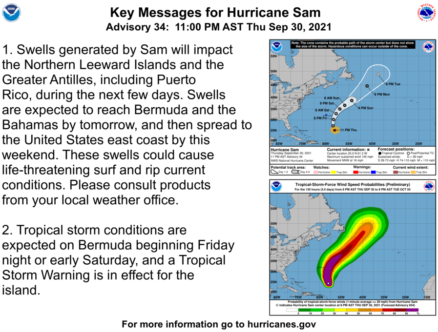
Key messages for Sam can be found in the Tropical Cyclone
Discussion under AWIPS header MIATCDAT3 and WMO header WTNT43 KNHC,
and on the web at hurricanes.gov/graphics_at3.shtml?key_messages.
WIND: Tropical storm conditions are possible on Bermuda beginning
Friday night or early Saturday.
SURF: Swells generated by Sam will impact the northern Leeward
Islands and the Greater Antilles, including Puerto Rico, during the
next few days. Swells are expected to reach Bermuda and the Bahamas
by Friday, and then spread to the United States east coast by this
weekend. These swells could cause life-threatening surf and rip
current conditions. Please consult products from your local
weather office.