BULLETIN
Tropical Depression Ten Advisory Number   2
NWS National Hurricane Center Miami FL       AL102019
500 PM AST Tue Sep 17 2019

...TROPICAL DEPRESSION MOVING WEST-NORTHWESTWARD...
...EXPECTED TO STRENGTHEN...


SUMMARY OF 500 PM AST...2100 UTC...INFORMATION
----------------------------------------------
LOCATION...13.4N 45.6W
ABOUT 1110 MI...1785 KM E OF THE LEEWARD ISLANDS
MAXIMUM SUSTAINED WINDS...35 MPH...55 KM/H
PRESENT MOVEMENT...WNW OR 290 DEGREES AT 10 MPH...17 KM/H
MINIMUM CENTRAL PRESSURE...1007 MB...29.74 INCHES


WATCHES AND WARNINGS
--------------------
There are no coastal watches or warnings in effect.

Interests in the northern Leeward Islands should monitor the
progress of this system.


DISCUSSION AND OUTLOOK
----------------------
At 500 PM AST (2100 UTC), the center of Tropical Depression Ten was
located near latitude 13.4 North, longitude 45.6 West. The
depression is moving toward the west-northwest near 10 mph
(17 km/h).  A west-northwestward motion at a somewhat faster forward
speed is expected over the next few days.  On the forecast track,
the system will be near the northern Leeward Islands Thursday night
or Friday.

Maximum sustained winds are near 35 mph (55 km/h) with higher gusts.
Strengthening is forecast during the next couple of days, and the
depression is expected to become a tropical storm tonight.  The
system is forecast become a hurricane by the time it moves near the
northern Leeward Islands.

The estimated minimum central pressure is 1007 mb (29.74 inches).
Monthly Archives: September 2019
Mr. Two-Bits for Tennessee game
Grant Holloway will serve as Mr. Two-Bits this week. His qualifications include:
-
110-meter Hurdles Collegiate Record Holder (12.98 – broke Renaldo Nehemiah’s 40-year-old record)
-
60-meter Hurdles American and Collegiate Record Holder (7.35 – No. 3 on world all-time list)
-
4×100 Relay Collegiate Record Holder (37.97)
-
2018-19 SEC Male Athlete of the Year
-
Two-time The Bowerman finalist (2018, 2019)
-
8-time NCAA Champion (school record)
-
6-time SEC Champion
Support for Feleipe Franks
Tropical Depression 10 – Advisory 1
BULLETIN
Tropical Depression Ten Advisory Number   1
NWS National Hurricane Center Miami FL       AL102019
1100 AM AST Tue Sep 17 2019

...TROPICAL DEPRESSION FORMS OVER THE CENTRAL TROPICAL ATLANTIC...


SUMMARY OF 1100 AM AST...1500 UTC...INFORMATION
-----------------------------------------------
LOCATION...12.9N 44.9W
ABOUT 1165 MI...1870 KM ESE OF THE LEEWARD ISLANDS
MAXIMUM SUSTAINED WINDS...35 MPH...55 KM/H
PRESENT MOVEMENT...WNW OR 295 DEGREES AT 12 MPH...19 KM/H
MINIMUM CENTRAL PRESSURE...1007 MB...29.74 INCHES


WATCHES AND WARNINGS
--------------------
There are no coastal watches or warnings in effect.

Interests in the Northern Leeward Islands should monitor the
progress of this system.


DISCUSSION AND OUTLOOK
----------------------
At 1100 AM AST (1500 UTC), the center of Tropical Depression Ten was
located near latitude 12.9 North, longitude 44.9 West. The
depression is moving toward the west-northwest near 12 mph (19
km/h). A west-northwestward motion at a somewhat faster forward
speed is expected over the next few days. On the forecast track,
the system will approach the northern Leeward Islands Thursday night
or Friday.

Maximum sustained winds are near 35 mph (55 km/h) with higher gusts.
Strengthening is forecast during the next couple of days, and the
depression is expected to become a tropical storm later today.  The
system is forecast become a hurricane by the time it approaches the
northern Leeward Island.

The estimated minimum central pressure is 1007 mb (29.74 inches).
Congrats, well deserved recognition.
Florida LB David Reese was named the SEC Defensive Player of Week, the conference announced on Monday.
Reese accumulated a career-high 16 tackles in Florida’s 29-21 victory over Kentucky on Saturday, leading all players in the statistic. The Farmington, Michigan, product made a critical stop to begin the fourth quarter, when he stuffed UK running back Asim Rose on fourth-and-one from the UF 38 yard line. The turnover on downs preceded a Gator touchdown drive and helped shift the game’s momentum.
Reese currently sits at fourth in SEC with 24 tackles on the season, four behind conference leader Cale Garrett of Missouri, according to cfbstats.com. Reese also leads all Gators in the category.
This is the second time Reese has received this honor. He was also named SEC Defensive Player of the Week following his 12-tackle performance in a 16-10 win at LSU in 2016.
🐊 Congratulations Coach Burleigh 🐊
With tonight’s win,  Head Coach @BeckyBurleigh earns her
 th career win!
 3rd all-time in NCAA D1
  history
2nd among NCAA D1 active coaches
1st woman NCAA D1 history with wins
🏈 What a game…..BIG WIN 🏈
The Florida Gators (3-0, 1-0) defeated the Kentucky Wildcats (2-1, 0-1) in come from behind fashion on Saturday in Lexington.
Quarterback Kyle Trask rallied the Gators from down 11 after he had to come in for an injured Feleipe Franks who was hurt in the third quarter.
Dodged this one !
Friday, 2pm Eastern – system stalled
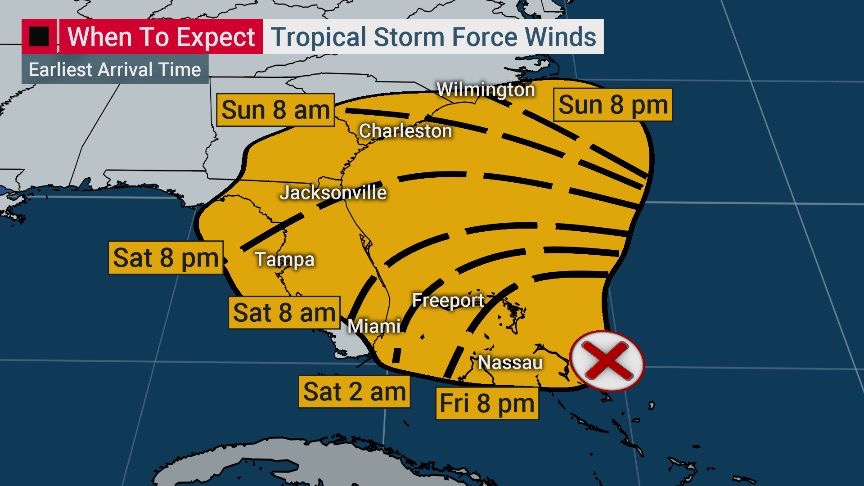
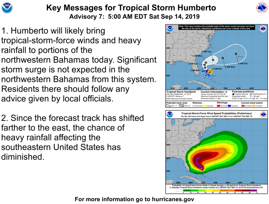
BULLETIN
Potential Tropical Cyclone Nine Intermediate Advisory Number 4A
NWS National Hurricane Center Miami FL       AL092019
200 PM EDT Fri Sep 13 2019

...DISTURBANCE FORECAST TO BECOME A TROPICAL DEPRESSION OR
TROPICAL STORM LATER TODAY...
...AIR FORCE PLANE STILL INVESTIGATING THE DISTURBANCE...


SUMMARY OF 200 PM EDT...1800 UTC...INFORMATION
----------------------------------------------
LOCATION...25.4N 74.2W
ABOUT 280 MI...450 KM ESE OF FREEPORT GRAND BAHAMA ISLAND
ABOUT 190 MI...305 KM ESE OF GREAT ABACO ISLAND
MAXIMUM SUSTAINED WINDS...30 MPH...45 KM/H
PRESENT MOVEMENT...STATIONARY
MINIMUM CENTRAL PRESSURE...1009 MB...29.80 INCHES


WATCHES AND WARNINGS
--------------------
CHANGES WITH THIS ADVISORY:

None.

SUMMARY OF WATCHES AND WARNINGS IN EFFECT:

A Tropical Storm Warning is in effect for...
* Northwestern Bahamas excluding Andros Island

A Tropical Storm Watch is in effect for...
* Jupiter Inlet to Flagler-Volusia County line

A Tropical Storm Warning means that tropical storm conditions are
expected somewhere within the warning area within 36 hours.

A Tropical Storm Watch means that tropical storm conditions are
possible within the watch area, generally within 48 hours.

Interests elsewhere along the east coast of Florida should monitor
the progress of this system.  Additional watches and warnings may
be required for portions of this area later today.

For storm information specific to your area in the United States,
including possible inland watches and warnings, please monitor
products issued by your local National Weather Service forecast
office. For storm information specific to your area outside of the
United States, please monitor products issued by your national
meteorological service.


DISCUSSION AND OUTLOOK
----------------------
At 200 PM EDT (1800 UTC), the disturbance was centered near latitude
25.4 North, longitude 74.2 West. The system has been meandering
during the past few hours, but is expected to resume a slow motion
toward the northwest and north-northwest later today. On the
forecast track, the system is anticipated to move across the central
and northwestern Bahamas tonight, and along or near the east coast
of Florida Saturday and Saturday night.

Maximum sustained winds are near 30 mph (45 km/h) with higher
gusts. Preliminary data from an Air Force Reconnaissance plane
indicate that the disturbance is becoming better organized, and
is anticipated that a tropical depression or a tropical storm
will likely form later today or tonight.

Environmental conditions are favorable for a tropical depression or
a tropical storm later today or tonight.
* Formation chance through 48 hours...high...90 percent
* Formation chance through 5 days... high...90 percent

The estimated minimum central pressure is 1009 mb (29.80 inches).


HAZARDS AFFECTING LAND
----------------------
WIND: Tropical storm conditions are expected within the warning
area in the northwestern Bahamas later today.  Tropical storm
conditions are possible in the watch area on the Florida peninsula
by Saturday or Saturday night.

RAINFALL: The potential tropical cyclone is expected to produce
total rainfall accumulations through Sunday:

The Bahamas...2 to 4 inches, isolated maximum amounts 6 inches.
The U.S. Southeast Coast from central Florida into South
Carolina...2 to 4 inches.

STORM SURGE: This system is not expected to product significant
storm surge in the northwestern Bahamas.
Never forget