Monthly Archives: September 2019
Gators chomped UT Martin
Florida opened the Swamp in grand fashion Saturday night. Despite a slow start, the Gators offense hummed as they amassed 543 yards and 45 points. Feleipe Franks was superb, completing 25/27 for 270 yards and a pair of touchdowns.
The redshirt junior signal caller completed passes to nine different receivers, and didn’t throw an incomplete pass until the final play of the first half, a jump ball heave to the endzone. Among his favorite targets, Van Jefferson and Tyrie Cleveland each hauled in long touchdowns that displayed touch and accuracy.
Going to the game?
Kickoff is at 7:32 pm, but make sure you’re in your seat in #TheSwamp for #MrTwoBits at 7:24 pm. #GoGators!
Thank You George

9am Advisory #44, Sept. 4
HURRICANE DORIAN FORECAST/ADVISORY NUMBER 44
NWS NATIONAL HURRICANE CENTER MIAMI FL AL052019
0900 UTC WED SEP 04 2019
CHANGES IN WATCHES AND WARNINGS WITH THIS ADVISORY…
THE GOVERNMENT OF THE BAHAMAS HAS DISCONTINUED ALL TROPICAL STORM
WARNINGS FOR THE BAHAMAS.
THE TROPICAL STORM WARNING SOUTH OF SEBASTIAN INLET FL HAS BEEN
DISCONTINUED.
THE HURRICANE WARNING FROM SEBASTIAN INLET FL TO THE
VOLUSIA/BREVARD COUNTY FL LINE IS CHANGED TO A TROPICAL STORM
WARNING.
SUMMARY OF WATCHES AND WARNINGS IN EFFECT…
A STORM SURGE WARNING IS IN EFFECT FOR…
* SEBASTIAN INLET FL TO SURF CITY NC
A STORM SURGE WATCH IS IN EFFECT FOR…
* NORTH OF SURF CITY NC TO POQUOSON VA…INCLUDING HAMPTON ROADS
* PAMLICO AND ALBEMARLE SOUNDS
* NEUSE AND PAMLICO RIVERS
A HURRICANE WARNING IS IN EFFECT FOR…
* VOLUSIA/BREVARD COUNTY FL LINE TO PONTE VEDRA BEACH FL
* NORTH OF SAVANNAH RIVER TO SURF CITY NC
A HURRICANE WATCH IS IN EFFECT FOR…
* NORTH OF PONTE VEDRA BEACH FL TO SAVANNAH RIVER
* NORTH OF SURF CITY NC TO THE NORTH CAROLINA/VIRGINIA BORDER
* ALBEMARLE AND PAMLICO SOUNDS
A TROPICAL STORM WARNING IS IN EFFECT FOR…
* SEBASTIAN INLET…FL TO THE VOLUSIA/BREVARD COUNTY FL LINE
* NORTH OF PONTE VEDRA BEACH FL TO SAVANNAH RIVER
A TROPICAL STORM WATCH IS IN EFFECT FOR…
* THE NORTH CAROLINA/VIRGINIA BORDER TO CHINCOTEAGUE VA
* CHESAPEAKE BAY FROM SMITH POINT SOUTHWARD
A STORM SURGE WARNING MEANS THERE IS A DANGER OF LIFE-THREATENING
INUNDATION…FROM RISING WATER MOVING INLAND FROM THE
COASTLINE…DURING THE NEXT 36 HOURS IN THE INDICATED LOCATIONS.
FOR A DEPICTION OF AREAS AT RISK…PLEASE SEE THE NATIONAL WEATHER
SERVICE STORM SURGE WATCH/WARNING GRAPHIC…AVAILABLE AT
HURRICANES.GOV. THIS IS A LIFE-THREATENING SITUATION. PERSONS
LOCATED WITHIN THESE AREAS SHOULD TAKE ALL NECESSARY ACTIONS TO
PROTECT LIFE AND PROPERTY FROM RISING WATER AND THE POTENTIAL FOR
OTHER DANGEROUS CONDITIONS. PROMPTLY FOLLOW EVACUATION AND OTHER
INSTRUCTIONS FROM LOCAL OFFICIALS.
A STORM SURGE WATCH MEANS THERE IS A POSSIBILITY OF LIFE-
THREATENING INUNDATION…FROM RISING WATER MOVING INLAND FROM THE
COASTLINE…IN THE INDICATED LOCATIONS DURING THE NEXT 48 HOURS.
A HURRICANE WARNING MEANS THAT HURRICANE CONDITIONS ARE EXPECTED
SOMEWHERE WITHIN THE WARNING AREA. PREPARATIONS TO PROTECT LIFE AND
PROPERTY SHOULD BE RUSHED TO COMPLETION.
A HURRICANE WATCH MEANS THAT HURRICANE CONDITIONS ARE POSSIBLE
WITHIN THE WATCH AREA. A WATCH IS TYPICALLY ISSUED 48 HOURS
BEFORE THE ANTICIPATED FIRST OCCURRENCE OF TROPICAL-STORM-FORCE
WINDS…CONDITIONS THAT MAKE OUTSIDE PREPARATIONS DIFFICULT OR
DANGEROUS.
A TROPICAL STORM WARNING MEANS THAT TROPICAL STORM CONDITIONS ARE
EXPECTED WITHIN THE WARNING AREA WITHIN 36 HOURS.
A TROPICAL STORM WATCH MEANS THAT TROPICAL STORM CONDITIONS ARE
POSSIBLE WITHIN THE WATCH AREA…GENERALLY WITHIN 48 HOURS.
INTERESTS ELSEWHERE ALONG THE MID-ATLANTIC COAST OF THE UNITED
STATES SHOULD CONTINUE TO MONITOR THE PROGRESS OF DORIAN…AS
ADDITIONAL WATCHES OR WARNINGS MAY BE REQUIRED LATER TODAY.
HURRICANE CENTER LOCATED NEAR 29.2N 79.5W AT 04/0900Z
POSITION ACCURATE WITHIN 20 NM
PRESENT MOVEMENT TOWARD THE NORTH-NORTHWEST OR 330 DEGREES AT 7 KT
ESTIMATED MINIMUM CENTRAL PRESSURE 963 MB
MAX SUSTAINED WINDS 90 KT WITH GUSTS TO 110 KT.
64 KT……. 50NE 40SE 30SW 50NW.
50 KT…….100NE 70SE 50SW 90NW.
34 KT…….150NE 130SE 100SW 140NW.
12 FT SEAS..240NE 180SE 150SW 210NW.
WINDS AND SEAS VARY GREATLY IN EACH QUADRANT. RADII IN NAUTICAL
MILES ARE THE LARGEST RADII EXPECTED ANYWHERE IN THAT QUADRANT.
REPEAT…CENTER LOCATED NEAR 29.2N 79.5W AT 04/0900Z
AT 04/0600Z CENTER WAS LOCATED NEAR 28.8N 79.2W
FORECAST VALID 04/1800Z 30.1N 79.8W
MAX WIND 90 KT…GUSTS 110 KT.
64 KT… 50NE 50SE 40SW 50NW.
50 KT…100NE 70SE 60SW 90NW.
34 KT…160NE 140SE 100SW 140NW.
FORECAST VALID 05/0600Z 31.2N 80.0W
MAX WIND 90 KT…GUSTS 110 KT.
64 KT… 50NE 50SE 40SW 50NW.
50 KT… 80NE 80SE 60SW 80NW.
34 KT…160NE 140SE 100SW 130NW.
FORECAST VALID 05/1800Z 32.2N 79.4W
MAX WIND 85 KT…GUSTS 105 KT.
64 KT… 50NE 50SE 40SW 50NW.
50 KT… 80NE 80SE 60SW 70NW.
34 KT…160NE 150SE 110SW 100NW.
FORECAST VALID 06/0600Z 33.7N 77.7W
MAX WIND 80 KT…GUSTS 100 KT.
64 KT… 50NE 50SE 40SW 50NW.
50 KT… 80NE 80SE 60SW 70NW.
34 KT…160NE 160SE 120SW 90NW.
FORECAST VALID 07/0600Z 38.0N 70.6W
MAX WIND 75 KT…GUSTS 90 KT.
50 KT…100NE 100SE 80SW 80NW.
34 KT…220NE 200SE 180SW 170NW.
EXTENDED OUTLOOK. NOTE…ERRORS FOR TRACK HAVE AVERAGED NEAR 150 NM
ON DAY 4 AND 175 NM ON DAY 5…AND FOR INTENSITY NEAR 15 KT EACH DAY
OUTLOOK VALID 08/0600Z 45.0N 61.5W…POST-TROP/EXTRATROP
MAX WIND 70 KT…GUSTS 85 KT.
OUTLOOK VALID 09/0600Z 53.5N 50.0W…POST-TROP/EXTRATROP
MAX WIND 60 KT…GUSTS 75 KT.
REQUEST FOR 3 HOURLY SHIP REPORTS WITHIN 300 MILES OF 29.2N 79.5W
INTERMEDIATE PUBLIC ADVISORY…WTNT35 KNHC/MIATCPAT5…AT 04/1200Z
Advisory #41 9/3 11am
BULLETIN
Hurricane Dorian Advisory Number 41
NWS National Hurricane Center Miami FL AL052019
1100 AM EDT Tue Sep 03 2019
…DORIAN FINALLY MOVING NORTHWESTWARD AND GROWING IN SIZE…
…DANGEROUS WINDS AND LIFE-THREATENING STORM SURGE CONTINUES ON
GRAND BAHAMA ISLAND…
SUMMARY OF 1100 AM EDT…1500 UTC…INFORMATION
———————————————–
LOCATION…27.1N 78.6W
ABOUT 45 MI…70 KM N OF FREEPORT GRAND BAHAMA ISLAND
ABOUT 105 MI…170 KM E OF FORT PIERCE FLORIDA
MAXIMUM SUSTAINED WINDS…110 MPH…175 KM/H
PRESENT MOVEMENT…NW OR 320 DEGREES AT 2 MPH…4 KM/H
MINIMUM CENTRAL PRESSURE…955 MB…28.20 INCHES
WATCHES AND WARNINGS
——————–
CHANGES WITH THIS ADVISORY:
The Storm Surge Warning has been extended northward to South Santee
River, South Carolina.
The Storm Surge Watch has been extended northward to Cape Lookout,
North Carolina.
A Hurricane Warning has been issued for the coast of South Carolina
from north of Edisto Beach to the South Santee River.
A Hurricane Watch has been issued from north of South Santee River
to Duck, North Carolina, including the Pamlico and Albemarle Sounds.
The Tropical Storm Warning has been extended north to Edisto Beach,
South Carolina.
The Storm Surge Warning has been discontinued south of Jupiter
Inlet, Florida.
The Storm Surge Watch has been discontinued south of Lantana,
Florida has been discontinued.
The Hurricane Watch from Deerfield Beach to Jupiter Inlet has
been discontinued.
The Tropical Storm Watch from Golden Beach to Deerfield Beach has
been discontinued.
SUMMARY OF WATCHES AND WARNINGS IN EFFECT:
A Storm Surge Warning is in effect for…
* Jupiter Inlet FL to South Santee River SC
A Storm Surge Watch is in effect for…
* North of South Santee River SC to Cape Lookout NC
A Hurricane Warning is in effect for…
* Grand Bahama and the Abacos Islands in the northwestern Bahamas
* Jupiter Inlet FL to Ponte Vedra Beach FL
* North of Edisto Beach SC to South Santee River SC
A Hurricane Watch is in effect for…
* North of Ponte Vedra Beach FL to Edisto Beach SC
* North of South Santee River SC to Duck NC
* Albemarle and Pamlico Sounds
A Tropical Storm Warning is in effect for…
* North of Deerfield Beach FL to Jupiter Inlet FL
* North of Ponte Vedra Beach FL to Edisto Beach SC
A Tropical Storm Watch is in effect for…
* Lake Okeechobee
A Storm Surge Warning means there is a danger of life-threatening
inundation, from rising water moving inland from the coastline,
during the next 36 hours in the indicated locations. For a depiction
of areas at risk, please see the National Weather Service Storm
Surge Watch/Warning Graphic, available at hurricanes.gov. This is a
life-threatening situation. Persons located within these areas
should take all necessary actions to protect life and property from
rising water and the potential for other dangerous conditions.
Promptly follow evacuation and other instructions from local
officials.
A Storm Surge Watch means there is a possibility of life-
threatening inundation, from rising water moving inland from the
coastline, in the indicated locations during the next 48 hours.
A Hurricane Warning means that hurricane conditions are expected
somewhere within the warning area. Preparations to protect life and
property should be rushed to completion.
A Hurricane Watch means that hurricane conditions are possible
within the watch area. A watch is typically issued 48 hours
before the anticipated first occurrence of tropical-storm-force
winds, conditions that make outside preparations difficult or
dangerous.
A Tropical Storm Warning means that tropical storm conditions are
expected within the warning area within 36 hours.
A Tropical Storm Watch means that tropical storm conditions are
possible within the watch area, generally within 48 hours.
Interests elsewhere along the southeast and Mid-Atlantic coasts of
the United States should continue to monitor the progress of Dorian,
as additional watches or warnings may be required today.
For storm information specific to your area in the United
States, including possible inland watches and warnings, please
monitor products issued by your local National Weather Service
forecast office. For storm information specific to your area
outside of the United States, please monitor products issued by
your national meteorological service.
DISCUSSION AND OUTLOOK
———————-
At 1100 AM EDT (1500 UTC), the eye of Hurricane Dorian was
located near latitude 27.1 North, longitude 78.6 West. Dorian is
moving toward the northwest near 2 mph (4 km/h), and a slightly
faster motion toward the northwest or north-northwest is expected
later today and tonight. A turn toward the north is forecast by
Wednesday evening, followed by a turn toward the north-northeast
Thursday morning. On this track, the core of extremely dangerous
Hurricane Dorian will gradually move north of Grand Bahama Island
through this evening. The hurricane will then move dangerously
close to the Florida east coast late today through Wednesday
evening, very near the Georgia and South Carolina coasts Wednesday
night and Thursday, and near or over the North Carolina coast late
Thursday and Thursday night.
Data from reconnaissance aircraft indicate that the maximum
sustained winds are near 110 mph (175 km/h) with higher gusts.
Dorian is expected to remain a powerful hurricane during the next
couple of days.
Data from aircraft and buoys indicate that the hurricane is growing
in size. Hurricane-force winds extend outward up to 60 miles (95
km) from the center and tropical-storm-force winds extend outward up
to 175 miles (280 km).
The latest minimum central pressure based on data from Air Force
Reserve and NOAA reconnaissance aircraft is 955 mb (28.20 inches).
HAZARDS AFFECTING LAND
———————-
WIND: Tropical storm and hurricane conditions will continue on
Grand Bahama Island through tonight.
Hurricane conditions are expected within the Hurricane Warning area
in Florida by this evening. Hurricane conditions are possible in
the Hurricane Watch area as early as Wednesday and could spread
northward within the watch through Thursday.
In South Florida, tropical storm conditions are expected within the
Tropical Storm Warning area through today. Along the coast of
northeastern Florida and Georgia, tropical storm conditions are
expected within the Tropical Storm Warning area on Wednesday.
STORM SURGE: A life-threatening storm surge will raise water levels
by as much as 10 to 15 feet above normal tide levels in areas of
onshore winds on Grand Bahama Island. Near the coast, the surge
will be accompanied by large and destructive waves. Water levels
should very slowly subside on the Abaco Islands today.
The combination of a dangerous storm surge and the tide will cause
normally dry areas near the coast to be flooded by rising waters
moving inland from the shoreline. The water could reach the
following heights above ground somewhere in the indicated areas if
the peak surge occurs at the time of high tide…
Flagler/Volusia County Line FL to Cape Lookout NC…4 to 7 ft
Jupiter Inlet FL to the Flagler/Volusia County Line FL…3 to 5 ft
Water levels could begin to rise well in advance of the arrival of
strong winds. The surge will be accompanied by large and
destructive waves. Surge-related flooding depends on the how close
the center of Dorian comes to the coast, and can vary greatly over
short distances. For information specific to your area, please see
products issued by your local National Weather Service forecast
office.
RAINFALL: Dorian is expected to produce the following rainfall
totals through Friday:
Northwestern Bahamas…Additional 2 to 4 inches, isolated storm
totals over 30 inches.
Coastal Carolinas…5 to 10 inches, isolated 15 inches.
Atlantic Coast from the Florida peninsula north of West Palm Beach
through Georgia…3 to 6 inches, isolated 9 inches.
Southeast Virginia…2 to 4 inches, isolated 6 inches.
This rainfall may cause life-threatening flash floods.
SURF: Large swells are affecting the northwestern Bahamas, the
Florida east coast, and the coast of Georgia. These swells are
expected to spread northward along much of the remainder of the
southeastern United States coast during the next couple of days.
These swells are likely to cause life-threatening surf and rip
current conditions. Please consult products from your local weather
office.
TORNADOES: A tornado or two are possible near the immediate east
coast of Florida through tonight. This risk will shift to along
the immediate coastal Georgia and the coastal Carolinas on Wednesday
into Thursday
Hurricane Advisory 9/01 – 11pm
BULLETIN Hurricane Dorian Advisory Number 35 NWS National Hurricane Center Miami FL AL052019 1100 PM EDT Sun Sep 01 2019 …CATASTROPHIC CATEGORY 5 DORIAN MAKES LANDFALL ON THE EASTERN END OF GRAND BAHAMA ISLAND… SUMMARY OF 1100 PM EDT…0300 UTC…INFORMATION ———————————————– LOCATION…26.6N 77.9W ABOUT 55 MI…90 KM E OF FREEPORT GRAND BAHAMA ISLAND ABOUT 135 MI…220 KM E OF WEST PALM BEACH FLORIDA MAXIMUM SUSTAINED WINDS…180 MPH…285 KM/H PRESENT MOVEMENT…W OR 275 DEGREES AT 6 MPH…9 KM/H MINIMUM CENTRAL PRESSURE…914 MB…26.99 INCHES WATCHES AND WARNINGS ——————– CHANGES WITH THIS ADVISORY: A Hurricane Watch has been extended northward from the Flagler/Volusia County Line to the Mouth of the St. Mary’s River. A Storm Surge Watch has also been extended northward from the Flagler/Volusia County Line to the Mouth of the St. Mary’s River.
SUMMARY OF WATCHES AND WARNINGS IN EFFECT: A Storm Surge Warning is in effect for… * Lantana to the Volusia/Brevard County Line A Storm Surge Watch is in effect for… * North of Deerfield Beach to Lantana * Volusia/Brevard County Line to the Mouth of the St. Mary’s River A Hurricane Warning is in effect for… * Northwestern Bahamas excluding Andros Island * Jupiter Inlet to the Volusia/Brevard County Line A Hurricane Watch is in effect for… * Andros Island * North of Deerfield Beach to Jupiter Inlet * Volusia/Brevard County Line to the Mouth of the St. Mary’s River A Tropical Storm Warning is in effect for… * North of Deerfield Beach to Jupiter Inlet A Tropical Storm Watch is in effect for… * North of Golden Beach to Deerfield Beach * Lake Okeechobee A Storm Surge Warning means there is a danger of life-threatening inundation, from rising water moving inland from the coastline, during the next 36 hours in the indicated locations. For a depiction of areas at risk, please see the National Weather Service Storm Surge Watch/Warning Graphic, available at hurricanes.gov. This is a life-threatening situation. Persons located within these areas should take all necessary actions to protect life and property from rising water and the potential for other dangerous conditions. Promptly follow evacuation and other instructions from local officials. A Storm Surge Watch means there is a possibility of life- threatening inundation, from rising water moving inland from the coastline, in the indicated locations during the next 48 hours. A Hurricane Warning means that hurricane conditions are expected somewhere within the warning area. Preparations to protect life and property should be rushed to completion. A Hurricane Watch means that hurricane conditions are possible within the watch area. A watch is typically issued 48 hours before the anticipated first occurrence of tropical-storm-force winds, conditions that make outside preparations difficult or dangerous. A Tropical Storm Warning means that tropical storm conditions are expected within the warning area within 36 hours. A Tropical Storm Watch means that tropical storm conditions are possible within the watch area, generally within 48 hours. Interests elsewhere along the east coast of Florida should continue to monitor the progress of Dorian, as additional watches or warnings may be required later today. For storm information specific to your area in the United States, including possible inland watches and warnings, please monitor products issued by your local National Weather Service forecast office. For storm information specific to your area outside of the United States, please monitor products issued by your national meteorological service.
DISCUSSION AND OUTLOOK ———————- At 1100 PM EDT (0300 UTC), the center of Hurricane Dorian was located near latitude 26.6 North, longitude 77.9 West. Dorian is moving toward the west near 6 mph (9 km/h). A slower westward to west-northwestward motion is forecast during the next day or so, followed by a gradual turn toward the northwest. On this track, the core of extremely dangerous Hurricane Dorian will continue to pound Great Abaco and Grand Bahama islands overnight and through much of Monday. The hurricane will move dangerously close to the Florida east coast late Monday through Tuesday night. Maximum sustained winds are near 180 mph (285 km/h) with higher gusts. Dorian is a category 5 hurricane on the Saffir-Simpson Hurricane Wind Scale. Slow weakening is forecast, but fluctuations in intensity could occur couple of days. Regardless, Dorian is expected to remain a powerful hurricane during the next few days. Hurricane-force winds extend outward up to 45 miles (75 km) from the center and tropical-storm-force winds extend outward up to 140 miles (220 km). The estimated minimum central pressure is 914 mb (26.99 inches).
HAZARDS AFFECTING LAND ———————- WIND: Catastrophic hurricane conditions continue in the Abacos and Grand Bahama Islands. Do not venture out into the eye, as winds will suddenly increase as the eye passes. Hurricane conditions are expected within the hurricane warning area in Florida by late Monday or Tuesday. Tropical storm conditions are expected within the tropical storm warning area on Monday and Tuesday and are possible in the tropical storm watch area by Monday night. STORM SURGE: A life-threatening storm surge will raise water levels by as much as 18 to 23 feet above normal tide levels in areas of onshore winds on the Abaco Islands and Grand Bahama Island. Near the coast, the surge will be accompanied by large and destructive waves. The combination of a dangerous storm surge and the tide will cause normally dry areas near the coast to be flooded by rising waters moving inland from the shoreline. The water could reach the following heights above ground somewhere in the indicated areas if the peak surge occurs at the time of high tide… Lantana to the Mouth of the St. Mary’s River…4 to 7 ft North of Deerfield Beach to Lantana FL…2 to 4 ft The surge will be accompanied by large and destructive waves. Surge-related flooding depends on the how close the center of Dorian comes to the Florida east coast, and can vary greatly over short distances. For information specific to your area, please see products issued by your local National Weather Service forecast office. RAINFALL: Dorian is expected to produce the following rainfall totals through late this week: Northwestern Bahamas…12 to 24 inches, isolated 30 inches. Coastal Carolinas…5 to 10 inches, isolated 15 inches. The Atlantic Coast from the Florida peninsula through Georgia…3 to 6 inches, isolated 9 inches. Southeastern Virginia…2 to 4 inches, isolated 6 inches. Central Bahamas…2 to 4 inches, isolated 6 inches. This rainfall may cause life-threatening flash floods. SURF: Large swells are affecting east-facing shores of the Bahamas and the Florida east coast, and will spread northward along the southeastern United States coast during the next few days. These swells are likely to cause life-threatening surf and rip current conditions. Please consult products from your local weather office.
Corrected Hurricane Advisory – 5pm 9/1
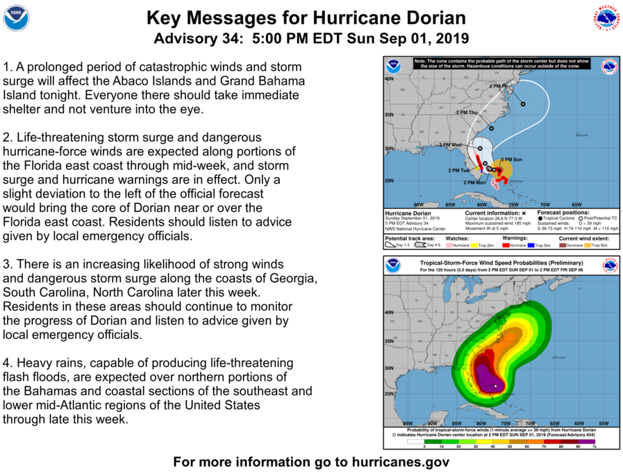
BULLETIN
Hurricane Dorian Advisory Number  34...Corrected
NWS National Hurricane Center Miami FL       AL052019
500 PM EDT Sun Sep 01 2019

Corrected to modify Storm Surge section

...EYE OF CATASTROPHIC HURRICANE DORIAN CRAWLING OVER THE ABACOS
ISLANDS IN THE BAHAMAS...
...DORIAN'S FURY NOW AIMING TOWARD GRAND BAHAMA...


SUMMARY OF 500 PM EDT...2100 UTC...INFORMATION
----------------------------------------------
LOCATION...26.6N 77.3W
ABOUT 95 MI...150 KM E OF FREEPORT GRAND BAHAMA ISLAND
ABOUT 175 MI...280 KM E OF WEST PALM BEACH FLORIDA
MAXIMUM SUSTAINED WINDS...185 MPH...295 KM/H
PRESENT MOVEMENT...W OR 270 DEGREES AT 5 MPH...7 KM/H
MINIMUM CENTRAL PRESSURE...910 MB...26.88 INCHES


WATCHES AND WARNINGS
--------------------
CHANGES WITH THIS ADVISORY:

A Storm Surge Warning has been issued from Lantana to the
Volusia/Brevard County Line.

A Storm Surge Watch has been issued from the Volusia/Brevard County
Line to the Flagler/Volusia County Line.

A Hurricane Warning has been issued from Jupiter Inlet to the
Volusia/Brevard County Line.

A Hurricane Watch has been issued from the Volusia/Brevard County
Line to the Flagler/Volusia County Line

SUMMARY OF WATCHES AND WARNINGS IN EFFECT:

A Storm Surge Warning is in effect for...
* Lantana to the Volusia/Brevard County Line

A Storm Surge Watch is in effect for...
* North of Deerfield Beach to Lantana
* Volusia/Brevard County Line to the Flagler/Volusia County Line

A Hurricane Warning is in effect for...
* Northwestern Bahamas excluding Andros Island
* Jupiter Inlet to the Volusia/Brevard County Line

A Hurricane Watch is in effect for...
* Andros Island
* North of Deerfield Beach to Jupiter Inlet
* Volusia/Brevard County Line to the Flagler/Volusia County Line

A Tropical Storm Warning is in effect for...
* North of Deerfield Beach to Jupiter Inlet

A Tropical Storm Watch is in effect for...
* North of Golden Beach to Deerfield Beach
* Lake Okeechobee


Interests elsewhere along the east coast of Florida should continue
to monitor the progress of Dorian, as additional watches or
warnings may be required later today.

For storm information specific to your area in the United
States, including possible inland watches and warnings, please
monitor products issued by your local National Weather Service
forecast office. For storm information specific to your area
outside of the United States, please monitor products issued by
your national meteorological service.


DISCUSSION AND OUTLOOK
----------------------
At 500 PM EDT (2100 UTC), the distinct eye of Hurricane Dorian was
located near latitude 26.6 North, longitude 77.3 West. Dorian is
moving toward the west near 5 mph (7 km/h). A slower westward
to west-northwestward motions should continue for the next day or
two, followed by a gradual turn toward the northwest.  On this
track, the core of extremely dangerous Hurricane Dorian will
continue to pound Great Abaco this evening and move near or
over Grand Bahama Island tonight and Monday. The hurricane will
move dangerously close to the Florida east coast late Monday through
Tuesday night.

Maximum sustained winds are near 185 mph (295 km/h) with higher
gusts.  Dorian is a category 5 hurricane on the Saffir-Simpson
Hurricane Wind Scale.  Some fluctuations in intensity are likely,
and Dorian is expected to remain a catastrophic hurricane during the
next few days.

Hurricane-force winds extend outward up to 45 miles (75 km) from the
center and tropical-storm-force winds extend outward up to 140 miles
(220 km).

The last minimum central pressure measured by an Air Force
reconnaissance plane a couple of hours ago was 910 mb (26.88
inches).


HAZARDS AFFECTING LAND
----------------------
WIND:  Catastrophic hurricane conditions are occurring in the Abacos
Islands and will spread across Grand Bahama Island tonight. Do not
venture out into the eye, as winds will suddenly increase as the eye
passes.

Hurricane conditions are expected within the hurricane warning area
in Florida by late Monday or Tuesday.

Tropical storm conditions are expected within the tropical storm
warning area on Monday and Tuesday and are possible in the tropical
storm watch area by Monday night.

STORM SURGE:  A life-threatening storm surge will raise water levels
by as much as 18 to 23 feet above normal tide levels in areas of
onshore winds on the Abaco Islands and Grand Bahama Island.  Near
the coast, the surge will be accompanied by large and destructive
waves.

The combination of a dangerous storm surge and the tide will cause
normally dry areas near the coast to be flooded by rising waters
moving inland from the shoreline. The water could reach the
following heights above ground somewhere in the indicated
areas if the peak surge occurs at the time of high tide...

Flagler/Volusia County Line to Lantana FL...4 to 7 ft
North of Deerfield Beach to Lantana FL...2 to 4 ft

The surge will be accompanied by large and destructive waves.
Surge-related flooding depends on the how close the center of
Dorian comes to the Florida east coast, and can vary greatly over
short distances.  For information specific to your area, please see
products issued by your local National Weather Service forecast
office.

RAINFALL:  Dorian is expected to produce the following rainfall
totals through late this week:

Northwestern Bahamas...12 to 24 inches, isolated 30 inches.
Coastal Carolinas...5 to 10 inches, isolated 15 inches.
The Atlantic Coast from the Florida peninsula through Georgia...3 to
6 inches, isolated 9 inches.
Southeastern Virginia...2 to 4 inches, isolated 6 inches.
Central Bahamas...2 to 4 inches, isolated 6 inches.

This rainfall may cause life-threatening flash floods.

SURF:  Large swells are already affecting east-facing shores of the
Bahamas, the Florida east coast, and will spread northward along the
southeastern United States coast during the next few days.  These
swells are likely to cause life-threatening surf and rip current
conditions.  Please consult products from your local weather office.
Key Messages 9/1 5pm
9/1 Special Update (12:45)
Hurricane Dorian Tropical Cyclone Update
NWS National Hurricane Center Miami FL AL052019
1245 pm EDT Sun Sep 01 2019
…CATASTROPHIC CATEGORY 5 DORIAN MAKES LANDFALL ON ELBOW CAY IN THE
ABACOS…
Data from an Air Force Reserve Hurricane Hunter aircraft and
satellite data indicate that Dorian has made landfall at 1240 pm
EDT (1640 UTC) in Elbow Cay, Abacos. The winds have increased
to 185 mph (295 km/h) with the minimum central pressure falling to
911 mb (26.90 inches).
This is a life-threatening situation. Residents there should take
immediate shelter. Do not venture into the eye if it passes over
your location.
Hazards:
– Wind Gusts over 220 mph
– Storm Surge 18 to 23 feet above normal tide levels with higher
destructive waves
These hazards will cause extreme destruction in the affected areas
and will continue for several hours.
SUMMARY OF 1245 PM EDT…1645 UTC…INFORMATION
———————————————-
LOCATION…26.5N 77.0W
ABOUT 5 MI…10 KM E OF GREAT ABACO ISLAND
MAXIMUM SUSTAINED WINDS…185 MPH…295 KM/H
PRESENT MOVEMENT…W OR 275 DEGREES AT 8 MPH…13 KM/H
MINIMUM CENTRAL PRESSURE…911 MB…26.90 INCHES