GAINESVILLE, Fla. (WCJB) – In a 3 to 2 vote, the Alachua County Commission decided to end their ordinance requiring the use of face masks in public spaces in the county.
Commissioners Byerly, Cornell, and Chestnut voted to eliminate the ordinance, while Commissioners Warren and Chairman Hutchinson voted to keep it in place.
On May 1, the Commission had voted to enact an ordinance requiring face coverings in interior public spaces, like businesses. The order came shortly after the Governor announced the phased reopening of the State.
According to the Gainesville Police Department and the Alachua County Sheriff’s Office, no citations have been issued for lack of facial coverings.
The NCAA Division I Council, could lift a nation-wide moratorium on on-campus summer activities, creating a pathway for schools to welcome back their athletes as soon as June 1. The ban, triggered in March amid the coronavirus outbreak, expires May 31.
The SEC Presidents will vote on Friday (May 22) whether you allow student athletes back on campus either June 1 or June 15. Obviously that vote will be contingent on the vote Wednesday.
BULLETIN
Tropical Storm Arthur Advisory Number  11
NWS National Hurricane Center Miami FL       AL012020
500 AM EDT Tue May 19 2020

...ARTHUR EXPECTED TO BECOME POST TROPICAL LATER TODAY...


SUMMARY OF 500 AM EDT...0900 UTC...INFORMATION
----------------------------------------------
LOCATION...37.0N 70.6W
ABOUT 300 MI...485 KM ENE OF CAPE HATTERAS NORTH CAROLINA
MAXIMUM SUSTAINED WINDS...60 MPH...95 KM/H
PRESENT MOVEMENT...ENE OR 75 DEGREES AT 15 MPH...24 KM/H
MINIMUM CENTRAL PRESSURE...991 MB...29.27 INCHES


WATCHES AND WARNINGS
--------------------
There are no coastal watches or warnings in effect.


DISCUSSION AND OUTLOOK
----------------------
At 500 AM EDT (0900 UTC), the center of Tropical Storm Arthur was
located near latitude 37.0 North, longitude 70.6 West. Arthur is
moving toward the east-northeast near 15 mph (24 km/h). A turn
toward the east is expected this morning. Arthur is then forecast
to slow down and turn toward the south in another day or so.

Maximum sustained winds are near 60 mph (95 km/h) with higher gusts.
Arthur is forecast to become post-tropical later today. Slight
strengthening is possible this morning, but a general weakening
trend is expected to begin by Wednesday.  Arthur is expected to
dissipate by the end of the week.

Tropical-storm-force winds extend outward up to 140 miles (220 km)
from the center.

The estimated minimum central pressure is 991 mb (29.27 inches).


HAZARDS AFFECTING LAND
----------------------
SURF:  Swells generated by Arthur are expected to affect portions
of the mid-Atlantic and southeast U.S. coasts during the next
day or two.  These swells could cause life-threatening surf and rip
current conditions. Please consult products from your local weather
office.


NEXT ADVISORY
-------------
Next complete advisory at 1100 AM EDT.
WTNT31 KNHC 182039
TCPAT1

BULLETIN
Tropical Storm Arthur Advisory Number   9
NWS National Hurricane Center Miami FL       AL012020
500 PM EDT Mon May 18 2020

...ARTHUR CONTINUES TO MOVE AWAY FROM THE NORTH CAROLINA OUTER
BANKS...


SUMMARY OF 500 PM EDT...2100 UTC...INFORMATION
----------------------------------------------
LOCATION...36.1N 73.9W
ABOUT 110 MI...175 KM NE OF CAPE HATTERAS NORTH CAROLINA
MAXIMUM SUSTAINED WINDS...50 MPH...85 KM/H
PRESENT MOVEMENT...NE OR 45 DEGREES AT 16 MPH...26 KM/H
MINIMUM CENTRAL PRESSURE...993 MB...29.33 INCHES


WATCHES AND WARNINGS
--------------------
CHANGES WITH THIS ADVISORY:

All Tropical Storm Warnings have been discontinued.

SUMMARY OF WATCHES AND WARNINGS IN EFFECT:

There are no coastal watches or warnings in effect.

For storm information specific to your area, including possible
inland watches and warnings, please monitor products issued by your
local National Weather Service forecast office.


DISCUSSION AND OUTLOOK
----------------------
At 500 PM EDT (2100 UTC), the center of Tropical Storm Arthur was
located near latitude 36.1 North, longitude 73.9 West. Arthur is
moving toward the northeast near 16 mph (26 km/h). A turn toward
the east-northeast is expected tonight, followed by a turn
toward the east on Tuesday.  A slower southeast or south-southeast
motion is expected to begin Tuesday night and continue through
Wednesday. On the forecast track, the center of Arthur will
continue to move away from the east coast of the United States.

Maximum sustained winds are near 50 mph (85 km/h) with higher gusts.
While some strengthening is forecast during the next 24 hours,
Arthur is likely to lose its tropical characteristics late by
tonight or Tuesday.

Tropical-storm-force winds extend outward up to 115 miles (185 km)
primarily to the east of the center. NOAA Buoy 44014 located about
50 miles north west of Arthur's center recently measured a
sustained wind of 38 mph (61 km/h) and a gust to 45 mph (72 km/h).

The estimated minimum central pressure is 993 mb (29.33 inches).


HAZARDS AFFECTING LAND
----------------------
SURF:  Swells generated by Arthur are expected to affect portions
of the mid-Atlantic and southeast U.S. coasts during the next
day or two.  These swells could cause life-threatening surf and rip
current conditions. Please consult products from your local weather
office.
WTNT31 KNHC 181441
TCPAT1
BULLETIN
Tropical Storm Arthur Advisory Number 8
NWS National Hurricane Center Miami FL AL012020
1100 AM EDT Mon May 18 2020
...CENTER OF ARTHUR PASSING JUST SOUTHEAST OF CAPE HATTERAS...
...STORM BRINGING HEAVY RAINFALL AND GUSTY WINDS TO PORTIONS OF
EASTERN NORTH CAROLINA...
SUMMARY OF 1100 AM EDT...1500 UTC...INFORMATION
-----------------------------------------------
LOCATION...35.1N 75.2W
ABOUT 20 MI...30 KM ESE OF CAPE HATTERAS NORTH CAROLINA
MAXIMUM SUSTAINED WINDS...50 MPH...85 KM/H
PRESENT MOVEMENT...NNE OR 30 DEGREES AT 16 MPH...26 KM/H
MINIMUM CENTRAL PRESSURE...996 MB...29.42 INCHES
WATCHES AND WARNINGS
--------------------
CHANGES WITH THIS ADVISORY:
None.
SUMMARY OF WATCHES AND WARNINGS IN EFFECT:
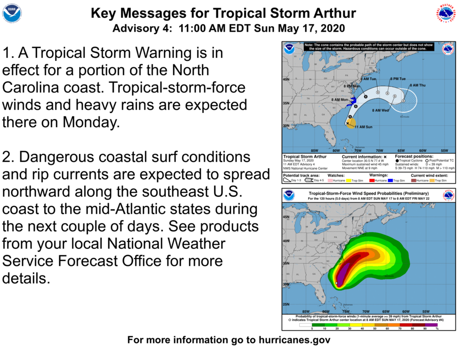
A Tropical Storm Warning is in effect for...
* Surf City to Duck NC
* Pamlico and Albemarle Sounds
A Tropical Storm Warning means that tropical storm conditions are
expected somewhere within the warning area.
For storm information specific to your area, including possible
inland watches and warnings, please monitor products issued by your
local National Weather Service forecast office.
DISCUSSION AND OUTLOOK
----------------------
At 1100 AM EDT (1500 UTC), the center of Tropical Storm Arthur was
located near latitude 35.1 North, longitude 75.2 West. Arthur is
moving toward the north-northeast near 16 mph (26 km/h). A turn
toward the northeast is expected later today, followed by a turn
toward the east on Tuesday. A slower southeast or south-southeast
motion is forecast to begin Tuesday night and continue through
Wednesday. On the forecast track, the center of Arthur will begin
moving away from the North Carolina Outer Banks this afternoon.
Arthur is then forecast to turn away from the east coast of the
United States tonight and Tuesday.
Reports from an Air Force Reserve reconnaissance aircraft indicate
that the maximum sustained winds are near 50 mph (85 km/h) with
higher gusts. Some additional strengthening is forecast during the
next 24 hours. Little change in strength is expected Tuesday night
and Wednesday.
Tropical-storm-force winds extend outward up to 125 miles (205 km)
from the center, primarily over water to the east of the center.
NOAA buoy 41025 located about 20 miles (30 km) southeast of Cape
Hatteras, North Carolina, reported sustained winds of 43 mph (68
km/h) with a gust to 49 mph (80 km/h).
The latest minimum central pressure estimated from reconnaissance
aircraft data is 996 mb (29.42 inches).
HAZARDS AFFECTING LAND
----------------------
WIND: Tropical storm conditions are expected within the Tropical
Storm Warning area through early afternoon.
RAINFALL: Arthur is expected to produce total rain accumulations of
1 to 3 inches over coastal North Carolina through this afternoon,
with isolated maximum amounts of 5 inches.
SURF: Swells generated by Arthur are affecting portions of the
southeast U.S. coast and are expected to spread northward along the
U.S. mid-Atlantic coast during the next day or so. These swells
could cause life-threatening surf and rip current conditions. Please
consult products from your local weather office.
We can
000
WTNT31 KNHC 181153
TCPAT1

BULLETIN
Tropical Storm Arthur Intermediate Advisory Number 7A
NWS National Hurricane Center Miami FL       AL012020
800 AM EDT Mon May 18 2020

...ARTHUR BRINGING HEAVY RAINS AND GUSTY WINDS TO PORTIONS OF
EASTERN NORTH CAROLINA...


SUMMARY OF 800 AM EDT...1200 UTC...INFORMATION
----------------------------------------------
LOCATION...34.5N 75.9W
ABOUT 50 MI...85 KM ESE OF MOREHEAD CITY NORTH CAROLINA
ABOUT 50 MI...85 KM SSW OF CAPE HATTERAS NORTH CAROLINA
MAXIMUM SUSTAINED WINDS...45 MPH...75 KM/H
PRESENT MOVEMENT...NNE OR 25 DEGREES AT 15 MPH...24 KM/H
MINIMUM CENTRAL PRESSURE...1001 MB...29.56 INCHES


WATCHES AND WARNINGS
--------------------
CHANGES WITH THIS ADVISORY:

None.

SUMMARY OF WATCHES AND WARNINGS IN EFFECT:

A Tropical Storm Warning is in effect for...
* Surf City to Duck NC
* Pamlico and Albemarle Sounds

A Tropical Storm Warning means that tropical storm conditions are
expected somewhere within the warning area.

For storm information specific to your area, including possible
inland watches and warnings, please monitor products issued by your
local National Weather Service forecast office.


DISCUSSION AND OUTLOOK
----------------------
At 800 AM EDT (1200 UTC), the center of Tropical Storm Arthur was
located near latitude 34.5 North, longitude 75.9 West.  Arthur is
moving toward the north-northeast near 15 mph (24 km/h).  A turn
toward the northeast with an increase in forward speed is expected
later today, followed by a turn toward the east on Tuesday.  On the
forecast track, the center of Arthur will approach the coast of
North Carolina during the next few hours, and then move near or just
east of the coast of North Carolina later today.  Arthur is then
forecast to turn away from the east coast of the United States
tonight and Tuesday.

Maximum sustained winds are near 45 mph (75 km/h) with higher
gusts. While some strengthening is forecast during the next 48
hours, Arthur is likely to lose its tropical characteristics on
Tuesday.

Tropical-storm-force winds extend outward up to 90 miles (150 km)
mainly to the east of the center.  NOAA buoy 41025 located about 20
miles (30 km) south-southeast of Cape Hatteras, North Carolina, has
recently reported a wind gust to 43 mph (69 km/h).

The estimated minimum central pressure reported from an Air Force
Reserve Hurricane Hunter aircraft is 1001 mb (29.56 inches).


HAZARDS AFFECTING LAND
----------------------
WIND:  Tropical storm conditions are expected within the Tropical
Storm Warning area today.

RAINFALL: Arthur is expected to produce total rain accumulations of
1 to 3 inches over coastal North Carolina through this afternoon,
with isolated maximum amounts of 5 inches.

SURF:  Swells generated by Arthur are affecting portions of the
southeast U.S. coast and are expected to spread northward along the
U.S. mid-Atlantic coast during the next day or so.  These swells
could cause life-threatening surf and rip current conditions. Please
consult products from your local weather office.
BULLETIN
Tropical Storm Arthur Intermediate Advisory Number 5A
NWS National Hurricane Center Miami FL       AL012020
800 PM EDT Sun May 17 2020

...ARTHUR'S OUTER RAINBANDS SKIRTING THE NORTH CAROLINA COAST...


SUMMARY OF 800 PM EDT...0000 UTC...INFORMATION
----------------------------------------------
LOCATION...31.8N 77.0W
ABOUT 260 MI...425 KM SSW OF CAPE HATTERAS NORTH CAROLINA
MAXIMUM SUSTAINED WINDS...45 MPH...75 KM/H
PRESENT MOVEMENT...NNE OR 30 DEGREES AT 9 MPH...15 KM/H
MINIMUM CENTRAL PRESSURE...1004 MB...29.65 INCHES


WATCHES AND WARNINGS
--------------------
CHANGES WITH THIS ADVISORY:

None.

SUMMARY OF WATCHES AND WARNINGS IN EFFECT:

A Tropical Storm Warning is in effect for...
* Surf City to Duck NC
* Pamlico and Albemarle Sounds

A Tropical Storm Warning means that tropical storm conditions are
expected somewhere within the warning area, in this case within the
next 24 hours.

For storm information specific to your area, including possible
inland watches and warnings, please monitor products issued by your
local National Weather Service forecast office.


DISCUSSION AND OUTLOOK
----------------------
At 800 PM EDT (0000 UTC), the center of Tropical Storm Arthur was
located by an Air Force Reserve reconnaissance aircraft near
latitude 31.8 North, longitude 77.0 West. Arthur is moving toward
the north-northeast near 9 mph (15 km/h).  A turn toward the
northeast with an increase in forward speed is forecast to occur
later tonight or on Monday.  A turn toward the east is expected on
Tuesday.  On the forecast track, the center of Arthur will remain
well offshore of the coasts of Georgia and South Carolina tonight,
and then move near or just east of the coast of North Carolina on
Monday.  Arthur is forecast to turn away from the east coast of the
United States Monday night and Tuesday.

Maximum sustained winds are near 45 mph (75 km/h) with higher
gusts. Some gradual strengthening is forecast during the next day or
so. Arthur is likely to lose tropical characteristics on Tuesday.

Tropical-storm-force winds extend outward up to 125 miles (205 km)
from the center.

The minimum central pressure recently measured by the
reconnaissance aircraft was 1004 mb (29.65 inches).


HAZARDS AFFECTING LAND
----------------------
WIND:  Tropical storm conditions are expected within the Tropical
Storm Warning area on Monday.

RAINFALL: Arthur is expected to produce total rain accumulations of
1 to 3 inches over coastal North Carolina tonight and Monday,
with locally higher amounts.

SURF:  Swells generated by Arthur are affecting portions of the
southeast U.S. coast and are expected to spread northward along the
U.S. mid-Atlantic coast during the next day or two.  These swells
could cause life-threatening surf and rip current conditions. Please
consult products from your local weather office.


NEXT ADVISORY
-------------
Next complete advisory at 1100 PM EDT.
BULLETIN
Tropical Storm Arthur Advisory Number   5
NWS National Hurricane Center Miami FL       AL012020
500 PM EDT Sun May 17 2020

...ARTHUR'S OUTER RAINBANDS CREEPING TOWARD THE NORTH CAROLINA
COAST...


SUMMARY OF 500 PM EDT...2100 UTC...INFORMATION
----------------------------------------------
LOCATION...31.5N 77.2W
ABOUT 275 MI...440 KM SSW OF CAPE HATTERAS NORTH CAROLINA
MAXIMUM SUSTAINED WINDS...45 MPH...75 KM/H
PRESENT MOVEMENT...NNE OR 15 DEGREES AT 9 MPH...15 KM/H
MINIMUM CENTRAL PRESSURE...1002 MB...29.59 INCHES


WATCHES AND WARNINGS
--------------------
CHANGES WITH THIS ADVISORY:

None

SUMMARY OF WATCHES AND WARNINGS IN EFFECT:

A Tropical Storm Warning is in effect for...
* Surf City to Duck NC
* Pamlico and Albemarle Sounds

A Tropical Storm Warning means that tropical storm conditions are
expected somewhere within the warning area, in this case within the
next 24 hours.

For storm information specific to your area, including possible
inland watches and warnings, please monitor products issued by your
local National Weather Service forecast office.


DISCUSSION AND OUTLOOK
----------------------
At 500 PM EDT (2100 UTC), the center of Tropical Storm Arthur was
located near latitude 31.5 North, longitude 77.2 West. Arthur is
moving toward the north-northeast near 9 mph (15 km/h).  A turn
toward the northeast with an increase in forward speed is expected
during the next 24 to 36 hours.  A turn toward the east is forecast
to occur on Tuesday.  On the forecast track, Arthur will remain
well offshore of the coasts of Georgia and South Carolina tonight,
and then move near or just east of the coast of North Carolina on
Monday.  Arthur is forecast to turn away from the east coast of the
United States Monday night and Tuesday.

Maximum sustained winds are near 45 mph (75 km/h) with higher gusts.
Some gradual strengthening is forecast during the next day or so.
Arthur is likely to lose tropical characteristics on Tuesday. Tropical-storm-force winds extend outward up to 125 miles (205 km) from the center. The estimated minimum central pressure is 1002 mb (29.59 inches).
DISCUSSION AND OUTLOOK
----------------------
At 800 AM EDT (1200 UTC), the center of Tropical Storm Arthur was
located near latitude 30.3 North, longitude 77.4 West. Arthur is
moving toward the north-northeast near 9 mph (15 km/h).  A turn
toward the northeast with an increase in forward speed is expected
during the next 24 to 48 hours.  On the forecast track, Arthur will remain well offshore the east coast of Florida, Georgia, and South Carolina today, and then move near or just east of the coast of North Carolina on Monday.

Maximum sustained winds are near 40 mph (65 km/h) with higher
gusts. Some strengthening is forecast during the next 48 hours.
Arthur is likely to lose its tropical characteristics on Tuesday.

Tropical-storm-force winds extend outward up to 80 miles (130 km)
from the center.

The estimated minimum central pressure is 1002 mb (29.59 inches).