Category Archives: Weather

Hurricane Season Approaches….

For more than a decade, climate scientist Michael Mann of School of Arts & Sciences at the University of Pennsylvaniaand colleagues have annually combed through historical weather data, reviewed current oceanic and atmospheric conditions, and applied computational modeling to forecast of coming hurricane seasons.

The team, comprising Shannon Christiansen, a senior research coordinator in the Mann Group, and Michael Kozar, a former graduate researcher in the Mann Research Group, today released their prediction for the 2024 North Atlantic season, which spans from June 1 to Nov. 30. They forecast an unprecedented 33 named tropical cyclones, potentially ranging between 27 and 39.

“We’ve seen many hyperactive seasons over the past decade, and in just about all cases, like our prediction for this year, the activity is substantially driven by ever-warmer conditions in the tropical Atlantic tied to large-scale warming,” says Mann, Presidential Distinguished Professor in the Department of Earth and Environmental Science and director of the Penn Center for Science, Sustainability and the Media.

Mann says the annual prediction originally started out as a scientific exercise. It began as an undergraduate research project that Michael Kozar, then a Pennsylvania State University student, was doing under Mann’s guidance to improve the predictions other groups were making through a more appropriate statistical framework.

“This tropical cyclone project with Dr. Mann was my first exposure to meteorological research about 15 years ago,” Kozar says. “Working on this seasonal model as an undergraduate student helped confirm that I wanted to dedicate my career to better understanding and forecasting Atlantic tropical cyclones. So, it is always exciting to touch base with the team and revisit our work each spring to get an idea on how active the upcoming season might be.”

Kozar, now tropical cyclone forecaster at Moody’s Risk Management Solutions, still works with Mann every year to bolster the quality of the predictions, which now incorporate more advanced statistical models that have been refined to include a broader array of climate predictors and adjustments for historically undercounted storms.

The process and product

Christiansen explains that the forecast integrates several key climatic variables. “It takes into account the current Atlantic Sea Surface Temperatures (SSTs), which significantly influence hurricane development by providing the necessary heat and energy,” she says. “We also factor in the El Niño Southern Oscillation (ENSO) conditions, as shifts between El Niño and La Niña can dramatically alter atmospheric patterns that either enhance or suppress hurricane activity.”

Additionally, the researchers consider the mean conditions for the North Atlantic Oscillation, which affects weather patterns in the Atlantic. These climate predictors are gathered and put into the statistical model, enabling the researchers to produce a detailed range and best estimate of the named storms anticipated for the season.

This year’s predictions are influenced by particularly high sea surface temperatures in the North Atlantic Main Development Region (MDR), which, as of this month, are recorded at more than 1.9°C above average according to NOAA’s Coral Reef Watch. In addition, the forecast incorporates the anticipated development of moderate La Niña conditions, marked by a Niño 3.4 region anomaly of -0.5°C, and assumes average conditions for the North Atlantic Oscillation during the coming fall and winter. The Niño 3.4 region is a specific area in the central Pacific Ocean used to monitor and measure sea surface temperature anomalies as part of the ENSO diagnostic strategy.

Should ENSO conditions neutralize later in the year, the team predicts a slightly reduced activity of 30.5 +/- 5.5 storms, ranging from 25 to 36 storms, with the estimated 31 named storms as the most likely outcome. An alternative model, accounting for MDR sea surface temperature relative to the tropical average and incorporating the impact of negative ENSO conditions, suggests a lower activity with 19.9 +/- 4.5 named storms.

Why these matter

Mann cites three main reasons for why these results are of particular interest, saying, “first, from a preparation standpoint, these provide a lot of useful information as to whether those in areas impacted by Atlantic hurricanes should prepare for an especially active season.

“Second, these results underscore the seasonal relationship between climate and tropical cyclones, which helps to provide context for understanding how climate change is impacting hurricanes,” Mann says. “Since it’s the same basic relationships that are in play on seasonal and longer timescales, for instance, the warmth of the tropical Atlantic.”

Finally, it is an important demonstration of the strength of climate science models, Mann says. Scientists can make successful seasonal predictions based on the climate information they have, providing grounds for trust in longer-term climate predictions, particularly human-caused warming and its impacts.
Hurricane Season Update

From Crown Weather Service and Mike’s Weather Page…

*** 2024 ATLANTIC, CARIBBEAN & GULF OF MEXICO HURRICANE SEASON FORECAST ***

– SUMMARY: BUCKLE UP as it looks like it’s going to be an extraordinarily active hurricane season in terms of both number of storms and also in the amount of potential impacts across the Caribbean and along the US Coastline (especially the Gulf Coast). The combination of developing La Nina conditions this summer and well above average ocean temperatures across the deep tropics is likely to lead to an extremely busy hurricane season. Also, I do think that the mean storm track this hurricane season will be further west than last year which means that the Caribbean, the southwest North Atlantic (near the Bahamas and Florida) and the Gulf of Mexico could be particularly at risk.

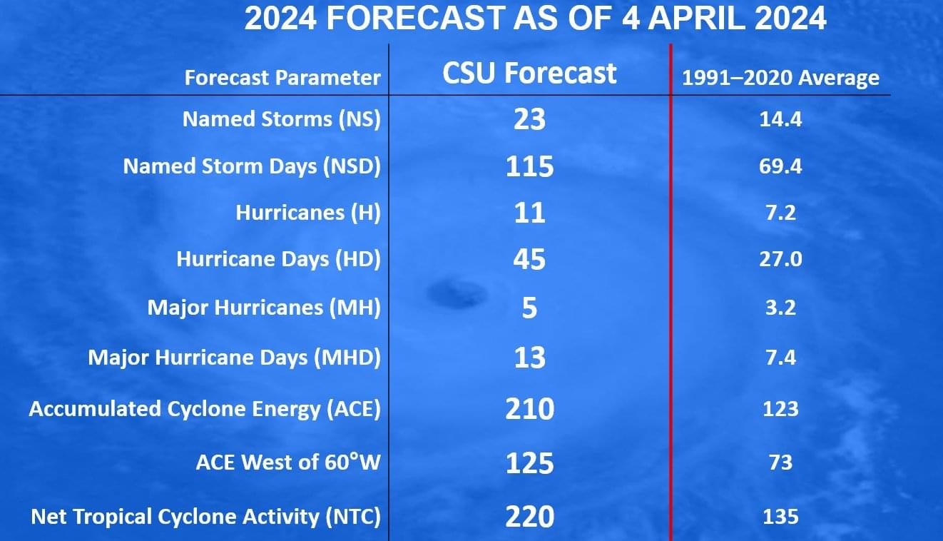
– THE NUMBERS: 25 Named Storms, 12 of those storms becoming Hurricanes and 6 of those hurricanes becoming Major Hurricanes (Category 3 or higher on the Saffir-Simpson scale).

– ACCUMULATED CYCLONE ENERGY (ACE) INDEX FORECAST: I am forecasting an ACE index this year of 225, which not only signals that this will be a hyperactive season, but also would put this upcoming hurricane season in the top ten of the most active hurricane seasons on record.

– ENSO CONDITIONS: The current El Nino conditions are rapidly weakening with cooler than average waters now showing up in the eastern Pacific. It seems quite likely that the ENSO conditions will become ENSO neutral sometime during April and then become La Nina conditions during about the July and August time period.

This reversal in ENSO conditions means that it will most definitely enhance tropical storm and hurricane activity across the Atlantic Basin this season with well above average amounts of activity in terms of the number of tropical storms and hurricanes.

– SEA SURFACE TEMPERATURES: Once again, the lack of any real winter this year has significantly affected the ocean water temperatures across the North Atlantic and the Gulf of Mexico with well above average temperatures almost everywhere.

Of particular note is the eastern Tropical Atlantic where both ocean water temperatures and ocean heat content are in record warmth territory. In fact, the ocean temperatures over the eastern Tropical Atlantic are as high as what you would normally expect them to be during mid-June.

One of the keys in determining how active/inactive the hurricane season will be is how much will the deep tropics (south of 25 North Latitude) warms up during April, May and June. The latest climate models suggests that well above average ocean water temperatures will remain locked across the deep tropics leading to the potential for a very active season in the deep tropics with “classic” long track Cape Verde storms very much on the table.

– ANALOG YEARS: These are the analog years that seem to be a close match right now to what the 2024 hurricane season may be like. They are 1878, 1889, 1896, 1915, 1958, 1966, 1995, 1998, 2005, 2010, 2016 & 2020.

– LANDFALL THREAT FORECAST: There are two areas that I’m most concerned about for this upcoming season in terms of a tropical storm or hurricane impact.

The First Area Is the Caribbean and in particular the northeastern Caribbean and the northwestern Caribbean. The extremely warm ocean temperatures over the deep tropical eastern Atlantic combined with the developing La Nina conditions and a upper level weather pattern that features a big Bermuda high pressure system to the north means long-track tropical storms and hurricanes will be a big, big threat.

I think the islands of the northeastern Caribbean, including the northern Leeward Islands, the Virgin Islands and Puerto Rico could be at significant risk this season. I also think that the islands of the northwestern Caribbean, including the Cayman Islands, the northeastern Yucatan Peninsula and western Cuba could also be at significant risk this season.

The Second Area Of Particular Concern Is a corridor from the Bahamas through the Florida Peninsula to the eastern Gulf of Mexico. As I mentioned previously, I think that the main storm track this season will be further west than last year, which means that many of the storms will be passing through the Bahamas and the Florida Peninsula. The eastern Gulf of Mexico may be affected in two ways – one by systems moving westward from the Bahamas and two by any systems moving northward from the Caribbean.

Other Areas Of Concern Include the central and northwestern Gulf coast and the southeastern coast of the United States where tropical activity may be drawn northward up the East Coast of the United States from the northern Caribbean islands or pulled northward into the Gulf of Mexico from the Caribbean.

Another area to closely monitor is the central and southern Lesser Antilles and Barbados where Cape Verde storms may impact on their track westward.

Even though your area may have a low or medium risk this season, be aware that any small fluctuations in the upper level weather pattern at the “wrong” time could threaten the low or medium risk areas.

STAY WAY AHEAD of everyone else during this upcoming hurricane season by becoming a Crown Weather PLUS subscriber.

To become a Crown Weather PLUS subscriber today, just go to the following link – https://crownweather.com/index.php/cws-plus/crown-weather-subscription/ .

#weather #Hurricane #HurricaneSeason #txwx #lawx #mswx #alwx #flwx #gawx #scwx #ncwx #Caribbean #Weather #Texas #Louisiana #Mississippi #Alabama #Florida #Georgia #SouthCarolina #NorthCarolina

Hurricane Season Projection

Hurricane Season from Hell First look2 months ago

December 7, 2023

  • A hurricane season from hell is shaping up for 2024.
  • Very high levels of activity should be prepared for in areas that were essentially left untouched in 2023.
  • The El Niño will reverse to a La Niña, while the Atlantic basin will be ideal for development.
  • Very warm water in the northeastern Pacific is likely to mean the kind of pattern over North America that was similar to 2005, 2007, and 2020.
    • This invited storms to reach the U.S.

Basin Forecast

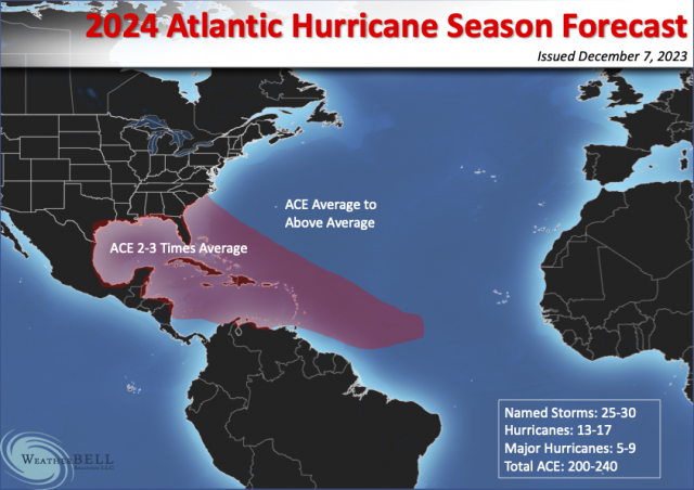
Names Storms 25-30
Hurricanes 14-16
Major Hurricanes 6-8
Total ACE 200-240

Note that this comes out to an average ACE per storm of 8.


Impact Forecast

Named storm Impacts 10-14
Hurricane Impacts 5-8

Major Hurricane Impacts 3-5

The forecast map has no areas receiving below-average tropical cyclone activity. The highest areas are expected to be in a cone of 2-3 times average, aimed at our coast, which includes the Caribbean and Bahamas.

Further details will be on the Seasonal Forecasts next year, but I wanted to get this out early to you.

It appears the climate hypothesis that this El Niño could reverse quickly is quite possible.

Potential Tropical Cyclone. Advisory # 3A

BULLETIN
Potential Tropical Cyclone Twenty-Two
Intermediate Advisory Number 3A
NWS National Hurricane Center Miami FL       AL222023
700 AM EST Fri Nov 17 2023

...HEAVY RAINS CONTINUE TO DOUSE PORTIONS OF JAMAICA, EASTERN CUBA, 
AND HAITI...


SUMMARY OF 700 AM EST...1200 UTC...INFORMATION
----------------------------------------------
LOCATION...16.8N 79.6W
ABOUT 200 MI...325 KM WSW OF KINGSTON JAMAICA
MAXIMUM SUSTAINED WINDS...35 MPH...55 KM/H
PRESENT MOVEMENT...NE OR 40 DEGREES AT 10 MPH...17 KM/H
MINIMUM CENTRAL PRESSURE...1004 MB...29.65 INCHES


WATCHES AND WARNINGS
--------------------
CHANGES WITH THIS ADVISORY:

None.

SUMMARY OF WATCHES AND WARNINGS IN EFFECT:

A Tropical Storm Watch is in effect for...
* Jamaica
* Haiti
* Cuban provinces of Guantanamo, Santiago de Cuba, Holguin, Granma,
and Las Tunas
* Southeastern Bahamas and Turks and Caicos Islands

A Tropical Storm Watch means that tropical storm conditions are
possible within the watch area, generally within 48 hours.

For storm information specific to your area, please monitor
products issued by your national meteorological service.


DISCUSSION AND OUTLOOK
----------------------
At 700 AM EST (1200 UTC), the disturbance was centered near latitude
16.8 North, longitude 79.6 West.  The system is moving toward the
northeast near 10 mph (17 km/h), and this motion is expected to
continue with increasing forward speed through the weekend.  On the
forecast track, the center of the system is expected to move across
Jamaica later today, southeastern Cuba by early Saturday, and the
southeastern Bahamas and Turks and Caicos Islands on Saturday.

Maximum sustained winds are near 35 mph (55 km/h) with higher
gusts. Some strengthening is possible during the next couple of
days, and the disturbance could become a tropical storm later today
or tonight.
* Formation chance through 48 hours...medium...50 percent.
* Formation chance through 7 days...medium...50 percent.  

The estimated minimum central pressure is 1004 mb (29.65 inches).


HAZARDS AFFECTING LAND
----------------------
Key messages for Potential Tropical Cyclone Twenty-Two can be found
in the Tropical Cyclone Discussion under AWIPS header MIATCDAT2 and
WMO header WTNT42 KNHC, and on the web at
hurricanes.gov/text/MIATCDAT2.shtml

WIND:  Tropical storm conditions are possible on Jamaica beginning
later today, eastern Cuba and Haiti tonight, and the southeastern
Bahamas and Turks and Caicos Islands on Saturday.

RAINFALL:  Potential Tropical Cyclone Twenty-Two is expected to
produce storm total rainfall of 5 to 10 inches with maximum amounts
of 16 inches across portions of Panama, Costa Rica, Jamaica,
southeast Cuba, and Hispaniola through Sunday morning. These rains
are likely to produce flash flooding, along with mudslides in areas
of higher terrain.

2 to 4 inches of rain are expected across the southeastern Bahamas
and Turks and Caicos Islands through Sunday morning.

STORM SURGE:  Minor coastal flooding is possible in areas of
onshore winds along the southeastern coast of Cuba, the southeastern
Bahamas, and the Turks and Caicos Islands.

SURF:  Swells generated by the disturbance are expected to affect
portions of Jamaica, Haiti, and southeastern Cuba during the next
couple of days.  These swells are likely to cause life-threatening
surf and rip current conditions.  Please consult products from your
local weather office.

Potential Tropical Cyclone. Advisory # 2

BULLETIN
Potential Tropical Cyclone Twenty-Two Advisory Number   2
NWS National Hurricane Center Miami FL       AL222023
1000 PM EST Thu Nov 16 2023

...AREAS OF HEAVY RAINS SPREADING ACROSS PORTIONS OF JAMAICA,
EASTERN CUBA, AND HAITI...


SUMMARY OF 1000 PM EST...0300 UTC...INFORMATION
-----------------------------------------------
LOCATION...15.9N 81.1W
ABOUT 320 MI...515 KM WSW OF KINGSTON JAMAICA
ABOUT 155 MI...245 KM ENE OF CABO GRACIAS A DIOS ON NIC/HON BORDER
MAXIMUM SUSTAINED WINDS...35 MPH...55 KM/H
PRESENT MOVEMENT...NNE OR 15 DEGREES AT 8 MPH...13 KM/H
MINIMUM CENTRAL PRESSURE...1004 MB...29.65 INCHES


WATCHES AND WARNINGS
--------------------
CHANGES WITH THIS ADVISORY:

None

SUMMARY OF WATCHES AND WARNINGS IN EFFECT:

A Tropical Storm Watch is in effect for...
* Jamaica
* Haiti
* Cuban provinces of Guantanamo, Santiago de Cuba, Holguin, Granma,
and Las Tunas
* Southeastern Bahamas and Turks and Caicos Islands

A Tropical Storm Watch means that tropical storm conditions are
possible within the watch area, generally within 48 hours.

For storm information specific to your area, please monitor
products issued by your national meteorological service.


DISCUSSION AND OUTLOOK
----------------------
At 1000 PM EST (0300 UTC), the disturbance was centered near
latitude 15.9 North, longitude 81.1 West. The system is moving
toward the north-northeast near 8 mph (13 km/h). A northeastward 
motion is expected to begin early Friday, with increasing forward 
speed through the weekend.  On the forecast track, the center of 
the system is expected to move across Jamaica on Friday, 
southeastern Cuba by early Saturday, and the southeastern Bahamas 
and Turks and Caicos Islands on Saturday.

Maximum sustained winds are near 35 mph (55 km/h) with higher gusts.
Some strengthening is forecast during the next couple of days, and 
the disturbance is expected to become a tropical storm on Friday.
* Formation chance through 48 hours...high...70 percent.
* Formation chance through 7 days...high...70 percent.

The estimated minimum central pressure is 1004 mb (29.65 inches).


HAZARDS AFFECTING LAND
----------------------
Key messages for Potential Tropical Cyclone Twenty-Two can be found
in the Tropical Cyclone Discussion under AWIPS header MIATCDAT2 and
WMO header WTNT42 KNHC, and on the web at
hurricanes.gov/text/MIATCDAT2.shtml

WIND:  Tropical storm conditions are possible on Jamaica beginning
Friday, eastern Cuba and Haiti Friday night, and the southeastern
Bahamas and Turks and Caicos Islands on Saturday.

RAINFALL:  Potential Tropical Cyclone Twenty-Two is expected to 
produce storm total rainfall of 5 to 10 inches with maximum amounts 
of 16 inches across portions of Panama, Costa Rica, Jamaica, 
southeast Cuba, and Hispaniola through Sunday morning. These rains 
are likely to produce flash flooding, along with mudslides in areas 
of higher terrain.

Rainfall amounts of 2 to 4 inches are expected across the 
southeastern Bahamas and Turks and Caicos Islands through Sunday 
morning.

STORM SURGE:  Minor coastal flooding is possible in areas of
onshore winds along the southeastern coast of Cuba, the southeastern
Bahamas, and the Turks and Caicos Islands.

SURF:  Swells generated by the disturbance are expected to affect
portions of Jamaica, Haiti, and southeastern Cuba during the next
couple of days.  These swells are likely to cause life-threatening
surf and rip current conditions.  Please consult products from your
local weather office.

Potential Tropical Cyclone. Advisory #1

TCPAT2

BULLETIN
Potential Tropical Cyclone Twenty-Two Advisory Number   1
NWS National Hurricane Center Miami FL       AL222023
400 PM EST Thu Nov 16 2023

...DISTURBANCE OVER THE WEST-CENTRAL CARIBBEAN SEA FORECAST TO
BECOME A TROPICAL STORM...
...TROPICAL STORM WATCHES ISSUED FOR PORTIONS OF THE GREATER
ANTILLES, SOUTHEASTERN BAHAMAS, AND TURKS AND CAICOS ISLANDS...


SUMMARY OF 400 PM EST...2100 UTC...INFORMATION
----------------------------------------------
LOCATION...15.2N 81.5W
ABOUT 365 MI...590 KM WSW OF KINGSTON JAMAICA
ABOUT 115 MI...185 KM E OF CABO GRACIAS A DIOS ON NIC/HON BORDER
MAXIMUM SUSTAINED WINDS...35 MPH...55 KM/H
PRESENT MOVEMENT...NNE OR 15 DEGREES AT 9 MPH...15 KM/H
MINIMUM CENTRAL PRESSURE...1004 MB...29.65 INCHES


WATCHES AND WARNINGS
--------------------
CHANGES WITH THIS ADVISORY:

The government of Jamaica has issued a Tropical Storm Watch for
Jamaica.

A Tropical Storm Watch has been issued for all of Haiti.

The government of Cuba has issued a Tropical Storm Watch for the
provinces of Guantanamo, Santiago de Cuba, Holguin, Granma, and Las
Tunas.

The government of the Bahamas has issued a Tropical Storm Watch for
the southeastern Bahamas and the Turks and Caicos Islands.

SUMMARY OF WATCHES AND WARNINGS IN EFFECT:

A Tropical Storm Watch is in effect for...
* Jamaica
* Haiti
* Cuban provinces of Guantanamo, Santiago de Cuba, Holguin, Granma,
and Las Tunas
* Southeastern Bahamas and Turks and Caicos Islands

A Tropical Storm Watch means that tropical storm conditions are
possible within the watch area, generally within 48 hours.

For storm information specific to your area, please monitor
products issued by your national meteorological service.


DISCUSSION AND OUTLOOK
----------------------
At 400 PM EST (2100 UTC), the disturbance was centered near latitude
15.2 North, longitude 81.5 West. The system is moving toward the
north-northeast near 9 mph (15 km/h).  A northeastward motion is
expected to begin tonight, with an increase in forward speed into
the weekend.  On the forecast track, the center of the system is
expected to move across Jamaica late Friday, southeastern Cuba
early Saturday, and the southeastern Bahamas and Turks and Caicos
Islands on Saturday.

Maximum sustained winds are near 35 mph (55 km/h) with higher gusts.
Strengthening is forecast during the next few days, and the
disturbance is expected to become a tropical storm on Friday.
* Formation chance through 48 hours...high...70 percent.
* Formation chance through 7 days...high...70 percent.

The estimated minimum central pressure is 1004 mb (29.65 inches).


HAZARDS AFFECTING LAND
----------------------
Key messages for Potential Tropical Cyclone Twenty-Two can be found
in the Tropical Cyclone Discussion under AWIPS header MIATCDAT2 and
WMO header WTNT42 KNHC, and on the web at
hurricanes.gov/text/MIATCDAT2.shtml

WIND:  Tropical storm conditions are possible on Jamaica beginning
Friday, eastern Cuba and Haiti Friday night, and the southeastern 
Bahamas and Turks and Caicos Islands on Saturday.

RAINFALL:  Potential Tropical Cyclone Twenty-Two is expected to
produce storm total rainfall of 5 to 10 inches with maximum amounts
of 16 inches across portions of Panama, Costa Rica, Jamaica,
southeastern Cuba, and Hispaniola through Monday morning. These
rains are likely to produce flash flooding, along with mudslides in
areas of higher terrain.

STORM SURGE:  Minor coastal flooding is possible in areas of
onshore winds along the southeastern coast of Cuba, the southeastern
Bahamas, and the Turks and Caicos Islands.

SURF:  Swells generated by the disturbance are expected to affect
portions of Jamaica, Haiti, and southeastern Cuba during the next
couple of days.  These swells are likely to cause life-threatening
surf and rip current conditions.  Please consult products from your
local weather office.

6-1 – 2pm Tropical Update

Tropical Weather Outlook
NWS National Hurricane Center Miami FL
200 PM EDT Wed Jun 1 2022

For the North Atlantic...Caribbean Sea and the Gulf of Mexico:

1. Near the Yucatan Peninsula and Southeastern Gulf of Mexico: 
A broad area of low pressure located near the east coast of the 
Yucatan Peninsula is producing a large area of disorganized 
showers and thunderstorms over the northwestern Caribbean Sea
and Yucatan Peninsula.  Despite strong upper-level winds, gradual 
development is forecast and this system is likely to become a 
tropical depression while it moves slowly northeastward over the 
northwestern Caribbean Sea and southeastern Gulf of Mexico during 
the next day or two.  Regardless of development, locally heavy 
rainfall is likely across portions of the Yucatan Peninsula during 
the next day or so, spreading across western Cuba, South Florida, 
and the Florida Keys on Friday and Saturday. Interests in the 
Yucatan Peninsula, western Cuba, the Florida Keys, and the Florida 
Peninsula should monitor the progress of this system.
* Formation chance through 48 hours...high...70 percent.
* Formation chance through 5 days...high...80 percent.

2. Southwestern Atlantic northeast of the Bahamas:
A weak surface trough located about 150 miles northeast of the 
northwest Bahamas is producing disorganized shower activity. 
Surface pressures are currently high across the area, and 
significant development of this system appears unlikely as it moves generally east-northeastward over the next several days away from 
the southeastern United States.
* Formation chance through 48 hours...low...10 percent.
* Formation chance through 5 days...low...10 percent.2pm Update

The Hurricane Season Starts

WED 6/1/2022 – 9AM CST

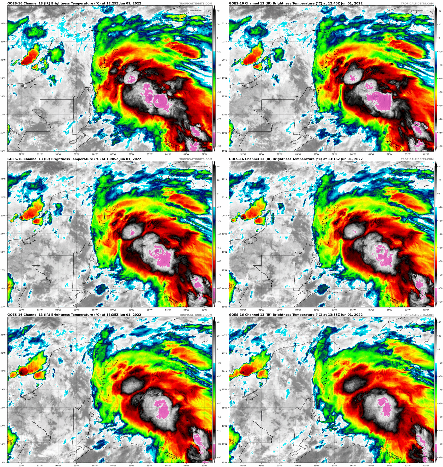
Today marks the first official day of the 2022 Atlantic Hurricane Season and we are watching newly designated Invest 91 near the Yucatan Peninsula for development. It has an 80% chance of developing as it track towards Florida this week. We do not expect anything stronger than a minimal tropical storm. The first name would be Alex. Heavy rain and isolated flash flooding will be the main concerns with this system. Stay tuned for updates.


Tropical Update 3/31

Tropical Weather Outlook
NWS National Hurricane Center Miami FL
200 PM EDT Tue May 31 2022

For the North Atlantic...Caribbean Sea and the Gulf of Mexico:

Near the Yucatan Peninsula and Southeastern Gulf of Mexico: 
A large and complex area of low pressure is expected to develop near the Yucatan Peninsula and the northwestern Caribbean Sea in a couple of days, partially related to the remnants of Agatha from the eastern Pacific.  Despite strong upper-level winds over the area, this system is likely to become a tropical depression while it moves northeastward over the northwestern Caribbean Sea and 
southeastern Gulf of Mexico late Thursday or Friday.  

Regardless of development, locally heavy rainfall is likely across portions of southeastern Mexico, the Yucatan Peninsula, Guatemala, and Belize during the next couple of days, spreading across western Cuba, southern Florida, and the Florida Keys on Friday and Saturday.  

Interests in the Yucatan Peninsula, western Cuba, the Florida Keys 
and the Florida Peninsula should monitor the progress of this 
system.
* Formation chance through 48 hours...low...30 percent.
* Formation chance through 5 days...high...70 percent.

$$