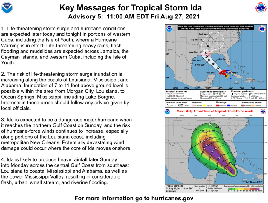
BULLETIN
Hurricane Ida Intermediate Advisory Number 5A
NWS National Hurricane Center Miami FL       AL092021
200 PM EDT Fri Aug 27 2021

...IDA MAKES LANDFALL AS A HURRICANE ON THE ISLE OF YOUTH...


SUMMARY OF 200 PM EDT...1800 UTC...INFORMATION
----------------------------------------------
LOCATION...21.6N 82.7W
ABOUT 5 MI...10 KM E OF THE CENTER OF THE ISLE OF YOUTH
ABOUT 145 MI...245 KM E OF THE WESTERN TIP OF CUBA
MAXIMUM SUSTAINED WINDS...75 MPH...120 KM/H
PRESENT MOVEMENT...NW OR 325 DEGREES AT 15 MPH...24 KM/H
MINIMUM CENTRAL PRESSURE...987 MB...29.15 INCHES


WATCHES AND WARNINGS
--------------------
CHANGES WITH THIS ADVISORY:

The government of the Cayman Islands has discontinued all Tropical
Storm Warnings.

SUMMARY OF WATCHES AND WARNINGS IN EFFECT:

A Hurricane Warning is in effect for...
* Cuban provinces of Pinar del Rio and Artemisa, and the Isle of
Youth

A Storm Surge Watch is in effect for...
* Sabine Pass to Alabama/Florida border
* Vermilion Bay, Lake Borgne, Lake Pontchartrain, Lake Maurepas, and
Mobile Bay

A Hurricane Watch is in effect for...
* Cameron, Louisiana to the Mississippi/Alabama border
* Lake Pontchartrain, Lake Maurepas, and Metropolitan New Orleans

A Tropical Storm Warning is in effect for...
* Cuban provinces of Matanzas, Mayabeque, and Havana

A Tropical Storm Watch is in effect for...
* Mississippi/Alabama border to the Alabama/Florida border.

A Hurricane Warning means that hurricane conditions are expected
somewhere within the warning area.

A Tropical Storm Warning means that tropical storm conditions are
expected somewhere within the warning area.

A Storm Surge Watch means there is a possibility of life-
threatening inundation, from rising water moving inland from the
coastline, in the indicated locations during the next 48 hours.
For a depiction of areas at risk, please see the National Weather
Service Storm Surge Watch/Warning Graphic, available at
hurricanes.gov.

A Hurricane Watch means that hurricane conditions are possible
within the watch area.  A watch is typically issued 48 hours
before the anticipated first occurrence of tropical-storm-force
winds, conditions that make outside preparations difficult or
dangerous.

A Tropical Storm Watch means that tropical storm conditions are
possible within the watch area, generally within 48 hours.

Interests elsewhere in central and western Cuba and elsewhere along
the northern U.S. Gulf coast should monitor the progress of this
system.  Hurricane warnings will likely be required for portions of
the northern Gulf coast later today.  Interests in the Dry Tortugas
should also monitor the progress of Ida.

For storm information specific to your area in the United
States, including possible inland watches and warnings, please
monitor products issued by your local National Weather Service
forecast office. For storm information specific to your area
outside of the United States, please monitor products issued by
your national meteorological service.


DISCUSSION AND OUTLOOK
----------------------
At 200 PM EDT (1800 UTC), the center of Hurricane Ida was located
by Cuban radar and Air Force Reserve Hurricane Hunter aircraft near
latitude 21.6 North, longitude 82.7 West. Ida is moving toward the
northwest near 15 mph (24 km/h), and this general motion should
continue over the next few days.  On the forecast track, the
center of Ida will pass over the Isle of Youth during the next
hour or so, move over western Cuba later today, and move over the
southeastern and central Gulf of Mexico tonight and Saturday. Ida
is forecast to make landfall along the U.S. northern Gulf coast
within the hurricane watch area on Sunday.

Reports from Air Force Reserve reconnaissance aircraft indicate
that the maximum sustained winds are near 75 mph (120 km/h) with
higher gusts.  Additional strengthening is forecast before the
center moves over western Cuba later today.  Steady to rapid
strengthening is expected when Ida moves over the southeastern and
central Gulf of Mexico over the weekend, and Ida is expected to be
a major hurricane when it approaches the northern Gulf coast.

Hurricane-force winds extend outward up to 20 miles (30 km) from the
center.  Tropical-storm-force winds extend outward up to 90 miles
(150 km) from the center. Sustained winds of 38 mph (61 km/h) and a
gust to 55 mph (89 km/h) has recently been observed on Cayo Largo,
Cuba.

The latest minimum central pressure estimated from Air Force
Reserve reconnaissance aircraft data is 987 mb (29.15 inches).


HAZARDS AFFECTING LAND
----------------------
Key messages for Ida can be found in the Tropical Cyclone
Discussion under AWIPS header MIATCDAT4, WMO header WTNT44 KNHC,
and on the web at hurricanes.gov/graphics_at4.shtml?key_messages.

STORM SURGE:  A dangerous storm surge will raise water levels by
as much as 4 to 6 feet above normal tide levels in areas of onshore
winds along the immediate coast of the Isle of Youth and near and to
the east of where the center crosses the coast of western Cuba.
Near the coast, the surge will be accompanied by large and
destructive waves.

The combination of a dangerous storm surge and the tide will cause
normally dry areas near the coast to be flooded by rising waters
moving inland from the shoreline.  The water could reach the
following heights above ground somewhere in the indicated areas if
the peak surge occurs at the time of high tide...

Morgan City, LA to Ocean Springs, MS including Lake Borgne...7-11 ft
Rockefeller Wildlife Refuge, LA to Morgan City, LA including
Vermilion Bay...4-7 ft
Ocean Springs, MS to MS/AL border...4-7 ft
MS/AL border to AL/FL border including Mobile Bay...3-5 ft
Lake Pontchartrain...4-6 ft
Lake Maurepas...3-5 ft
Sabine Pass to Rockefeller Wildlife Refuge, LA...2-4 ft

Overtopping of local levees outside of the Hurricane and Storm
Damage Risk Reduction System is possible where local inundation
values may be higher than those shown above.

The deepest water will occur along the immediate coast near and to
the east of the landfall location, where the surge will be
accompanied by large and dangerous waves.  Surge-related flooding
depends on the relative timing of the surge and the tidal cycle,
and can vary greatly over short distances.  For information
specific to your area, please see products issued by your local
National Weather Service forecast office.

WIND:  Hurricane conditions are occuring over the Isle of Youth
and are expected to spread over portions of western Cuba in the
hurricane warning area by later this afternoon and evening.
Tropical storm conditions are already beginning to reach portions
of western Cuba and will continue through early Saturday.

Hurricane conditions are possible in the hurricane watch area along
the northern Gulf coast late Saturday night or Sunday and tropical
storm conditions are possible in the watch area late Saturday night
or Sunday.

RAINFALL:  Ida is expected to produce total rainfall accumulations
of 6 to 10 inches with maximum totals of 15 inches across Jamaica.
Rainfall totals of 8 to 12 inches with isolated maximum amounts of
20 inches are expected across the Cayman Islands and western Cuba,
including the Isle of Youth.  These rainfall amounts may produce
life-threatening flash floods and mudslides.

As Ida approaches the central Gulf Coast Sunday afternoon, total
rainfall accumulations of 8 to 16 inches with isolated maximum
amounts of 20 inches are possible from southeast Louisiana to
coastal Mississippi and Alabama through Monday morning. Ida is
forecast to turn northeast as it moves inland later Monday with
rainfall totals of 4 to 8 inches possible across southern and
central Mississippi. This is likely to result in considerable flash,
urban, small stream, and riverine flooding.

SURF:  Swells generated by this system will affect the Cayman
Islands and Cuba through tonight. Swells will begin reaching
portions of the northern Gulf coast Saturday night or early Sunday.
These swells are likely to cause life-threatening surf and rip
current conditions. Please consult products from your local weather
office.
Monthly Archives: August 2021
Ida now Cat. 1 Hurricane
Hurricane Ida Tropical Cyclone Update
NWS National Hurricane Center Miami FL       AL092021
115 PM EDT Fri Aug 27 2021

...IDA STRENGTHENS INTO A HURRICANE AS IT NEARS THE ISLE OF YOUTH...

Data from an Air Force Reserve hurricane hunter aircraft indicate
that Ida has strengthened into a hurricane as it approaches the
Isle of Youth, Cuba. The maximum sustained winds are estimated to
be 75 mph (120 km/h) with higher gusts.

A sustained wind of 44 mph (70 km/h) and a gust of 60 mph (96 km/h)
were recently reported on Cayo Largo, Cuba.


SUMMARY OF 110 PM EDT...1710 UTC...INFORMATION
----------------------------------------------
LOCATION...21.4N 82.4W
ABOUT 30 MI...50 KM ESE OF THE ISLE OF YOUTH
ABOUT 165 MI...270 KM E OF THE WESTERN TIP OF CUBA
MAXIMUM SUSTAINED WINDS...75 MPH...120 KM/H
PRESENT MOVEMENT...NW OR 320 DEGREES AT 15 MPH...24 KM/H
MINIMUM CENTRAL PRESSURE...987 MB...29.15 INCHES
TS Ida Advisory # 5
BULLETIN
Tropical Storm Ida Advisory Number   5
NWS National Hurricane Center Miami FL       AL092021
1100 AM EDT Fri Aug 27 2021

...IDA CONTINUES TO STRENGTHEN...
...HURRICANE WARNING ISSUED FOR THE ISLE OF YOUTH AND WESTERN
CUBA...


SUMMARY OF 1100 AM EDT...1500 UTC...INFORMATION
-----------------------------------------------
LOCATION...20.7N 82.1W
ABOUT 75 MI...125 KM SE OF THE ISLE OF YOUTH
ABOUT 200 MI...320 KM ESE OF THE WESTERN TIP OF CUBA
MAXIMUM SUSTAINED WINDS...65 MPH...100 KM/H
PRESENT MOVEMENT...NW OR 320 DEGREES AT 15 MPH...24 KM/H
MINIMUM CENTRAL PRESSURE...996 MB...29.42 INCHES


WATCHES AND WARNINGS
--------------------
CHANGES WITH THIS ADVISORY:

The government of Cuba has replace the Tropical Storm Warning with
a Hurricane Warning for the Isle of Youth, and the Cuban provinces
of Pinar del Rio and Artemisa.

SUMMARY OF WATCHES AND WARNINGS IN EFFECT:

A Hurricane Warning is in effect for...
* Cuban provinces of Pinar del Rio and Artemisa, and the Isle of
Youth

A Storm Surge Watch is in effect for...
* Sabine Pass to Alabama/Florida border
* Vermilion Bay, Lake Borgne, Lake Pontchartrain, Lake Maurepas, and
Mobile Bay

A Hurricane Watch is in effect for...
* Cameron, Louisiana to the Mississippi/Alabama border
* Lake Pontchartrain, Lake Maurepas, and Metropolitan New Orleans

A Tropical Storm Warning is in effect for...
* Little Cayman and Cayman Brac
* Cuban provinces of Matanzas, Mayabeque, and Havana

A Tropical Storm Watch is in effect for...
* Mississippi/Alabama border to the Alabama/Florida border.

A Hurricane Warning means that hurricane conditions are expected
somewhere within the warning area, in this case within the next 12
hours.

A Tropical Storm Warning means that tropical storm conditions are
expected somewhere within the warning area.

A Storm Surge Watch means there is a possibility of life-
threatening inundation, from rising water moving inland from the
coastline, in the indicated locations during the next 48 hours.
For a depiction of areas at risk, please see the National Weather
Service Storm Surge Watch/Warning Graphic, available at
hurricanes.gov.

A Hurricane Watch means that hurricane conditions are possible
within the watch area.  A watch is typically issued 48 hours
before the anticipated first occurrence of tropical-storm-force
winds, conditions that make outside preparations difficult or
dangerous.

A Tropical Storm Watch means that tropical storm conditions are
possible within the watch area, generally within 48 hours.

Interests elsewhere in central and western Cuba and elsewhere along
the northern U.S. Gulf coast should monitor the progress of this
system.  Hurricane warnings will likely be required for portions of
the northern Gulf coast later today.  Interests in the Dry Tortugas
should also monitor the progress of Ida.

For storm information specific to your area in the United States,
including possible inland watches and warnings, please monitor
products issued by your local National Weather Service forecast
office. For storm information specific to your area outside of the
United States, please monitor products issued by your national
meteorological service.


DISCUSSION AND OUTLOOK
----------------------
At 1100 AM EDT (1500 UTC), the center of Tropical Storm Ida was
located near latitude 20.7 North, longitude 82.1 West. Ida is moving
toward the northwest near 15 mph (24 km/h), and this general motion
should continue over the next few days.  On the forecast track, the
center of Ida will pass near or over the Isle of Youth and western
Cuba later today, and move over the southeastern and central Gulf
of Mexico tonight and Saturday. Ida is forecast to make landfall
along the U.S. northern Gulf coast within the hurricane watch area
on Sunday.

Reports from Air Force and NOAA reconnaissance aircraft indicate
that the maximum sustained winds have increased to near 65 mph
(100 km/h) with higher gusts.  Additional strengthening is forecast
today and Ida is expected to be a hurricane when it nears western
Cuba later today.  Steady to rapid strengthening is expected when
Ida moves over the southeastern and central Gulf of Mexico over the
weekend, and Ida is expected to be a major hurricane when it
approaches the northern Gulf coast.

Tropical-storm-force winds extend outward up to 90 miles (150 km)
from the center.  A wind gust to 45 mph (72 km/h) was recently
reported on Cayman Brac and a wind gust to 41 mph (67 km/h) has
been observed on Cayo Largo, Cuba, within the past hour or two.

The latest minimum central pressure reported by an Air Force
Reserve reconnaissance aircraft is 996 mb (29.42 inches).


HAZARDS AFFECTING LAND
----------------------
Key messages for Ida can be found in the Tropical Cyclone
Discussion under AWIPS header MIATCDAT4, WMO header WTNT44 KNHC,
and on the web at hurricanes.gov/graphics_at4.shtml?key_messages.

STORM SURGE:  A dangerous storm surge will raise water levels by
as much as 4 to 6 feet above normal tide levels in areas of onshore
winds along the immediate coast of the Isle of Youth and near and to
the east of where the center crosses the coast of western Cuba.
Near the coast, the surge will be accompanied by large and
destructive waves.

The combination of a dangerous storm surge and the tide will cause
normally dry areas near the coast to be flooded by rising waters
moving inland from the shoreline.  The water could reach the
following heights above ground somewhere in the indicated areas if
the peak surge occurs at the time of high tide...

Morgan City, LA to Ocean Springs, MS including Lake Borgne...7-11 ft
Rockefeller Wildlife Refuge, LA to Morgan City, LA including
Vermilion Bay...4-7 ft
Ocean Springs, MS to MS/AL border...4-7 ft
MS/AL border to AL/FL border including Mobile Bay...3-5 ft
Lake Pontchartrain...4-6 ft
Lake Maurepas...3-5 ft
Sabine Pass to Rockefeller Wildlife Refuge, LA...2-4 ft

Overtopping of local levees outside of the Hurricane and Storm
Damage Risk Reduction System is possible where local inundation
values may be higher than those shown above.

The deepest water will occur along the immediate coast near and to
the east of the landfall location, where the surge will be
accompanied by large and dangerous waves.  Surge-related flooding
depends on the relative timing of the surge and the tidal cycle,
and can vary greatly over short distances.  For information
specific to your area, please see products issued by your local
National Weather Service forecast office.

WIND:  Tropical storm conditions are expected on Little Cayman
and Cayman Brac through early this afternoon. Hurricane conditions
are expected to reach the Isle of Youth and portions of western Cuba
in the Hurricane Warning area by later this afternoon and evening,
with tropical storm conditions beginning within the next couple of
hours on the Isle of Youth.

Hurricane conditions are possible in the hurricane watch area along
the northern Gulf coast late Saturday night or Sunday and tropical
storm conditions are possible in the watch area late Saturday night
or Sunday.

RAINFALL:  Ida is expected to produce total rainfall accumulations
of 6 to 10 inches with maximum totals of 15 inches across Jamaica.
Rainfall totals of 8 to 12 inches with isolated maximum amounts of
20 inches are expected across the Cayman Islands and western Cuba,
including the Isle of Youth.  These rainfall amounts may produce
life-threatening flash floods and mudslides.

As Ida approaches the central Gulf Coast Sunday afternoon, total
rainfall accumulations of 8 to 16 inches with isolated maximum
amounts of 20 inches are possible from southeast Louisiana to
coastal Mississippi and Alabama through Monday morning. Ida is
forecast to turn northeast as it moves inland later Monday with
rainfall totals of 4 to 8 inches possible across southern and
central Mississippi. This is likely to result in considerable flash,
urban, small stream, and riverine flooding.

SURF:  Swells generated by this system will affect the Cayman
Islands and Cuba through tonight. Swells will begin reaching
portions of the northern Gulf coast Saturday night or early Sunday.
These swells are likely to cause life-threatening surf and rip
current conditions. Please consult products from your local weather
office.
TS Ida Advisory # 4A
BULLETIN
Tropical Storm Ida Intermediate Advisory Number 4A
NWS National Hurricane Center Miami FL       AL092021
800 AM EDT Fri Aug 27 2021

...AIR FORCE AND NOAA AIRCRAFT FIND IDA STRENGTHENING OVER THE
NORTHWEST CARIBBEAN SEA...


SUMMARY OF 800 AM EDT...1200 UTC...INFORMATION
----------------------------------------------
LOCATION...20.3N 81.7W
ABOUT 75 MI...125 KM NNW OF GRAND CAYMAN
ABOUT 115 MI...185 KM SE OF THE ISLE OF YOUTH
MAXIMUM SUSTAINED WINDS...60 MPH...95 KM/H
PRESENT MOVEMENT...NW OR 320 DEGREES AT 15 MPH...24 KM/H
MINIMUM CENTRAL PRESSURE...996 MB...29.41 INCHES


WATCHES AND WARNINGS
--------------------
CHANGES WITH THIS ADVISORY:

The government of the Cayman Islands has discontinued the Tropical
Storm Warning for Grand Cayman.  The Tropical Storm Warning remains
in effect for Little Cayman and Cayman Brac.

SUMMARY OF WATCHES AND WARNINGS IN EFFECT:

A Storm Surge Watch is in effect for...
* Sabine Pass to Alabama/Florida border
* Vermilion Bay, Lake Borgne, Lake Pontchartrain, Lake Maurepas, and
Mobile Bay

A Hurricane Watch is in effect for...
* Cameron, Louisiana to the Mississippi/Alabama border
* Lake Pontchartrain, Lake Maurepas, and Metropolitan New Orleans

A Tropical Storm Warning is in effect for...
* Little Cayman and Cayman Brac
* Cuban provinces of Matanzas, Mayabeque, Havana, Artemisa, Pinar
del Rio, and the Isle of Youth

A Tropical Storm Watch is in effect for...
* Mississippi/Alabama border to the Alabama/Florida border.

A Storm Surge Watch means there is a possibility of life-
threatening inundation, from rising water moving inland from the
coastline, in the indicated locations during the next 48 hours.
For a depiction of areas at risk, please see the National Weather
Service Storm Surge Watch/Warning Graphic, available at
hurricanes.gov.

A Hurricane Watch means that hurricane conditions are possible
within the watch area.  A watch is typically issued 48 hours
before the anticipated first occurrence of tropical-storm-force
winds, conditions that make outside preparations difficult or
dangerous.

A Tropical Storm Warning means that tropical storm conditions are
expected somewhere within the warning area within 36 hours.

A Tropical Storm Watch means that tropical storm conditions are
possible within the watch area, generally within 48 hours.

Interests elsewhere in central and western Cuba and elsewhere along
the northern U.S. Gulf coast should monitor the progress of this
system.  Hurricane warnings will likely be required for portions of
the northern Gulf coast later today.  Interests in the Dry Tortugas
should also monitor the progress of Ida.

For storm information specific to your area in the United States,
including possible inland watches and warnings, please monitor
products issued by your local National Weather Service forecast
office. For storm information specific to your area outside of the
United States, please monitor products issued by your national
meteorological service.


DISCUSSION AND OUTLOOK
----------------------
At 800 AM EDT (1200 UTC), the center of Tropical Storm Ida was
located by reconnaissance aircraft and weather radar on Grand
Cayman near latitude 20.3 North, longitude 81.7 West. Ida is moving
toward the northwest near 15 mph (24 km/h) and this general motion
should continue over the next few days.  On the forecast track, the
center of Ida will move away from the Cayman Islands this morning,
pass near or over the Isle of Youth and western Cuba later today,
and move over the southeastern and central Gulf of Mexico tonight
and Saturday. The system is forecast to approach the U.S. northern
Gulf coast on Sunday.

Data from Air Force Reserve and NOAA reconnaissance aircraft
indicate that the maximum sustained winds have increased to near 60
mph (95 km/h) with higher gusts, and additional steady to rapid
strengthening is expected during the next few days.  Ida is forecast
to become a hurricane over the southeastern Gulf of Mexico, and to
be at or near major hurricane strength when it approaches the
northern Gulf coast.

Tropical-storm-force winds extend outward up to 80 miles (130 km)
from the center.

The estimated minimum central pressure from reconnaissance
aircraft data is 996 mb (29.41 inches).


HAZARDS AFFECTING LAND
----------------------
Key messages for Tropical Storm Ida can be found in the
Tropical Cyclone Discussion under AWIPS header MIATCDAT4, WMO
header WTNT44 KNHC, and on the web at
hurricanes.gov/graphics_at4.shtml?key_messages.

STORM SURGE:  A dangerous storm surge will raise water levels by
as much as 2 to 4 feet above normal tide levels in areas of onshore
winds along the immediate coast of the Isle of Youth and near and to
the east of where the center crosses the coast of western Cuba.
Near the coast, the surge will be accompanied by large and
destructive waves.

The combination of a dangerous storm surge and the tide will cause
normally dry areas near the coast to be flooded by rising waters
moving inland from the shoreline.  The water could reach the
following heights above ground somewhere in the indicated areas if
the peak surge occurs at the time of high tide...

Morgan City, LA to Ocean Springs, MS including Lake Borgne...7-11 ft
Rockefeller Wildlife Refuge, LA to Morgan City, LA including
Vermilion Bay...4-7 ft
Ocean Springs, MS to MS/AL border...4-7 ft
MS/AL border to AL/FL border including Mobile Bay...3-5 ft
Lake Pontchartrain...4-6 ft
Lake Maurepas...3-5 ft
Sabine Pass to Rockefeller Wildlife Refuge, LA...2-4 ft

Overtopping of local levees outside of the Hurricane and Storm
Damage Risk Reduction System is possible where local inundation
values may be higher than those shown above.

The deepest water will occur along the immediate coast near and to
the east of the landfall location, where the surge will be
accompanied by large and dangerous waves.  Surge-related flooding
depends on the relative timing of the surge and the tidal cycle,
and can vary greatly over short distances.  For information
specific to your area, please see products issued by your local
National Weather Service forecast office.

WIND:  Tropical storm conditions are expected on Little Cayman
and Cayman Brac this morning, and are expected to reach the Isle of
Youth and portions of western Cuba in the warning area later today.
Hurricane conditions are possible in the hurricane watch area along
the northern Gulf coast late Saturday night or Sunday and tropical
storm conditions are possible in the watch area late Saturday night
or Sunday.

RAINFALL:  Ida is expected to produce total rainfall accumulations
of 6 to 10 inches with maximum totals of 15 inches across Jamaica.
Rainfall totals of 8 to 12 inches with isolated maximum amounts of
20 inches are expected across the Cayman Islands and western Cuba,
including the Isle of Youth.  These rainfall amounts may produce
life-threatening flash floods and mudslides.

As Ida approaches the central Gulf Coast Sunday afternoon, total
rainfall accumulations of 8 to 16 inches with isolated maximum
amounts of 20 inches are possible from southeast Louisiana to
coastal Mississippi and Alabama through Monday morning. Ida is
forecast to turn northeast as it moves inland later Monday with
rainfall totals of 4 to 8 inches possible across southern and
central Mississippi. This is likely to result in considerable flash,
urban, small stream, and riverine flooding.

SURF:  Swells generated by this system will affect Jamaica, the
Cayman Islands and Cuba tonight and Friday. Swells will begin
reaching portions of the northern Gulf coast Saturday night or
early Sunday.  These swells are likely to cause life-threatening
surf and rip current conditions. Please consult products from your
local weather office.
T.S. Ida has formed.
BULLETIN
Tropical Storm Ida Intermediate Advisory Number 2A
NWS National Hurricane Center Miami FL       AL092021
800 PM EDT Thu Aug 26 2021

...IDA FORECAST TO STRENGTHEN...
...TROPICAL STORM CONDITIONS EXPECTED IN THE CAYMAN ISLANDS
LATER TONIGHT AND ACROSS WESTERN CUBA ON FRIDAY...


SUMMARY OF 800 PM EDT...0000 UTC...INFORMATION
----------------------------------------------
LOCATION...18.0N 80.1W
ABOUT 115 MI...185 KM SE OF GRAND CAYMAN
ABOUT 120 MI...195 KM W OF NEGRIL JAMAICA
MAXIMUM SUSTAINED WINDS...40 MPH...65 KM/H
PRESENT MOVEMENT...NW OR 310 DEGREES AT 13 MPH...20 KM/H
MINIMUM CENTRAL PRESSURE...1006 MB...29.71 INCHES


WATCHES AND WARNINGS
--------------------
CHANGES WITH THIS ADVISORY:

None.

SUMMARY OF WATCHES AND WARNINGS IN EFFECT:

A Tropical Storm Warning is in effect for...
* Cayman Islands
* Cuban provinces of Matanzas, Mayabeque, Havana, Artemisa, Pinar
del Rio, and the Isle of Youth

A Tropical Storm Warning means that tropical storm conditions are
expected somewhere within the warning area within 36 hours.

Interests elsewhere in central and western Cuba, in the northern
Yucatan Peninsula, and along the northern U.S. Gulf coast should
monitor the progress of this system.  Watches may be required for a
portion of the northern Gulf coast later tonight or Friday morning.

For storm information specific to your area, please monitor
products issued by your national meteorological service.


DISCUSSION AND OUTLOOK
----------------------
At 800 PM EDT (0000 UTC), the center of Tropical Storm Ida was
located near latitude 18.0 North, longitude 80.1 West. The storm is
moving toward the northwest near 13 mph (20 km/h), and this general
motion should continue over the next few days.  On the forecast
track, the center of Ida will pass near or over the Cayman Islands
tonight, the Isle of Youth and western Cuba Friday, and over the
southeastern and central Gulf of Mexico Friday night and Saturday.
The system is forecast to approach the U.S. northern Gulf coast on
Sunday.

Maximum sustained winds are near 40 mph (65 km/h) with higher gusts.
Steady strengthening is forecast during the next few days. Ida is
forecast to become a hurricane when it is near western Cuba with
additional strengthening expected while it moves over the Gulf of
Mexico. Ida could be near major hurricane strength when it
approaches the northern Gulf coast.

Tropical-storm-force winds extend outward up to 70 miles (110 km)
north of the center.

The estimated minimum central pressure based on Air Force Reserve
reconnaissance data is 1006 mb (29.71 inches).


HAZARDS AFFECTING LAND
----------------------
Key messages for Tropical Storm Ida can be found in the
Tropical Cyclone Discussion under AWIPS header MIATCDAT4, WMO
header WTNT44 KNHC, and on the web at
hurricanes.gov/graphics_at4.shtml?key_messages.

STORM SURGE:  A dangerous storm surge will raise water levels by
as much as 2 to 4 feet above normal tide levels in areas of onshore
winds along the immediate coast of the Isle of Youth and near and to
the east of where the center crosses the coast of western Cuba.
Near the coast, the surge will be accompanied by large and
destructive waves.

WIND:  Tropical storm conditions are expected in the Cayman Islands
tonight, and are expected to reach the Isle of Youth and portions of
western Cuba in the warning area on Friday.

RAINFALL:  Ida is expected to produce total rainfall accumulations
of 6 to 10 inches with maximum totals of 15 inches across Jamaica.
Rainfall totals of 8 to 12 inches with isolated maximum amounts of
20 inches are expected across the Cayman Islands and western Cuba,
including the Isle of Youth. These rainfall amounts may produce
life-threatening flash floods and mudslides.

Ida may begin to bring rainfall and potential flooding impacts to
the central Gulf Coast by early Sunday.

SURF:  Swells generated by this system will affect Jamaica, the
Cayman Islands and Cuba tonight and Friday. These swells are likely
to cause life-threatening surf and rip current conditions. Please
consult products from your local weather office.
TD 9, Advisory # 2
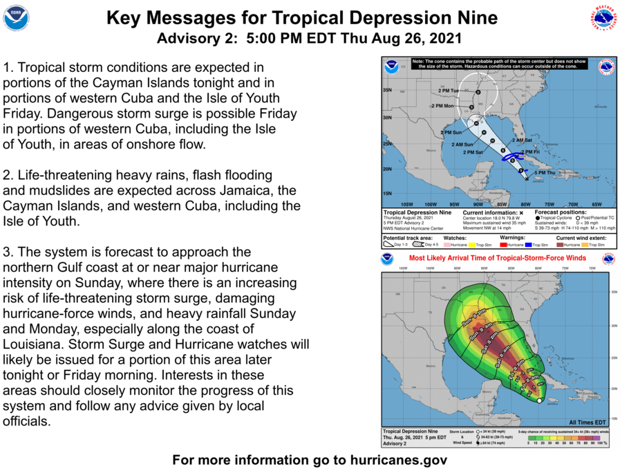
BULLETIN
Tropical Depression Nine Advisory Number   2
NWS National Hurricane Center Miami FL       AL092021
500 PM EDT Thu Aug 26 2021

...DEPRESSION EXPECTED TO STRENGTHEN INTO A TROPICAL STORM SOON...
...AIR FORCE HURRICANE HUNTER AIRCRAFT CURRENTLY INVESTIGATING THE
SYSTEM...


SUMMARY OF 500 PM EDT...2100 UTC...INFORMATION
----------------------------------------------
LOCATION...18.0N 79.8W
ABOUT 100 MI...160 KM WSW OF NEGRIL JAMAICA
ABOUT 130 MI...205 KM SE OF GRAND CAYMAN
MAXIMUM SUSTAINED WINDS...35 MPH...55 KM/H
PRESENT MOVEMENT...NW OR 325 DEGREES AT 14 MPH...22 KM/H
MINIMUM CENTRAL PRESSURE...1006 MB...29.71 INCHES


WATCHES AND WARNINGS
--------------------
CHANGES WITH THIS ADVISORY:

None.

SUMMARY OF WATCHES AND WARNINGS IN EFFECT:

A Tropical Storm Warning is in effect for...
* Cayman Islands
* Cuban provinces of Matanzas, Mayabeque, Havana, Artemisa, Pinar
del Rio, and the Isle of Youth

A Tropical Storm Warning means that tropical storm conditions are
expected somewhere within the warning area within 36 hours.

Interests elsewhere in central and western Cuba, in the northern
Yucatan Peninsula, and along the northern U.S. Gulf coast should
monitor the progress of this system.  Watches may be required for a
portion of the northern Gulf coast later tonight or Friday morning.

For storm information specific to your area, please monitor
products issued by your national meteorological service.


DISCUSSION AND OUTLOOK
----------------------
At 500 PM EDT (2100 UTC), the center of Tropical Depression Nine was
located near latitude 18.0 North, longitude 79.8 West. The
depression is moving toward the northwest near 14 mph (22 km/h),
and this general motion should continue over the next few days.  On
the forecast track, the center of the depression will pass near or
over the Cayman Islands tonight, the Isle of Youth and western Cuba
Friday, and over the southeastern and central Gulf of Mexico Friday
night and Saturday.  The system is forecast to approach the U.S.
northern Gulf coast on Sunday.

Maximum sustained winds are near 35 mph (55 km/h) with higher gusts.
Steady strengthening is forecast during the next few days.  The
depression is expected to become a tropical storm tonight, and
become a hurricane when it is near western Cuba or over the
southeastern Gulf of Mexico.  Additional strengthening is likely
over the Gulf of Mexico, and the system could be near major
hurricane strength when it approaches the northern Gulf coast.

The estimated minimum central pressure from Air Force Reserve
reconnaissance data is 1006 mb (29.71 inches).


HAZARDS AFFECTING LAND
----------------------
Key messages for Tropical Depression Nine can be found in the
Tropical Cyclone Discussion under AWIPS header MIATCDAT4, WMO
header WTNT44 KNHC, and on the web at
hurricanes.gov/graphics_at4.shtml?key_messages.

STORM SURGE:  A dangerous storm surge will raise water levels by
as much as 2 to 4 feet above normal tide levels in areas of onshore
winds along the immediate coast of the Isle of Youth and near and to
the east of where the center crosses the coast of western Cuba.
Near the coast, the surge will be accompanied by large and
destructive waves.

WIND:  Tropical storm conditions are expected in the Cayman
Islands tonight, and are expected to reach the Isle of Youth and
portions of western Cuba in the warning area on Friday.

RAINFALL:  The depression is expected to produce total rainfall
accumulations of 6 to 10 inches with maximum totals of 15 inches
across Jamaica.  Rainfall totals of 8 to 12 inches with isolated
maximum amounts of 20 inches are expected across the Cayman Islands
and western Cuba, including the Isle of Youth. These rainfall
amounts may produce life-threatening flash floods and mudslides.

The depression may begin to bring rainfall and potential flooding
impacts to the central Gulf Coast by early Sunday.

SURF:  Swells generated by this system will begin affect Jamaica,
the Cayman Islands and Cuba tonight and Friday. These swells are
likely to cause life-threatening surf and rip current conditions.
Please consult products from your local weather office.
T.D. 9, Advisory 1A
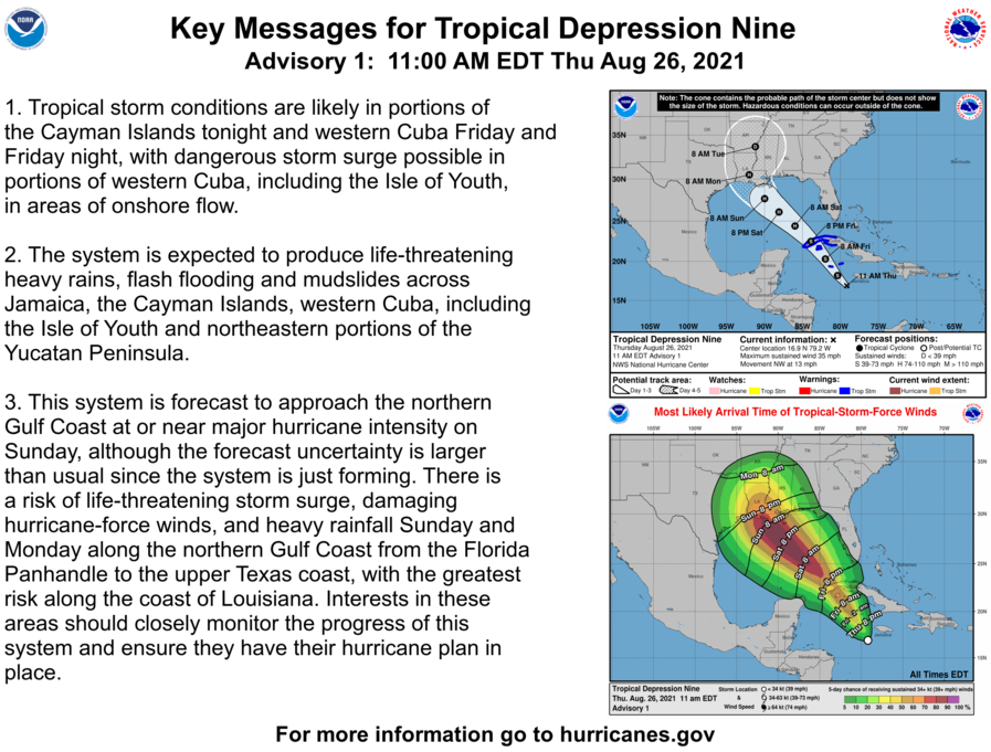
BULLETIN
Tropical Depression Nine Intermediate Advisory Number 1A
NWS National Hurricane Center Miami FL       AL092021
200 PM EDT Thu Aug 26 2021

...TROPICAL DEPRESSION EXPECTED TO STRENGTHEN OVER THE NORTHWESTERN
CARIBBEAN SEA...
...AIR FORCE RESERVE RECONNAISSANCE AIRCRAFT EN ROUTE...


SUMMARY OF 200 PM EDT...1800 UTC...INFORMATION
----------------------------------------------
LOCATION...17.5N 79.5W
ABOUT 95 MI...155 KM SW OF NEGRIL JAMAICA
ABOUT 165 MI...270 KM SE OF GRAND CAYMAN
MAXIMUM SUSTAINED WINDS...35 MPH...55 KM/H
PRESENT MOVEMENT...NW OR 325 DEGREES AT 13 MPH...20 KM/H
MINIMUM CENTRAL PRESSURE...1005 MB...29.68 INCHES


WATCHES AND WARNINGS
--------------------
CHANGES WITH THIS ADVISORY:

None.

SUMMARY OF WATCHES AND WARNINGS IN EFFECT:

A Tropical Storm Warning is in effect for...
* Cayman Islands
* Cuban provinces of Matanzas, Mayabeque, Havana, Artemisa, Pinar
del Rio, and the Isle of Youth

A Tropical Storm Warning means that tropical storm conditions are
expected somewhere within the warning area within 36 hours.

Interests elsewhere in central and western Cuba, in the northern
Yucatan Peninsula, and along the northern U.S. Gulf coast should
monitor the progress of this system.

For storm information specific to your area, please monitor
products issued by your national meteorological service.


DISCUSSION AND OUTLOOK
----------------------
At 200 PM EDT (1800 UTC), the center of Tropical Depression Nine was
located near latitude 17.5 North, longitude 79.5 West. The
depression is moving toward the northwest near 13 mph (20 km/h), and
this general motion should continue over the next few days.  On the
forecast track, the center of the depression will pass near or over
the Cayman Islands tonight, the Isle of Youth and western Cuba
Friday, and over the southeastern and central Gulf of Mexico Friday
night and Saturday.  The system is forecast to approach the U.S.
northern Gulf coast on Sunday.

Maximum sustained winds are near 35 mph (55 km/h) with higher
gusts. Steady strengthening is forecast during the next few days.
The depression is expected to become a tropical storm tonight, and
become a hurricane when it is near western Cuba or over the
southeastern Gulf of Mexico.  Additional strengthening is likely
over the Gulf of Mexico, and the system could be near major
hurricane strength when it approaches the northern Gulf coast.

The estimated minimum central pressure is 1005 mb (29.68 inches).


HAZARDS AFFECTING LAND
----------------------
Key messages for Tropical Depression Nine can be found in the
Tropical Cyclone Discussion under AWIPS header MIATCDAT4, WMO
header WTNT44 KNHC, and on the web at
hurricanes.gov/graphics_at4.shtml?key_messages.

STORM SURGE:  A dangerous storm surge will raise water levels by
as much as 2 to 4 feet above normal tide levels in areas of onshore
winds along the immediate coast of the Isle of Youth and near and to
the east of where the center crosses the coast of western Cuba.
Near the coast, the surge will be accompanied by large and
destructive waves.

WIND:  Tropical storm conditions are expected in the Cayman
Islands tonight, and are expected to reach the Isle of Youth and
portions of western Cuba in the warning area on Friday.

RAINFALL:  The depression is expected to produce total rainfall
accumulations of 6 to 10 inches with maximum totals of 15 inches
across Jamaica.  Rainfall totals of 8 to 12 inches with isolated
maximum amounts of 20 inches are expected across the Cayman
Islands, western Cuba, including the Isle of Youth, and the
northeast portions of the Yucatan Peninsula.  These rainfall amounts
may produce life-threatening flash floods and mudslides.

Rainfall from this system is likely to begin impacting portions
of the central U.S. Gulf Coast by early Sunday.

SURF:  Swells generated by this system will begin affecting Jamaica,
the Cayman Islands and Cuba tonight and Friday. These swells are
likely to cause life-threatening surf and rip current conditions.
Please consult products from your local weather office.
Tropical Depression 9 Forms
TROPICAL DEPRESSION NINE FORECAST/ADVISORY NUMBER   1
NWS NATIONAL HURRICANE CENTER MIAMI FL       AL092021
1500 UTC THU AUG 26 2021

CHANGES IN WATCHES AND WARNINGS WITH THIS ADVISORY...

THE GOVERNMENT OF THE CAYMAN ISLANDS HAS ISSUED A TROPICAL STORM
WARNING FOR THE CAYMAN ISLANDS...INCLUDING GRAND CAYMAN...LITTLE
CAYMAN...AND CAYMAN BRAC.

THE GOVERNMENT OF CUBA HAS ISSUED A TROPICAL STORM WARNING FOR THE
CUBAN PROVINCES OF MATANZAS...MAYABEQUE...HAVANA...ARTEMISA...PINAR
DEL RIO...AND THE ISLE OF YOUTH.

SUMMARY OF WATCHES AND WARNINGS IN EFFECT...

A TROPICAL STORM WARNING IS IN EFFECT FOR...
* CAYMAN ISLANDS
* CUBAN PROVINCES OF MATANZAS...MAYABEQUE...HAVANA...ARTEMISA...
PINAR DEL RIO...AND THE ISLE OF YOUTH

A TROPICAL STORM WARNING MEANS THAT TROPICAL STORM CONDITIONS ARE
EXPECTED SOMEWHERE WITHIN THE WARNING AREA WITHIN 36 HOURS.

INTERESTS ELSEWHERE IN CENTRAL AND WESTERN CUBA...IN THE NORTHERN
YUCATAN PENINSULA...AND ALONG THE NORTHERN U.S. GULF COAST SHOULD
MONITOR THE PROGRESS OF THIS SYSTEM.

TROPICAL DEPRESSION CENTER LOCATED NEAR 16.9N  79.2W AT 26/1500Z
POSITION ACCURATE WITHIN  40 NM

PRESENT MOVEMENT TOWARD THE NORTHWEST OR 325 DEGREES AT  11 KT

ESTIMATED MINIMUM CENTRAL PRESSURE 1005 MB
MAX SUSTAINED WINDS  30 KT WITH GUSTS TO  40 KT.
WINDS AND SEAS VARY GREATLY IN EACH QUADRANT.  RADII IN NAUTICAL
MILES ARE THE LARGEST RADII EXPECTED ANYWHERE IN THAT QUADRANT.

REPEAT...CENTER LOCATED NEAR 16.9N  79.2W AT 26/1500Z
AT 26/1200Z CENTER WAS LOCATED NEAR 16.4N  79.0W

FORECAST VALID 27/0000Z 18.2N  80.4W
MAX WIND  35 KT...GUSTS  45 KT.
34 KT... 60NE  40SE   0SW  60NW.

FORECAST VALID 27/1200Z 20.3N  82.0W
MAX WIND  45 KT...GUSTS  55 KT.
34 KT... 80NE  50SE  20SW  60NW.

FORECAST VALID 28/0000Z 22.5N  83.9W...OVER WESTERN CUBA
MAX WIND  55 KT...GUSTS  65 KT.
50 KT... 30NE   0SE   0SW   0NW.
34 KT... 90NE  60SE  40SW  70NW.

FORECAST VALID 28/1200Z 24.4N  86.0W...OVER SOUTHEASTERN GULF
MAX WIND  65 KT...GUSTS  80 KT.
64 KT... 20NE  20SE   0SW  20NW.
50 KT... 40NE  40SE  30SW  40NW.
34 KT...110NE  80SE  60SW  90NW.

FORECAST VALID 29/0000Z 26.1N  88.1W
MAX WIND  80 KT...GUSTS 100 KT.
50 KT... 50NE  50SE  30SW  50NW.
34 KT...130NE 110SE  60SW 110NW.

FORECAST VALID 29/1200Z 27.7N  90.0W
MAX WIND  95 KT...GUSTS 115 KT.
50 KT... 50NE  50SE  30SW  50NW.
34 KT...140NE 130SE  70SW 120NW.

EXTENDED OUTLOOK. NOTE...ERRORS FOR TRACK HAVE AVERAGED NEAR 150 NM
ON DAY 4 AND 175 NM ON DAY 5...AND FOR INTENSITY NEAR 15 KT EACH DAY

OUTLOOK VALID 30/1200Z 30.5N  92.0W...INLAND
MAX WIND  70 KT...GUSTS  85 KT.

OUTLOOK VALID 31/1200Z 33.7N  91.2W...INLAND
MAX WIND  30 KT...GUSTS  40 KT.

REQUEST FOR 3 HOURLY SHIP REPORTS WITHIN 300 MILES OF 16.9N  79.2W

INTERMEDIATE PUBLIC ADVISORY...WTNT34 KNHC/MIATCPAT4...AT 26/1800Z
8/26 Tropical Weather Outlook
Tropical Weather Outlook...Corrected
NWS National Hurricane Center Miami FL
800 AM EDT Thu Aug 26 2021

Corrected 5-day formation probability for the second system

For the North Atlantic...Caribbean Sea and the Gulf of Mexico:

Showers and thunderstorms continue to show signs of organization in
association with a broad area of low pressure located over the
west-central Caribbean Sea about 150 miles south-southwest of
Jamaica.  Environmental conditions remain conducive for additional
development, and a tropical depression or tropical storm is
expected to form later today or tonight while the system moves
northwestward over the northwestern Caribbean Sea, reaching the
Cayman Islands tonight and western Cuba and the Yucatan Channel
Friday and Friday night.  Given the recent developmental trends,
Tropical Storm Warnings for the Cayman Islands and western Cuba
could be required later this morning, and an Air Force Reserve
reconnaissance aircraft is scheduled to investigate the system
this afternoon.  Regardless of development, locally heavy rainfall
and flooding are possible over portions of Jamaica and the Cayman
Islands today and tonight, and will likely spread across Cuba
and the Yucatan Peninsula on Friday.

The system is expected to enter into the Gulf of Mexico Friday night
and continue moving northwestward toward the central or northwestern
U.S. Gulf coast, potentially bringing dangerous impacts from storm
surge, wind, and heavy rainfall to portions of the coasts of Texas,
Louisiana, Mississippi, Alabama, and the Florida Panhandle by Sunday
and Monday.  However, uncertainty in the system's exact track and
intensity remains large since the low is just beginning to form.
Interests in these areas should closely monitor the progress of this
system and ensure they have their hurricane plans in place.
Additional information on this system, including gale warnings, can
be found in High Seas Forecasts issued by the National Weather
Service.
* Formation chance through 48 hours...high...90 percent.
* Formation chance through 5 days...high...90 percent.

A trough of low pressure located over the central Atlantic about
600 miles east of Bermuda continues to produce disorganized showers
and thunderstorms.  Environmental conditions are forecast to be
generally conducive for development, and a tropical depression
is likely to form late this week or this weekend while the system
moves slowly eastward at 5 to 10 mph.
* Formation chance through 48 hours...medium...40 percent.
* Formation chance through 5 days...high...70 percent.

A tropical wave located over the central tropical Atlantic about
1000 miles west-southwest of the Cabo Verde Islands is producing
disorganized showers and thunderstorms.  Environmental conditions
appear a little more conducive for development during the next few
days, and a tropical depression could form by the weekend while the
system moves toward the west-northwest or northwest at 10 to 15
mph.  Upper-level winds could become less conducive for development
by early next week.
* Formation chance through 48 hours...medium...40 percent.
* Formation chance through 5 days...medium...50 percent.
4 on All SECPreseason List
Four Florida Gators were named to the preseason Coaches All-SEC Team on Tuesday. Defensive end Zachary Carter and cornerback Kaiir Elam were selected to the First Team, linebacker Ventrell Millermade the Second Team and receiver Jacob Copeland landed on the Third Team.
Elam’s selection comes as no surprise and just a day after he was named a preseason AP All-American. It’s the latest preseason honor for Carter as well after being named on the media’s preseason All-SEC First Team and the Wuerffel Trophy watchlist. Miller, last year’s team leader in tackles (88), and Copeland earned the same spots on the media’s preseason team.