BULLETIN
Tropical Storm Victor Advisory Number   2
NWS National Hurricane Center Miami FL       AL202021
800 PM CVT Wed Sep 29 2021

...VICTOR FORMS OVER THE EASTERN TROPICAL ATLANTIC...


SUMMARY OF 800 PM CVT...2100 UTC...INFORMATION
----------------------------------------------
LOCATION...8.3N 25.5W
ABOUT 540 MI...870 KM S OF THE CABO VERDE ISLANDS
MAXIMUM SUSTAINED WINDS...40 MPH...65 KM/H
PRESENT MOVEMENT...WNW OR 290 DEGREES AT 13 MPH...20 KM/H
MINIMUM CENTRAL PRESSURE...1005 MB...29.68 INCHES


WATCHES AND WARNINGS
--------------------
There are no coastal watches or warnings in effect.


DISCUSSION AND OUTLOOK
----------------------
At 800 PM CVT (2100 UTC), the center of Tropical Storm Victor was
located near latitude 8.3 North, longitude 25.5 West. Victor is
moving toward the west-northwest near 13 mph (20 km/h) and this
motion is expected to continue during the next couple of days,
followed by a turn to the northwest.

Maximum sustained winds have increased to near 40 mph (65 km/h)
with higher gusts. Steady strengthening is forecast, and Victor is
expected to become a hurricane in a day or two.

Tropical-storm-force winds extend outward up to 60 miles (95 km)
north of the center.

The estimated minimum central pressure is 1005 mb (29.68 inches).


HAZARDS AFFECTING LAND
----------------------
None
Monthly Archives: September 2021
Sam Advisory # 29
SBULLETIN
Hurricane Sam Advisory Number 29
NWS National Hurricane Center Miami FL AL182021
500 PM AST Wed Sep 29 2021
...CATEGORY 4 HURRICANE SAM PASSING WELL TO THE EAST-NORTHEAST OF
THE NORTHERN LEEWARD ISLANDS...
SUMMARY OF 500 PM AST...2100 UTC...INFORMATION
----------------------------------------------
LOCATION...20.2N 57.6W
ABOUT 385 MI...620 KM ENE OF THE NORTHERN LEEWARD ISLANDS
MAXIMUM SUSTAINED WINDS...130 MPH...215 KM/H
PRESENT MOVEMENT...NW OR 310 DEGREES AT 9 MPH...15 KM/H
MINIMUM CENTRAL PRESSURE...945 MB...27.91 INCHES
WATCHES AND WARNINGS
--------------------
There are no coastal watches or warnings in effect.
DISCUSSION AND OUTLOOK
----------------------
At 500 PM AST (2100 UTC), the center of Hurricane Sam was located
near latitude 20.2 North, longitude 57.6 West. Sam is moving toward
the northwest near 9 mph (15 km/h), and this general motion with an
increase in forward speed is expected during the next couple of
days. A turn toward the north is forecast by Friday. On the
forecast track, Sam will continue to pass well to the
east-northeast of the northern Leeward Islands through tonight.
Maximum sustained winds are near 130 mph (215 km/h) with higher
gusts. Sam is a category 4 hurricane on the Saffir-Simpson
Hurricane Wind Scale. Some fluctuations in intensity are expected
during the next couple of days, but Sam is forecast to remain a
major hurricane through late this week.
Hurricane-force winds extend outward up to 40 miles (65 km) from the
center and tropical-storm-force winds extend outward up to 140 miles
(220 km).
An Air Force Reserve Unit Hurricane Hunter aircraft reported a
minimum central pressure of 945 mb (27.91 inches).
HAZARDS AFFECTING LAND
----------------------
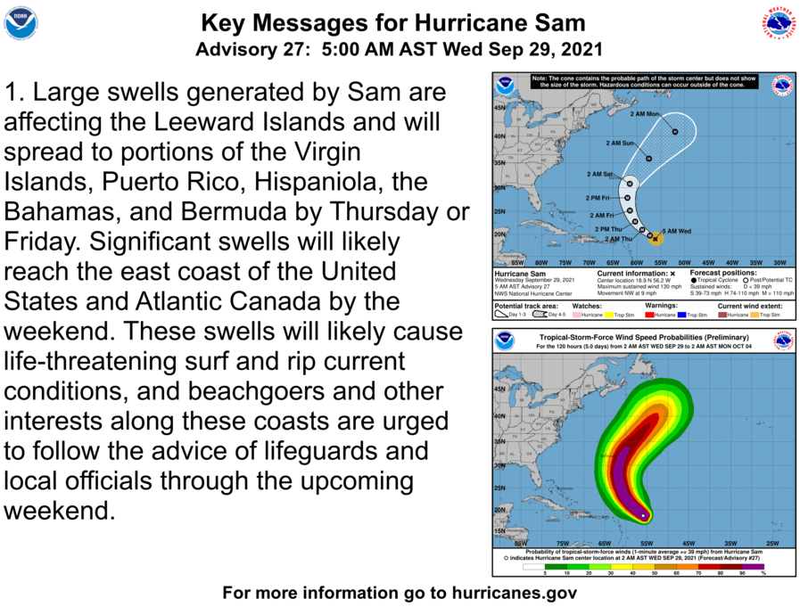
Key messages for Sam can be found in the Tropical Cyclone
Discussion under AWIPS header MIATCDAT3 and WMO header WTNT43 KNHC.
SURF: Swells generated by Sam will impact the Lesser Antilles
during the next several days. Swells are expected to reach Bermuda
and the Bahamas in a day or so, and then spread to the United
States east coast by this weekend. These swells could cause
life-threatening surf and rip current conditions. Please consult
products from your local weather office.
T.D. 20 Advisory # 1
BULLETIN
Tropical Depression Twenty Advisory Number   1
NWS National Hurricane Center Miami FL       AL202021
200 PM CVT Wed Sep 29 2021

...TROPICAL DEPRESSION FORMS OVER THE FAR EASTERN TROPICAL
ATLANTIC...


SUMMARY OF 200 PM CVT...1500 UTC...INFORMATION
----------------------------------------------
LOCATION...8.3N 24.6W
ABOUT 535 MI...860 KM S OF THE CABO VERDE ISLANDS
MAXIMUM SUSTAINED WINDS...35 MPH...55 KM/H
PRESENT MOVEMENT...WNW OR 290 DEGREES AT 14 MPH...22 KM/H
MINIMUM CENTRAL PRESSURE...1007 MB...29.74 INCHES


WATCHES AND WARNINGS
--------------------
There are no coastal watches or warnings in effect.


DISCUSSION AND OUTLOOK
----------------------
At 200 PM CVT (1500 UTC), the center of Tropical Depression Twenty
was located near latitude 8.3 North, longitude 24.6 West. The
depression is moving toward the west-northwest near 14 mph (22
km/h), and this motion is expected to continue during the next
couple of days, followed by a turn to the northwest.

Maximum sustained winds are near 35 mph (55 km/h) with higher gusts.
Steady strengthening is forecast, and the depression is expected to
become a tropical storm tonight and a hurricane in a couple of days.

The estimated minimum central pressure is 1007 mb (29.74 inches).


HAZARDS AFFECTING LAND
----------------------
None
Sam Advisory # 28
BULLETIN
Hurricane Sam Advisory Number  28
NWS National Hurricane Center Miami FL       AL182021
1100 AM AST Wed Sep 29 2021

...POWERFUL SAM CONTINUES MOVING SLOWLY NORTHWESTWARD...


SUMMARY OF 1100 AM AST...1500 UTC...INFORMATION
-----------------------------------------------
LOCATION...19.4N 57.0W
ABOUT 405 MI...655 KM ENE OF THE NORTHERN LEEWARD ISLANDS
MAXIMUM SUSTAINED WINDS...130 MPH...215 KM/H
PRESENT MOVEMENT...NW OR 310 DEGREES AT 9 MPH...15 KM/H
MINIMUM CENTRAL PRESSURE...949 MB...28.03 INCHES


WATCHES AND WARNINGS
--------------------
There are no coastal watches or warnings in effect.


DISCUSSION AND OUTLOOK
----------------------
At 1100 AM AST (1500 UTC), the center of Hurricane Sam was located
near latitude 19.4 North, longitude 57.0 West.  Sam is moving toward
the northwest near 9 mph (15 km/h), and this general motion with an
increase in forward speed is expected during the next couple of
days.  A turn toward the north is forecast by Friday.  On the
forecast track, Sam will pass well to the east-northeast of the
northern Leeward Islands through tonight.

Maximum sustained winds are near 130 mph (215 km/h) with higher
gusts.  Sam is a category 4 hurricane on the Saffir-Simpson
Hurricane Wind Scale.  Some fluctuations in intensity are expected
during the next couple of days, but Sam is forecast to remain a
major hurricane through late this week.

Hurricane-force winds extend outward up to 40 miles (65 km) from the
center and tropical-storm-force winds extend outward up to 125 miles
(205 km).

The minimum central pressure estimated from NOAA Hurricane Hunter
aircraft observations is 949 mb (28.03 inches).


HAZARDS AFFECTING LAND
----------------------
Key messages for Sam can be found in the Tropical Cyclone
Discussion under AWIPS header MIATCDAT3 and WMO header WTNT43 KNHC.

SURF:  Swells generated by Sam will impact the Lesser Antilles
during the next several days.  Swells are expected to reach Bermuda
and the Bahamas in a day or so, and then spread to the United
States east coast by this weekend.  These swells could cause
life-threatening surf and rip current conditions.  Please consult
products from your local weather office.

Sam Advisory # 27
BULLETIN
Hurricane Sam Advisory Number  27
NWS National Hurricane Center Miami FL       AL182021
500 AM AST Wed Sep 29 2021

...AIR FORCE HURRICANE HUNTERS FIND SAM FLUCTUATING IN STRENGTH...


SUMMARY OF 500 AM AST...0900 UTC...INFORMATION
----------------------------------------------
LOCATION...18.9N 56.2W
ABOUT 455 MI...730 KM E OF THE NORTHERN LEEWARD ISLANDS
MAXIMUM SUSTAINED WINDS...130 MPH...215 KM/H
PRESENT MOVEMENT...NW OR 310 DEGREES AT 9 MPH...15 KM/H
MINIMUM CENTRAL PRESSURE...950 MB...28.06 INCHES


WATCHES AND WARNINGS
--------------------
There are no coastal watches or warnings in effect.


DISCUSSION AND OUTLOOK
----------------------
At 500 AM AST (0900 UTC), the center of Hurricane Sam was located
near latitude 18.9 North, longitude 56.2 West. Sam is moving toward
the northwest near 9 mph (15 km/h), and this general motion with an
increase in forward speed is expected during the next couple of
days.  A turn toward the north is forecast by Friday.  On the
forecast track, Sam will pass well to the east and northeast of
the northern Leeward Islands through tonight.

Data from an Air Force Reserve Hurricane Hunter aircraft indicate
that the maximum sustained winds are near 130 mph (215 km/h) with
higher gusts.  Sam is a category 4 hurricane on the Saffir-Simpson
Hurricane Wind Scale.  Some fluctuations in intensity are expected
during the next couple of days, but Sam is forecast to remain a
major hurricane through late this week.

Hurricane-force winds extend outward up to 40 miles (65 km) from the
center and tropical-storm-force winds extend outward up to 125 miles
(205 km).

The latest minimum central pressure estimated from reconnaissance
aircraft data is 950 mb (28.06 inches).


HAZARDS AFFECTING LAND
----------------------
Key messages for Sam can be found in the Tropical Cyclone
Discussion under AWIPS header MIATCDAT3 and WMO header WTNT43 KNHC.

SURF:  Swells generated by Sam will impact the Lesser Antilles
during the next several days.  Swells are expected to reach Bermuda
and the Bahamas in a day or two, and then spread to the United
States east coast by this weekend.  These swells could cause
life-threatening surf and rip current conditions.  Please consult
products from your local weather office.
Besides Sam, we have…..
Tropical Weather Outlook
NWS National Hurricane Center Miami FL
800 AM EDT Tue Sep 28 2021

For the North Atlantic...Caribbean Sea and the Gulf of Mexico:

The National Hurricane Center is issuing advisories on Hurricane
Sam, located several hundred miles east of the northern Leeward
Islands.

1. A broad area of low pressure located several hundred miles southwest of the Cabo Verde Islands continues to produce an area of disorganized showers and thunderstorms. Environmental conditions are conducive for gradual development, and a tropical depression is likely to form during the next couple of days while the system moves westward to west-northwestward at 5 to 10 mph over the central tropical Atlantic.
* Formation chance through 48 hours...high...70 percent.
* Formation chance through 5 days...high...80 percent.

2. Showers and thunderstorms are showing signs of organization in
association with a tropical wave and broad area of low pressure
located over the far eastern tropical Atlantic.  Environmental
conditions are conducive for development, and a tropical depression is likely to form in a day or two while the disturbance moves west-northwestward at 10 to 15 mph over the eastern tropical
Atlantic.
* Formation chance through 48 hours...high...80 percent.
* Formation chance through 5 days...high...90 percent.

3. A well-defined low pressure area associated with the remnants
of Peter is located about 350 miles east-northeast of Bermuda. The
associated showers and thunderstorms have increased a little this
morning, but are still not well organized.  This system could become a short-lived tropical depression while moving northeastward at about 10 mph before upper-level winds increase on Wednesday.
* Formation chance through 48 hours...medium...50 percent.
* Formation chance through 5 days...medium...50 percent.
Sam Advisory # 24
BULLETIN
Hurricane Sam Advisory Number  24
NWS National Hurricane Center Miami FL       AL182021
1100 AM AST Tue Sep 28 2021

...SAM REMAINS A POWERFUL CATEGORY 4 HURRICANE OVER THE TROPICAL
ATLANTIC...


SUMMARY OF 1100 AM AST...1500 UTC...INFORMATION
-----------------------------------------------
LOCATION...17.5N 54.3W
ABOUT 580 MI...935 KM E OF THE NORTHERN LEEWARD ISLANDS
MAXIMUM SUSTAINED WINDS...130 MPH...215 KM/H
PRESENT MOVEMENT...NW OR 305 DEGREES AT 8 MPH...13 KM/H
MINIMUM CENTRAL PRESSURE...952 MB...28.12 INCHES


WATCHES AND WARNINGS
--------------------
There are no coastal watches or warnings in effect.


DISCUSSION AND OUTLOOK
----------------------
At 1100 AM AST (1500 UTC), the eye of Hurricane Sam was located near
latitude 17.5 North, longitude 54.3 West. Sam is moving toward the
northwest near 8 mph (13 km/h) and this motion with an increase in
forward is expected during the next couple of days.  A turn toward
the north is forecast to occur by Friday.  On the forecast track,
Sam will pass well to the east of the northern Leeward Islands
through Wednesday.

Maximum sustained winds remain near 130 mph (215 km/h) with higher
gusts.  Sam is a category 4 hurricane on the Saffir-Simpson
Hurricane Wind Scale.   Some fluctuations in intensity are expected
during the next couple of days, but Sam is forecast to remain a
major hurricane through late this week.

Hurricane-force winds extend outward up to 40 miles (65 km) from the
center and tropical-storm-force winds extend outward up to 140 miles
(220 km).

The estimated minimum central pressure is 952 mb (28.12 inches).


HAZARDS AFFECTING LAND
----------------------
Key messages for Sam can be found in the Tropical Cyclone
Discussion under AWIPS header MIATCDAT3 and WMO header WTNT43 KNHC.

SURF:  Swells generated by Sam will impact the Lesser Antilles
during the next several days.  Swells are expected to reach Bermuda
and the Bahamas in a couple of days, and then spread to the United
States east coast late this week.  These swells could cause
life-threatening surf and rip current conditions.  Please consult
products from your local weather office.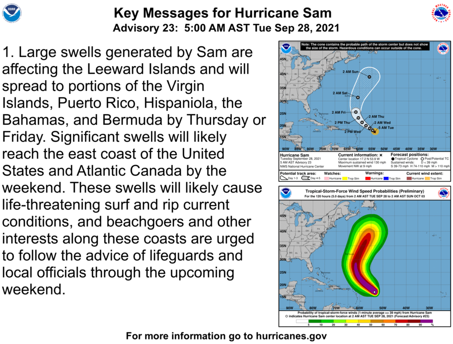
Sam Advisory # 21
BULLETIN
Hurricane Sam Advisory Number  21
NWS National Hurricane Center Miami FL       AL182021
500 PM AST Mon Sep 27 2021

...SAM BEGINNING TO REGROUP AFTER WEAKENING...
...SOME REINTENSIFICATION EXPECTED THROUGH TONIGHT...


SUMMARY OF 500 PM AST...2100 UTC...INFORMATION
----------------------------------------------
LOCATION...16.3N 52.7W
ABOUT 700 MI...1125 KM E OF THE NORTHERN LEEWARD ISLANDS
MAXIMUM SUSTAINED WINDS...120 MPH...195 KM/H
PRESENT MOVEMENT...NW OR 315 DEGREES AT 9 MPH...15 KM/H
MINIMUM CENTRAL PRESSURE...957 MB...28.26 INCHES


WATCHES AND WARNINGS
--------------------
There are no coastal watches or warnings in effect.


DISCUSSION AND OUTLOOK
----------------------
At 500 PM AST (2100 UTC), the center of Hurricane Sam was located
near latitude 16.3 North, longitude 52.7 West. Sam is moving toward
the northwest near 9 mph (15 km/h), and this motion is expected to
continue for the next few days, with an increase in forward speed
beginning on Thursday.  A turn to the north is expected by Friday.
On the forecast track, Sam will pass well to the northeast of the
northern Leeward Islands Wednesday and Thursday.

An Air Force Reserve Hurricane Hunter aircraft indicates that the
maximum sustained winds are near 120 mph (195 km/h) with higher
gusts.  Sam is a category 3 hurricane on the Saffir-Simpson
Hurricane Wind Scale.  Some strengthening is expected through
tonight. Thereafter, fluctuations in intensity are possible through
Thursday.

Hurricane-force winds extend outward up to 30 miles (45 km) from the
center and tropical-storm-force winds extend outward up to 105 miles
(165 km).

The minimum central pressure measured by the aircraft is 957 mb
(28.26 inches).


HAZARDS AFFECTING LAND
----------------------
Key messages for Sam can be found in the Tropical Cyclone
Discussion under AWIPS header MIATCDAT3 and WMO header WTNT43 KNHC.

SURF:  Swells generated by Sam will impact the Lesser Antilles for
the next several days.  Swells are expected to reach Bermuda and the
Bahamas mid-to-late week, and then spread to the United States east
coast late this week.  These swells could cause life-threatening
surf and rip current conditions. Please consult products from your
local weather office.
Sam Advisory # 20
BULLETIN
Hurricane Sam Advisory Number  20
NWS National Hurricane Center Miami FL       AL182021
1100 AM AST Mon Sep 27 2021

...HURRICANE HUNTER AIRCRAFT CURRENTLY INVESTIGATING SAM...


SUMMARY OF 1100 AM AST...1500 UTC...INFORMATION
-----------------------------------------------
LOCATION...15.7N 52.1W
ABOUT 745 MI...1200 KM ESE OF THE NORTHERN LEEWARD ISLANDS
MAXIMUM SUSTAINED WINDS...125 MPH...205 KM/H
PRESENT MOVEMENT...NW OR 310 DEGREES AT 8 MPH...13 KM/H
MINIMUM CENTRAL PRESSURE...966 MB...28.53 INCHES


WATCHES AND WARNINGS
--------------------
There are no coastal watches or warnings in effect.


DISCUSSION AND OUTLOOK
----------------------
At 1100 AM AST (1500 UTC), the center of Hurricane Sam was located
near latitude 15.6 North, longitude 52.0 West.  Sam is moving toward
the northwest near 8 mph (13 km/h) and this motion is expected to
continue for the next few days, with an increase in forward speed
beginning on Thursday.  A turn to the north is expected on Friday.
On the forecast track, Sam will pass well to the northeast of the
northern Leeward Islands Wednesday and Thursday.

Maximum sustained winds are near 125 mph (205 km/h) with higher
gusts.  Sam is a category 3 hurricane on the Saffir-Simpson
Hurricane Wind Scale.  Fluctuations in intensity are possible
during the next days, although Sam is forecast to remain a major
hurricane through at least Thursday night.

Hurricane-force winds extend outward up to 30 miles (45 km) from the
center and tropical-storm-force winds extend outward up to 105 miles
(165 km).

The minimum central pressure estimated from NOAA Hurricane Hunter
aircraft observations is 966 mb (28.53 inches).


HAZARDS AFFECTING LAND
----------------------
SURF:  Swells generated by Sam will reach the Lesser Antilles today
and impact these islands for the next several days.  Swells are
expected to reach Bermuda and the Bahamas mid-to-late week, and
then spread to the United States east coast late this week.  These
swells could cause life-threatening surf and rip current conditions.
Please consult products from your local weather office.


NEXT ADVISORY
-------------
Next complete advisory at 500 PM AST.
BOLO – signal Zero