Tropical Weather Outlook
NWS National Hurricane Center Miami FL
200 PM EDT Tue May 31 2022

For the North Atlantic...Caribbean Sea and the Gulf of Mexico:

Near the Yucatan Peninsula and Southeastern Gulf of Mexico:
A large and complex area of low pressure is expected to develop near the Yucatan Peninsula and the northwestern Caribbean Sea in a couple of days, partially related to the remnants of Agatha from the eastern Pacific.  Despite strong upper-level winds over the area, this system is likely to become a tropical depression while it moves northeastward over the northwestern Caribbean Sea and
southeastern Gulf of Mexico late Thursday or Friday.

Regardless of development, locally heavy rainfall is likely across portions of southeastern Mexico, the Yucatan Peninsula, Guatemala, and Belize during the next couple of days, spreading across western Cuba, southern Florida, and the Florida Keys on Friday and Saturday.

Interests in the Yucatan Peninsula, western Cuba, the Florida Keys
and the Florida Peninsula should monitor the progress of this
system.
* Formation chance through 48 hours...low...30 percent.
* Formation chance through 5 days...high...70 percent.

$$
Tropical Update – 3/30
Tropical Weather Outlook
NWS National Hurricane Center Miami FL
200 PM EDT Mon May 30 2022

For the North Atlantic...Caribbean Sea and the Gulf of Mexico:

Near the Yucatan Peninsula:
A large and complex area of low pressure is expected to develop
near the Yucatan Peninsula and the northwestern Caribbean Sea in
a few days, partially related to the remnants of Hurricane Agatha
from the eastern Pacific. This system is forecast to move slowly
eastward or northeastward and gradual development is possible
by the latter part of this week.  Regardless of development,
locally heavy rainfall is likely across portions of southern
Mexico, the Yucatan Peninsula, Guatemala, and Belize through
the week.
* Formation chance through 48 hours...low...near 0 percent.
* Formation chance through 5 days...medium...40 percent.
God Bless all who served and protected.
 Thanks
Gainesville Regional Schedule
GAINESVILLE, Fla. – The University of Florida was handed the No. 13 national seed for the 2022 NCAA Baseball Tournament, as announced by the NCAA Selection Committee on ESPN2 on Monday.
Joining host-program Florida at the Gainesville Regional is No. 2-seed Oklahoma, No. 3-seed Liberty and No. 4-seed Central Michigan. The Gators will take on Central Michigan this upcoming Friday night, June 3, in the second game of the day at 6:30 p.m. ET on ESPN+.
With the NCAA announcing the complete, 64-team bracket and pairings on Monday, Florida earned a spot in an NCAA Regional for the 37th time in program history. Overall, the 2022 campaign represents the 18th time that Florida has hosted an NCAA Regional, including the second-consecutive bid after hosting in the inaugural season of Condron Family Ballpark last year.
From June 3-6, 64 teams will compete across 16 NCAA Regional sites to determine which 16 programs will advance to NCAA Super Regionals, scheduled for June 10-13.
Complete Schedule for the 2022 NCAA Gainesville Regional
Friday, June 3
Game One: 1 p.m. ET – Liberty vs. Oklahoma (ESPN+)
Game Two: 6:30 p.m. ET – Central Michigan vs. Florida (ESPN+)
Saturday, June 4
Game Three: TBA – Loser Game One vs. Loser Game Two
Game Four: TBA – Winner Game One vs. Winner Game Two
Sunday, June 5
Game Five: TBA – Loser Game Four vs. Winner Game Three
Game Six: TBA – Winner Game Four vs. Winner Game Five
Monday, June 6
Game Seven (if necessary): TBA – Winner Game Six vs. Loser Game Six
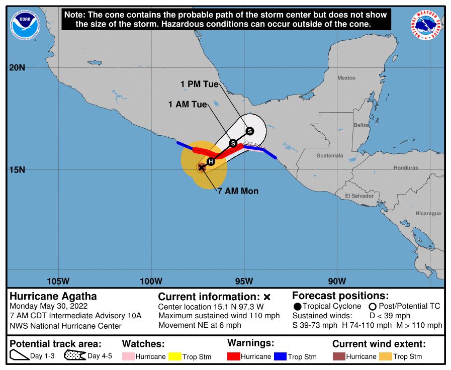
Agatha Update 5/30 7am
BULLETIN
Hurricane Agatha Intermediate Advisory Number 10A
NWS National Hurricane Center Miami FL       EP012022
700 AM CDT Mon May 30 2022

...AGATHA EXPECTED TO MAKE LANDFALL IN SOUTHERN MEXICO LATER
TODAY...
...STRONG WINDS AND HEAVY RAIN WILL CONTINUE TO INCREASE THROUGH THE
DAY...


SUMMARY OF 700 AM CDT...1200 UTC...INFORMATION
----------------------------------------------
LOCATION...15.1N 97.3W
ABOUT 65 MI...110 KM SW OF PUERTO ANGEL MEXICO
MAXIMUM SUSTAINED WINDS...110 MPH...175 KM/H
PRESENT MOVEMENT...NE OR 55 DEGREES AT 6 MPH...9 KM/H
MINIMUM CENTRAL PRESSURE...964 MB...28.47 INCHES


WATCHES AND WARNINGS
--------------------
CHANGES WITH THIS ADVISORY:

None

SUMMARY OF WATCHES AND WARNINGS IN EFFECT:

A Hurricane Warning is in effect for...
* Salina Cruz to Lagunas de Chacahua

A Hurricane Watch is in effect for...
* Salina Cruz eastward to Barra De Tonala

A Tropical Storm Warning is in effect for...
* Salina Cruz eastward to Boca de Pijijiapan
* Lagunas de Chacahua westward to Punta Maldonado

A Hurricane Warning means that hurricane conditions are expected
somewhere within the warning area.

A Hurricane Watch means that hurricane conditions are possible
within the watch area.

A Tropical Storm Warning means that tropical storm conditions are
expected somewhere within the warning area.

Interests elsewhere in southern Mexico should closely monitor the
progress of Agatha.

For storm information specific to your area, please monitor
products issued by your national meteorological service.


DISCUSSION AND OUTLOOK
----------------------
At 700 AM CDT (1200 UTC), the center of Hurricane Agatha was located
near latitude 15.1 North, longitude 97.3 West.  Agatha is moving
toward the northeast near 6 mph (9 km/h), and this general motion is
expected to continue through Tuesday.  On the forecast track, the
center of Agatha will make landfall in the state of Oaxaca, Mexico,
this afternoon or this evening.

Maximum sustained winds remain near 110 mph (175 km/h) with higher
gusts.  Little change in strength is expected today before Agatha
reaches the coast of Oaxaca.  Rapid weakening is expected after
landfall, and Agatha is forecast to dissipate over southeastern
Mexico by late Tuesday.

Hurricane-force winds extend outward up to 15 miles (30 km) from
the center and tropical-storm-force winds extend outward up to 90
miles (150 km).

The estimated minimum central pressure is 964 mb (28.47 inches).


HAZARDS AFFECTING LAND
----------------------
WIND:  Hurricane conditions are expected in the hurricane warning
area and possible in the watch area by this afternoon.  Tropical
storm conditions have begun along the coast of Oaxaca and will
spread eastward within the warning area through the day.

STORM SURGE:  Storm surge is expected to produce extremely dangerous
coastal flooding in areas of onshore winds near and to the east of
where the center of Agatha makes landfall.  Near the coast, the
surge will be accompanied by large and destructive waves.

RAINFALL: Agatha will produce heavy rains over portions of southern
Mexico through Tuesday night. The following rainfall amounts are
currently expected:

Mexican state of Oaxaca: 10 to 16 inches, with isolated maximum
amounts of 20 inches possible. Life-threatening flash flooding and
mudslides may occur.

Mexican state of Chiapas: 5 to 10 inches, with isolated maximum
amounts of 15 inches possible. Life-threatening flash flooding and
mudslides may occur.

Mexican states of Veracruz, Tabasco and eastern portions of
Guerrero: 2 to 4 inches, with isolated maximum amounts of 6 inches
possible.

SURF:  Large swells generated by Agatha will affect the coast of
southern Mexico during the next day or two.  These swells are
likely to cause life-threatening surf and rip current conditions.
Please consult products from your local weather office.
Tropical Update, 5/29 8pm
Tropical Weather Outlook
NWS National Hurricane Center Miami FL
800 PM EDT Sun May 29 2022

For the North Atlantic...Caribbean Sea and the Gulf of Mexico:

Near the Yucatan Peninsula:
A large and complex area of low pressure is expected to develop
across Central America, the Yucatan Peninsula, and the southwest
Gulf of Mexico in a few days, partially related to the remnants of
Hurricane Agatha from the eastern Pacific. Some gradual development
is possible within this system in the far southwest Gulf of Mexico
by mid-week or in the northwest Caribbean by the latter part of this
week as the larger low complex drifts eastward or northeastward.
Regardless of development, locally heavy rains will be possible
across southern Mexico, the Yucatan Peninsula, Guatemala, and Belize
through the week.
* Formation chance through 48 hours...low...near 0 percent.
* Formation chance through 5 days...low...30 percent.
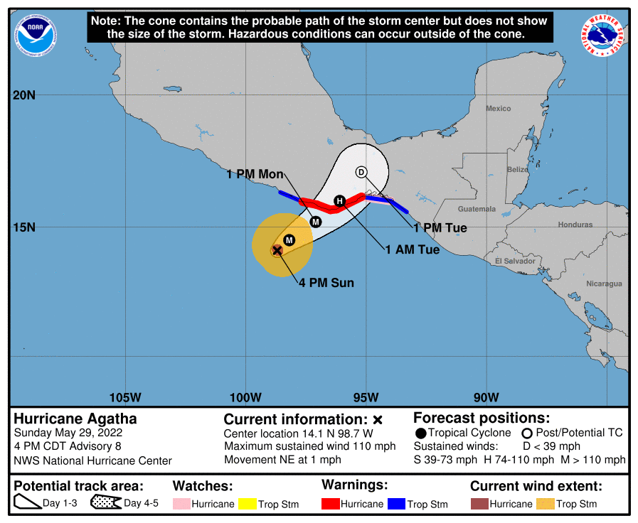
Agatha Advisory # 8
BULLETIN
Hurricane Agatha Advisory Number   8
NWS National Hurricane Center Miami FL       EP012022
400 PM CDT Sun May 29 2022

...AGATHA ALMOST A MAJOR HURRICANE...
...WEATHER CONDITIONS EXPECTED TO BEGIN DETERIORATING IN SOUTHERN
MEXICO TONIGHT...


SUMMARY OF 400 PM CDT...2100 UTC...INFORMATION
----------------------------------------------
LOCATION...14.1N 98.7W
ABOUT 185 MI...295 KM SW OF PUERTO ANGEL MEXICO
MAXIMUM SUSTAINED WINDS...110 MPH...175 KM/H
PRESENT MOVEMENT...NE OR 45 DEGREES AT 1 MPH...2 KM/H
MINIMUM CENTRAL PRESSURE...964 MB...28.47 INCHES


WATCHES AND WARNINGS
--------------------
CHANGES WITH THIS ADVISORY:

None

SUMMARY OF WATCHES AND WARNINGS IN EFFECT:

A Hurricane Warning is in effect for...
* Salina Cruz to Lagunas de Chacahua

A Hurricane Watch is in effect for...
* Salina Cruz eastward to Barra De Tonala

A Tropical Storm Warning is in effect for...
* Salina Cruz eastward to Boca de Pijijiapan
* Lagunas de Chacahua westward to Punta Maldonado

A Hurricane Warning means that hurricane conditions are expected
somewhere within the warning area within 36 hours. Preparations to
protect life and property should be rushed to completion.

A Hurricane Watch means that hurricane conditions are possible
within the watch area.

A Tropical Storm Warning means that tropical storm conditions are
expected somewhere within the warning area.

Interests elsewhere in southern Mexico should closely monitor the
progress of Agatha.

For storm information specific to your area, please monitor
products issued by your national meteorological service.


DISCUSSION AND OUTLOOK
----------------------
At 400 PM CDT (2100 UTC), the center of Hurricane Agatha was located near latitude 14.1 North, longitude 98.7 West. Agatha is drifting to the northeast near 1 mph (2 km/h), and a faster northeastward motion is expected to begin tonight.  On the forecast track,the center of Agatha will make landfall in southern Mexico Monday afternoon or evening.

Maximum sustained winds have increased to near 110 mph (175 km/h)
with higher gusts.  Additional strengthening is expected during the next 12 to 24 hours and Agatha is forecast to become a major
hurricane when it reaches the coast of southern Mexico on Monday.

Hurricane-force winds extend outward up to 15 miles (30 km) from the center and tropical-storm-force winds extend outward up to 115 miles (185 km).

The minimum central pressure based on data from the Air Force
Hurricane Hunter aircraft is 964 mb (28.47 inches).


HAZARDS AFFECTING LAND
----------------------
WIND:  Hurricane conditions are expected in the hurricane warning
area and possible in the watch area on Monday, with tropical storm
conditions beginning tonight or early Monday.

STORM SURGE:  Storm surge is expected to produce extremely dangerous coastal flooding in areas of onshore winds near and to the east of where the center of Agatha makes landfall.  Near the coast, the surge will be accompanied by large and destructive waves.

RAINFALL: Agatha will produce heavy rains over portions of southern Mexico through Tuesday night. The following rainfall amounts are currently expected:

Mexican state of Oaxaca: 10 to 16 inches, with isolated maximum
amounts of 20 inches possible. Life-threatening flash flooding and
mudslides may occur.

Mexican state of Chiapas: 5 to 10 inches, with isolated maximum
amounts of 15 inches possible. Life-threatening flash flooding and
mudslides may occur.

Eastern portions of the Mexican state of Guerrero: 2 to 6 inches,
with isolated maximum amounts of 10 inches possible.
Life-threatening flash flooding and mudslides may occur.

Mexican states of VeraCruz and Tabasco: 2 to 4 inches, with isolated maximum amounts of 6 inches possible.

SURF:  Large swells generated by Agatha will affect the coast of
southern Mexico during the next couple of days.  These swells are
likely to cause life-threatening surf and rip current conditions.
Please consult products from your local weather office.
Agatha Key Message

Championship Game Day

Agatha Advisory #3
Tropical Storm Agatha Advisory Number   3
NWS National Hurricane Center Miami FL       EP012022
1000 AM CDT Sat May 28 2022

...AGATHA MOVING SLOWLY OFF SOUTHERN MEXICO...
...EXPECTED TO STRENGTHEN TO A HURRICANE AS IT APPROACHES THE
COAST...


SUMMARY OF 1000 AM CDT...1500 UTC...INFORMATION
-----------------------------------------------
LOCATION...13.2N 98.4W
ABOUT 215 MI...345 KM SW OF PUERTO ANGEL MEXICO
MAXIMUM SUSTAINED WINDS...45 MPH...75 KM/H
PRESENT MOVEMENT...WNW OR 285 DEGREES AT 5 MPH...7 KM/H
MINIMUM CENTRAL PRESSURE...1002 MB...29.59 INCHES


WATCHES AND WARNINGS
--------------------
CHANGES WITH THIS ADVISORY:

None.

SUMMARY OF WATCHES AND WARNINGS IN EFFECT:

A Hurricane Watch is in effect for...
* The southern coast of Mexico from Salina Cruz to Punta Maldonado

A Hurricane Watch means that hurricane conditions are possible
within the watch area.  A watch is typically issued 48 hours
before the anticipated first occurrence of tropical-storm-force
winds, conditions that make outside preparations difficult or
dangerous.

Interests elsewhere in southern Mexico should closely monitor the
progress of Agatha.  Additional watches and warnings will likely be
required for portions of this area later today.

For storm information specific to your area, please monitor
products issued by your national meteorological service.


DISCUSSION AND OUTLOOK
----------------------
At 1000 AM CDT (1500 UTC), the center of Tropical Storm Agatha was
located near latitude 13.2 North, longitude 98.4 West. Agatha is
moving toward the west-northwest near 5 mph (7 km/h). A turn toward
the northwest is expected later today, followed by a turn toward the
northeast by Sunday.  On the forecast track, the center of Agatha
will approach the southern coast of Mexico on Sunday and make
landfall there on Monday.

Maximum sustained winds are near 45 mph (75 km/h) with higher gusts.
Additional steady to rapid strengthening is forecast, and Agatha is
expected to become a hurricane on Sunday.

Tropical-storm-force winds extend outward up to 45 miles (75 km)
from the center.

The estimated minimum central pressure is 1002 mb (29.59 inches).


HAZARDS AFFECTING LAND
----------------------
WIND:  Hurricane conditions are possible within the hurricane watch
area on Monday, with tropical storm conditions possible late
Sunday or early Monday.

STORM SURGE:  Storm surge could produce coastal flooding near and to
the east of where the center passes the coast in areas of onshore
winds. The surge may be accompanied by large and destructive waves.

RAINFALL:  Agatha will produce heavy rains over portions of
southern Mexico by Sunday into Tuesday night. The following rainfall
amounts are currently expected:

Mexican state of Oaxaca: 10 to 16 inches, with isolated maximum
amounts of 20 inches possible. Life-threatening flash flooding and
mudslides may occur.

Mexican states of Chiapas and the eastern portions of Guerrero: 5 to
10 inches, with isolated maximum amounts of 15 inches possible.
Life-threatening flash flooding and mudslides may occur.

Mexican states of Vera Cruz and Tabasco: 2 to 4 inches, with
isolated maximum amounts of 6 inches possible.


NEXT ADVISORY
-------------
Next intermediate advisory at 100 PM CDT.
Next complete advisory at 400 PM CDT.